
Königsleitenspitze
| Königsleitenspitze | ||
|---|---|---|
 |
||
| height | 2315 m above sea level A. | |
| location | Salzburg / Tyrol border , Austria | |
| Mountains | Kitzbühel Alps | |
| Notch height | 71 m | |
| Coordinates | 47 ° 15 '42 " N , 12 ° 5' 23" E | |
|
||

The Königsleitenspitze is 2315 m above sea level. A. high mountain in the Kitzbühel Alps on the border of the Austrian states of Salzburg and Tyrol , which is heavily developed for tourism. It is the local mountain of Königsleiten .
Location and surroundings
The mountain lies north of the Gerlos Pass and west of the Salzach Valley . The closest places are Königsleiten and Gerlos . Neighboring peaks are the Falschriedel and the Ochsenkopf in the northwest and the Müllach vulture in the northeast .
Tourist development
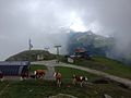
A network of hiking trails and numerous ski lifts open up the Königsleitenspitze, which is part of the Zillertal Arena . Since winter 2011/2012, a gondola lift operated in summer and winter has led from Königsleiten to just below the summit. Three other mountain railways, which operate in winter, also lead close to the summit. These are two gondola lifts and a chair lift .

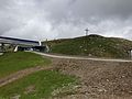
Summit cross in winter

View in winter
Summit in summer
Outlook in summer
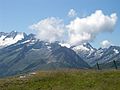
Outlook in summer


Web links
- Hike from Königsleiten via the Larmachalm to the Königsleitenspitze on outdooractive.com - accessed on January 21, 2017
- Hike from the Königsleitenspitze over the Müllachgeier to Königsleiten on outdooractive.com - accessed on January 21, 2017
- Map at peakhunter.com - accessed January 21, 2017