Kaikoura earthquake
| Kaikoura earthquake | ||
|---|---|---|
|
|
||
| Coordinates | 42 ° 41 ′ 2 ″ S , 173 ° 1 ′ 1 ″ E | |
| date | November 14, 2016 | |
| Time | 00:02:56 local time | |
| intensity | 8 on the MM scale | |
| Magnitude | 7.8 | |
| depth | 15 km | |
| epicenter | between Rotherham and Waiau | |
| country | New Zealand | |
| Affected places |
Rotherham , Waiau , Culverden , Hanmer Springs , Kaikoura , Wellington |
|
| Tsunami | Yes | |
| dead | 2 | |

The Kaikoura -Erdbeben on 14 November 2016, the epicenter in the northern region of Canterbury in New Zealand had, according to GNS Science ( GNS Science perceived) has a thickness of 7.8 and was on two main islands of the country in very different ways. In addition to a lot of property damage, tectonic shifts , landslides and a tsunami , two people were killed in the quake. The destruction in the infrastructure of northern Canterbury had been greater than initially assumed. New Zealand accepted offers of help from the United States , Australia , Canada , Japan, and Singapore .
The quake
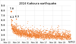
The quake had its hypocenter 5.9 km east of Rotherham and 3.6 km southwest of Waiau at a depth of 15 km and 23 km, respectively, according to the United States Geological Survey (USGS). It was followed by other quakes over a length of around 150 km along the northeast coast of the South Island, which felt like an earthquake over a period of around two minutes. Several faults were involved in the quake, the coastal Kekerengu Fault , the Hope Fault , the Hundalee Fault and a newly identified fault in Waipapa Bay . This mainly affected the northern part of Canterbury and the east coast.
A measuring station, which was located near the epicenter, recorded an acceleration of the ground of up to 1.3 g in the horizontal direction. Another station, which is located in Waiau , had a peak value in the vertical acceleration of 3 g. In comparison, the Christchurch earthquake of February 2011 was 2.2 g.
In terms of its intensity, the earthquake has so far been classified in Category VIII of the Modified Mercalli Scale and in Wellington, around 200 km away, with a strength between VI and VII.
The New Zealand disaster control issued a tsunami warning for all coastal areas of the country immediately after the quake, sirens wailed on the coasts of all parts of the country. A tidal wave had reached 2.6 meters on the east coast.
Effects of the quake
In addition to failures in the power supply, parts of the affected east coast were cut off from communications and numerous road sections on the coast were interrupted by landslides. The Coastal Pacific railroad was also affected. In the first observation flights, the number of landslides is estimated between 80,000 and 100,000. A landslide led to a blockade of the Clarence River , the dam of which the resulting dam gave way the next day and caused a tidal wave.
Most of New Zealand was displaced by the earthquake. The country's GPS measuring stations were able to detect changes in all parts of the two main islands, but especially in the north of the South Island and on the North Island up to Auckland . The largest shift in the horizontal direction recorded the Cape Campbell measuring station of GNS Science in the Marlborough District . It was offset by more than two meters to the north-northeast. In contrast, the highest vertical displacement was documented on the coastal strip of Waipapa Bay . Here the ground rose by around 5.5 m.
Kaikoura
Kaikoura , the largest town in the northern part of the Canterbury region, was cut off from the outside world by the earthquake. Landslides blocked the route of the New Zealand State Highway 1 , as well as the railway routes of the Coastal Pacific to the north and south several times in different places. A branch line that connects to New Zealand State Highway 7 was also no longer passable. All power and telecommunications connections to Kaikoura were also destroyed. The place had to besupplied with food, medicine and other necessitiesby helicopter . Vacationers were evacuated by helicopter and the New Zealand Navy's Canterbury transport. The USS Sampson , a destroyer for the American Navy, actually on its way to a friendship visit to Auckland , changed course in the direction of Kaikoura to provide assistance. Australia also sent the HMAS Darwin and Canada the frigate HMCS Vancouver . The New Zealand Navy also sent ships to ensure supplies to the region.
Wellington
Since the shocks in the region Wellington an acceleration of the substrate caused by up to 0.2 g, were also in Wellington recorded damage. A nine-storey office building in Molesworth St , in the Thorndon district , not far from the National Library of New Zealand , was evacuated and the streets were cordoned off because the building's basic structure was damaged and a collapse could not be ruled out. The Thai embassy across from the building was also closed. The Inland Revenue office building was also evacuated on November 22, 2016 after experts discovered damage to the stairwell, which could no longer guarantee the safety of the building in the event of another significant earthquake.
See also
Web links
- Earthquake: Deaths, major damage after severe 7.5 quake hits Hanmer Springs, tsunami warning issued . In: stuff - national . Fairfax Media, November 14, 2016,accessed November 13, 2016.
- Photos: Large quake strikes New Zealand . In: stuff - national . Fairfax Media, November 14, 2016,accessed on November 13, 2016(English, some photos documenting the damage).
Individual evidence
- ↑ a b New Zealand Earthquake Report - Magnitude 7.8, Mon, Nov 14 2016, 12:02:56 am (NZDT) . In: GeoNet . Institute of Geological and Nuclear Sciences , November 14, 2016, accessed November 23, 2016 .
- ↑ a b Earthquake: Deaths, major damage after severe 7.5 quake hits Hanmer Springs, tsunami warning issued . In: stuff - national . Fairfax Media , November 14, 2016, accessed November 13, 2016 .
- ^ A b Fleet of international warships to help out with earthquake response . The New Zealand Herald , November 15, 2016, accessed November 15, 2016 .
- ↑ M7.8 - 53km NNE of Amberley, New Zealand . United States Geological Survey (USGS), November 13, 2016, accessed November 14, 2016 .
- ↑ Watching the M7.8 Kaikoura Quake Dominos Fall in Real Time . In: GeoNet . Institute of Geological and Nuclear Sciences , accessed November 23, 2016 .
- ↑ M7.8 Kaikoura Earthquake: Latest updates . In: GeoNet . Institute of Geological and Nuclear Sciences , accessed November 23, 2016 .
- ↑ a b Shaking from Kaikoura Earthquake . In: GeoNet . Institute of Geological and Nuclear Sciences , November 21, 2016, accessed November 23, 2016 .
- ↑ LIVE: 7.5 quake near Hanmer rocks whole country . Radio New Zealand , November 14, 2016, accessed November 13, 2016 .
- ↑ Severe aftershocks. ORF, November 14, 2016, accessed on November 14, 2016 .
- ↑ GPS allowed rapid detection of land movements due to M7.8 earthquake . In: GeoNet . Institute of Geological and Nuclear Sciences , accessed November 23, 2016 .
- ^ Coastal Uplift: How has the Kaikoura Coastline Changed . In: GeoNet . Institute of Geological and Nuclear Sciences , November 21, 2016, accessed November 23, 2016 .
- ↑ Watch: Quake damage near Kaikoura . The New Zealand Herald , November 15, 2016, accessed November 15, 2016 .
- ^ Severe earthquake strikes South Island . In: GeoNet . Institute of Geological and Nuclear Sciences , November 14, 2016, accessed November 14, 2016 .
- ^ Serious concerns for building in central Wellington with beam 'like a broken bone' . The New Zealand Herald , November 15, 2016, accessed November 15, 2016 .
- ↑ IRD Wellington headquarters evacuated . The New Zealand Herald , November 23, 2016, accessed November 23, 2016 .


