
Waiau
| Waiau | ||
| Geographical location | ||
|
||
| Coordinates | 42 ° 39 ′ S , 173 ° 2 ′ E | |
| Region ISO | NZ-CAN | |
| Country |
|
|
| region | Canterbury | |
| District | Hurunui District | |
| Ward | Amuri-Hurunui Ward | |
| Residents | 261 (2013) | |
| height | 135 m | |
| Post Code | 7332 | |
| Telephone code | +64 (0) 3 | |
| Photography of the place | ||
 Place with Waiau River and the Lowry Peaks Range in the background |
||


Waiau is a village in the Hurunui District of Canterbury on the South Island of New Zealand .
geography
Waiau is located approximately 23 km southeast of Hanmer Springs , 21 km northwest of Cheviot and 60 km southwest of Kaikoura . The New Zealand State Highway 70 , which connects Culverden in the southwest with Kaikoura in the northeast, runs through the village . West of Waiau the Waiau River runs past the place.
history
In the Cyclopedia of New Zealand from 1903, Waiau , which was founded in the 1870s, is described as a picturesque place, with a hotel, a post and telegraph station, a so-called Money Order Office , two shops, two churches, one School and a library, two carriage stations, a saddler and a blacksmith. The place, which had 153 inhabitants at the time, lived from sheep breeding and flax cultivation .
population
In the 2013 census, the town had 261 inhabitants, 3.6% more than in the 2006 census.
earthquake
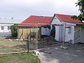
On November 14, 2016, the Kaikoura earthquake , which had its epicenter 3.6 km southwest of Waiau , generated significant damage in the location. Up to 15 buildings, it was estimated a day later, were so damaged that they must be demolished. As an example, the town's All Saint's Church , built of stone and cement, was irreparably damaged. The Waiau Lodge Hotel was also so damaged that it could still not be restored in February 2017. Built in the 1860's Cob Cottage , which the New Zealand Historic Places Trust (NZHPT) under monument protection was provided, was also the earthquake victims. The building of the Presbyterian Church , which stands only a few meters from the cottage , however, remained intact.

Waiau Lodge Hotel

All Saints Church
Cob Cottage
.jpg)
.jpg)
.jpg)
See also
literature
- Waiau . In: The Cyclopedia of New Zealand . The Cyclopedia Company , Christchurch 1903, Canterbury Provincial District , S. 594-596 (English, online [accessed February 7, 2017]).
Individual evidence
- ↑ a b 2013 Census QuickStats about a place : Waiau . Statistics New Zealand , accessed February 7, 2017 .
- ↑ Topo250 maps - Reefton - Wairau River - Lake Sumner . Land Information New Zealand , accessed February 7, 2017 .
- ↑ Kurt Bayer: Kaikoura quake: Up to fifteen buildings in Waiau set to be demolished . The New Zealand Herald , November 15, 2016, accessed February 7, 2017 .