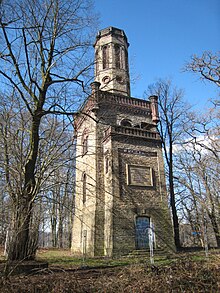
Kaisberg

The Kaisberg is a 185 m high hill east of the Harkortsee north of Hagen-Vorhalle . The layers of carbon that form the ridge of the mountain are among the deepest Sprockhövel layers , the lower Sengsbank seam to the oldest coal-bearing layers (seam-bearing upper carbon) in the Ruhr area . The sandstone is eponymous for the Kaisberg formation.
They say stories that once the Roman general Varus in the year 9 and centuries later the Great Charles at the siege of Saxon Sigiburg have stored 775 here.
In 1876, while building the Volmetalbahn , workers discovered three bronze long swords from the Bronze Age and Urnfield Culture near the Kaisberg.
The sights of the hiking trails include the Freiherr vom Stein tower on the mountain itself, the Kaisberg tunnel at the foot of the mountain and, to the southwest of the Kaisberg, the Werdringen moated castle with the museum for prehistory and early history . Directly to the north there is a sewage treatment plant in the Ruhr floodplains and due to the application of sewage sludge, some surrounding areas are cadmium-contaminated .
A group of scientists from the Karl Ernst Osthaus Museum investigated from 2000 to 2002 as part of the Ruhr Landscape Park project how the landscape on the Kaisberg can be improved and at the same time made more accessible.
Starting in 2005, based on the neighboring Museum of Prehistory and Early History , there are plans for an evolution park in Hagen , which will also include the Kaisberg in the concept. The Kaisberg geological path, a geological path around the mountain , has been implemented so far .
The northeast slope of the Kaisberg lies in the nature reserve of the former Harkortsee marina .
View from the weather castle
literature
- Albrecht Jockenhövel: The sword hoard from Kaisberg near Hagen-Vorhalle. Technological investigations on three late Bronze Age swords from the hoard of Hagen-Kaisberg. In: Archaeological contributions to the history of Westphalia, Rahden / Westf., 1997, pp. 133–154
- Detlev Rohe: Cultural influences of prehistoric finds from the estuary of Ennepe, Volme and Lenne online
- Michael Fehr, Falk Wolf (eds.): Landschaftsbauhütte Ruhrtal. An artistic-scientific report on the Kaisberg in Hagen. Essen: Klartext Verlag , 2002, ISBN 3-89861-117-5
- Heinrich Leipold: Hikes through the Ennepe-Ruhr district. H. 2. From the Ardey to the Kaisberg. Baltin publishing house. 1958
Web links
Individual evidence
- ↑ https://www.botanik-bochum.de/exkursionen/Exkursion110409HagenKaisberg.htm
- ↑ https://www.botanik-bochum.de/jahrbuch/Exkursion_110409_HAKaisberg.pdf
- ↑ http://www.metropoleruhr.de/geopark/georoute-ruhr/geopfad-kaisberg.html
Coordinates: 51 ° 23 ' N , 7 ° 26' E

