Kalogeri
| Kalogeri | ||
|---|---|---|
| Representation by Francis Beaufort , 1812 | ||
| Waters | Aegean Sea | |
| Geographical location | 38 ° 10 ′ N , 25 ° 17 ′ E | |
|
|
||
| Number of islands | 2 | |
| Main island | Megalos Kalogeros | |
| Total land area | 0.006 km² | |
| Residents | uninhabited | |
|
Benedetto Bordone : Caloiero, woodcut from 1537 |
||
The Kalogeri ( Greek Καλόγεροι [ kaˈlɔʝɛri ] ( m. Pl. ), Monks') are two rocky islands in the geographical center of the Aegean . They belong to the municipality and island of Andros in the Greek region of South Aegean , the northernmost point of which they form. The closest islands are Andros (around 42 km southwest), Andipsara (around 45 km northeast) and Chios (around 52 km east).
geography
The names of the individual rocks are Megalos Kalogeros (Μεγάλος Καλόγερος, 38 ° 09 '54 " N , 025 ° 17' 00" O ) and the approximately 1400 meters northeast lying microphones Kalogeros (Μικρός Καλόγερος, 38 ° 10 '23 " N , 025 ° 17 ′ 28 ″ O ). Megalos Kalogeros rises 36 meters above sea level and covers around 0.6 hectares , Mikros Kalogeros is much smaller and only one meter high. The rocks are of volcanic origin and practically devoid of vegetation.
Megalos Kalogeros rises steeply from the approximately 200 m deep seabed, undersea rocks make the bypass very dangerous, only in the southwest there is an anchorage possible in calm weather.
history
Megalos Kalogeros is possibly the island of Aix ( ancient Greek Αἴξ 'goat' , Latin Aex ) described by Pliny the Elder , which he locates between Tinos and Chios ( Nat. Hist. IV 51). The first modern mention was made by Cristoforo Buondelmonti in 1420 as Caloerus, which, similar to Pliny, is described as a solitary, rugged and inaccessible rock, on which ships often crashed. A second island with this name is located in Buondelmonti near Kos .
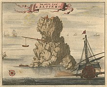
The cartographers of the following centuries mixed up the information about these two islands, but mostly located Caloiero at the location of the second island mentioned by Buondelmonti between Amorgos and Kos or west of Nisyros - this may have meant today's Kandeliousa , which is much flatter and far more accessible . The descriptions and pictures of this rocky island all show a small monastery on top and a crane with which a boat is lifted out of the sea. From around 1700 these signs of settlement on the rock have disappeared from the images.
The British author Bernard Randolph provided an explanation for this: In 1687, in his work The Present State of the Islands in the Archipelago (Oxford 1687), he wrote that he had learned from traders in Smyrna that an island called Kalogeros between Chios and Andros had been caused by an explosion destroyed and all its inhabitants and their property perished. Only a small part of the original island was left. In fact, history only records eruptions around the volcanoes of Santorini , Methana and Nisyros around 1650 . A volcanic activity at the site of today's Kalogeri has not yet been proven.
In 1920 the first lighthouse was built on the rock, which is close to important sea routes. A barrack was built next to it. In 1940 six residents were recorded on the rock, possibly members of the Greek Navy. The German occupiers built arms stores and water reservoirs, the ruins of which can be seen today on the slope of the rock. A weathered stone staircase carved into the rock in the east and a few steel ladders anchored in the stone enable the ascent to the top to this day. A steel lighthouse is now operated by the Greek Navy, from which the batteries and other moving parts were removed by thieves in November 2006.
In the course of the dispute between Greece and Turkey over the use of the Aegean continental shelf and the definition of the sea and the boundaries of the respective airspace, the rocks play a certain role. From the 1990s onwards, Turkish politicians declared all islands and rocks not specifically assigned to Greece in international treaties to be a “gray area” under international law and questioned whether the Kalogeri belong to Greece. In July 2003, for example, the Turkish Navy sent a ship to the Central Aegean to investigate the continental shelf around the Kalogeri. The ship advanced far to the south and came precariously close to a maneuver by the Greek Navy, which was held in the maneuver area LDG-68, which also includes the rocky islands. This led to internal Greek disputes, particularly between the Ministry of Foreign Affairs, which declined to respond, and the Greek Navy.
literature
- W. Sidney Allen: Kalóyeros: An Atlantis in microcosm ?, in: Imago Mundi, 29: 1, pp. 54-71 (1977)
Web links
- Βραχονησίδες Καλόγεροι: To “κλειδί” του Κεντρικού Αιγαίου - report on the islands
- Portrait of the rocks on ribandsea.com (Greek)


