Cape Herlacher
| Cape Herlacher | ||
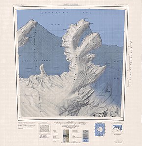
 Topographic map of the Martin Peninsula with Cape Herlacher (above) |
||
| Geographical location | ||
|
|
||
| Coordinates | 73 ° 52 ′ S , 114 ° 12 ′ W | |
| location | Marie Byrd Land , West Antarctica | |
| coast | Bakutis coast | |
| Waters | Amundsen lake | |
| Waters 2 | Glade Bay | |
Cape Herlacher is a massive and ice-covered cape on the Bakutis coast of the West Antarctic Marie Byrd Land . It represents the northern end of the Martin Peninsula .
An initial mapping was made using aerial photographs taken in January 1947 as part of Operation Highjump (1946–1947). The Advisory Committee on Antarctic Names named the cape after Carl John Herlacher (1895–1975), chief Antarctic cartographer of the United States Hydrographic Office in 1937.
Web links
- Cape Herlacher in the Geographic Names Information System of the United States Geological Survey (English)
- Cape Herlacher on geographic.org (English)
