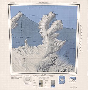
Martin Peninsula
| Martin Peninsula | ||
 Topographic map sheet Martin Peninsula 1: 250,000 |
||
| Geographical location | ||
|
|
||
| Coordinates | 74 ° 15 ′ S , 114 ° 30 ′ W | |
| location | Bakutis Coast , Marie Byrd Land , West Antarctica | |
| Waters 1 | Getz Ice Shelf , Amundsen Lake | |
| Waters 2 | Dotson Ice Shelf | |
| length | 90 km | |
| width | 35 km | |
The Martin Peninsula ( Martin Peninsula ) is an approximately 90 km long and 35 km wide Antarctic Peninsula . It is located on the Bakutis coast of Marie Byrd Land in West Antarctica between the Getz Ice Shelf in the west and the Dotson Ice Shelf in the east, two smaller Antarctic ice shelves . In the north it rises in the form of Cape Herlacher into the sometimes ice-free waters of the Amundsen Sea . The northern third of the almost completely glaciated peninsula is divided into two larger parts by the fjord-like Philbin Inlet - the Slichter Foreland and the Murray Foreland with the northernmost point of the peninsula, Cape Herlacher. The Kohler Range connects to the Martin Peninsula in the south .
The Martin Peninsula was first mapped in 1947 as part of Operation Highjump . The peninsula was named after Lawrence Martin, an American officer.
Web links
Individual evidence
- ↑ Archived copy ( Memento from September 26, 2007 in the Internet Archive )
