Slight Foreland
| Slight Foreland | ||
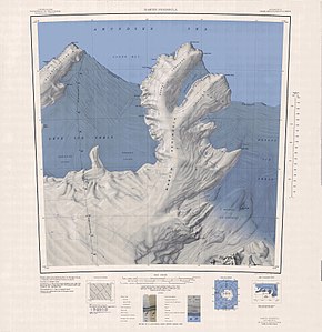
 Topographic map of the Martin Peninsula with the Slichter Foreland (top right) |
||
| Geographical location | ||
|
|
||
| Coordinates | 74 ° 7 ′ S , 113 ° 55 ′ W | |
| location | Walgreen Coast , Marie Byrd Land , West Antarctica | |
| Waters 1 | Amundsen lake | |
| Waters 2 | Philbin Inlet | |
| Waters 3 | Singer Glacier | |
| Waters 4 | Dotson Ice Shelf | |
| length | 24 km | |
| width | 16 km | |
The Slichter Foreland is an icy, 24 km long and 16 km wide peninsula on the Walgreen coast of the west Antarctic Marie-Byrd-Land . It forms the northeast branch of the Martin Peninsula .
The United States Geological Survey first mapped the headland using aerial photographs taken by the United States Navy during Operation Highjump (1946–1947) in January 1947. The Advisory Committee on Antarctic Names named it after the US physicist Louis B. Slichter (1896– 1978) from the University of California, Los Angeles , who was entrusted with the development of the scientific program for the Amundsen-Scott South Pole Station and the training of a number of dedicated geophysicists .
Web links
- Slichter Foreland in the Geographic Names Information System of the United States Geological Survey (English)
- Slichter Foreland on geographic.org (English)
