Cape Leeuwin
Coordinates: 34 ° 22 ′ 35.7 ″ S , 115 ° 8 ′ 11 ″ E
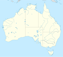
Cape Leeuwin , English Cape Leeuwin , (pronunciation 'luwɪn , ) is the southwesternmost point of mainland Australia . It is located in the state of Western Australia , about seven kilometers south-southwest of Augusta and about 277 kilometers south-southwest of Perth . The name of the cape probably comes from the Dutch word leeuwin for "lioness" (see story).
Although Cape Leeuwin is not the southernmost point of Australia (see South Point and Southeast Cape ), with the Cape of Good Hope and Cape Horn it is considered one of the three "big" capes of the southern hemisphere and a symbolic waypoint for reaching or passing Australia for ocean shipping to or from the open Indian Ocean.
location
Cape Leeuwin is the southern headland on an anvil- shaped peninsula, the northern tip of which is the Cape Naturaliste (formerly also the natural scientist's cape ). The peninsula is also referred to in tourist brochures as Cape to Cape (from Cape to Cape) or the Capes (the Cape) after the two capes . Since 2001 there has also been a 135-kilometer hiking trail between the two capes, the so-called Cape to Cape Track , which runs from the lighthouse at Cape Leeuwin to the lighthouse at Cape Naturaliste. The Leeuwin Naturaliste National Park is located on the peninsula , one of the best-visited national parks in Australia.
To the east, Cape Leeuwin is followed by the Flinders Bay, named after Matthew Flinders , on the northern coast of which is Augusta, the settlement closest to the Cape. To the southeast the bay is bounded by D'Entrecasteaux Point .
Cape Leeuwin is sometimes shown as the border point between the Indian and Southern Oceans ( Southern Ocean ), for example on a notice board at the Cape (see picture on the right). In general, however , the term Southern Ocean is only used for waters south of the 60th parallel - about 2850 kilometers further south than Cape Leeuwin. Accordingly, the sea in the south of Australia - west of the southeastern cape on Tasmania - is usually included in the Indian Ocean (see for example on the map of the CIA World Factbook at the top right).
history
The cape was referred to as t landed Leeuwin on early Dutch maps around 1622 . This suggests that the cape was sighted from the Dutch ship De Leeuwin ( Dutch for "the lioness"). In the years that followed, it was seen by many Dutch, French and English explorers. These included:
- 1627 François Thijssen on the Gulden Zeepaard
- 1772 Louis Francois Marie Alesno de St Allouarn on the Gros Venture
- 1791 George Vancouver on the 1789 built HMS Discovery (named after James Cook's ship)
- 1801, May 27th, Nicolas Baudin on Le Géographe , his second ship was Le Naturaliste ; Baudin called the Cape Cape Gosselin , but the name didn't catch on.
- 1801 December 6th Matthew Flinders on the HMS Investigator
In 1830 the area around the cape was settled.
The Cape Leeuwin Lighthouse
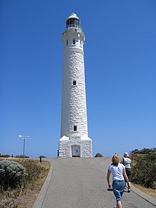
The Cape Leeuwin Lighthouse ( Cape Leeuwin Lighthouse ) and the buildings surrounding it were built from 1895-1896 in local limestone. The tower was inaugurated in 1895 by the Australian explorer and politician John Forrest , and the fire was lit for the first time on December 1, 1896.
Originally, a second, smaller, red tower was planned in front of the 39 meter high, white tower. The foundation of the tower was laid, but construction was not continued, as it was feared that a second light would only confuse shipping and lure ships closer to the coast.
The light source of the lighthouse fire was originally a kerosene wick lamp, at that time the world's largest rotating lamp in a mercury bath. In 1925 they switched to oil vapor and in 1982 to electricity. In 1992 operations were automated. The lighthouse has an identifier of a lightning bolt in 7.5 seconds. Its fire, installed at a height of 56 meters (above sea level), has a range of 25 nautical miles (approx. 46 kilometers) with a light intensity of one million candela (CD ).
The lighthouse serves as a navigation mark and is also a - meanwhile also automated - weather station. In the 1960s, a telecommunications tower was built in the northwest of the lighthouse, and in the 1980s the system was expanded to two telecommunications towers. In the meantime the telecommunication towers have been removed again.
The lighthouse has seven floors and 186 steps. It's painted white; it used to be beige at times. The lighthouse and its surroundings are open to visitors.
Individual evidence
- ↑ a b c The Cape Leeuwin Lighthouse. History , on the website Lighthouses of Australia Inc ( Memento from March 1, 2014 in the Internet Archive ) (English; accessed April 8, 2007)
Web link
- Cape Leeuwin lighthouse ( memento from March 1, 2014 in the Internet Archive ) (with photos including an aerial view of the cape)


