Leeuwin Naturaliste National Park
| Leeuwin Naturaliste National Park | ||
|---|---|---|
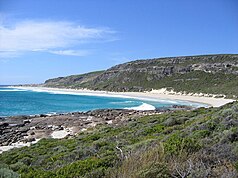
| Coast of the Leeuwin Naturaliste National Park | ||
|
|
||
| Location: | Western Australia , Australia | |
| Specialty: | Caves and forests | |
| Next city: | 10 km from Augusta | |
| Surface: | 156 km² | |
| Founding: | 1957 | |
| Visitors: | 1.9 million (2004) | |
| Near the lighthouse at Cape Leeuwin | ||
The Leeuwin Naturaliste National Park is a 156 km² park in the southwest of Western Australia , Australia .
location
The park is about 270 km south of Perth . The Bussell Highway and Caves Road are accessible from the nearby towns of Busselton , Margaret River and Augusta .
The Leeuwin-Naturaliste-Ridge range extends for 100 km along the coast of the Indian Ocean . Its name goes back to the two headlands at opposite ends: Cape Leeuwin in the south , which is the most south-westerly point of the Australian mainland, and Cape Naturaliste in the north . Between these two capes , the coast runs almost exactly in a north-south direction. The national park stretches almost continuously along the entire coastline, whereby it is partly very narrow, partly extends up to ten kilometers into the hinterland.
park
Rugged cliffs, headlands made of granite and striking rock formations such as the Canal Rocks or the Sugarloaf Rock determine the coast of the national park. Humpback whales and southern right whales can be observed from various vantage points .
The main attractions in the park, however, are the caves , of which over 100 have been discovered in the limestone cliffs to date . Their dimensions range from narrow tunnels to glacier pots to large caves 14 km in length. Some caves offer guided tours ( Jewel Cave, Lake Cave, Mammoth Cave and Moondyne Cave ), others you can explore on your own ( Calgardup and Giants Cave ).
Further inland - for example in the Boranup Karri Forest - one can find stands of old, up to 60 m high Karri ( Eucalyptus diversicolor ) and "Jarrah" forests ( Eucalyptus marginata ). As you can find it today, the forest is around 100 years old. The old stock was cleared by the timber industry, the last sawmill near Karridale closed in 1913.
In 2001, the Department of Environment and Conservation opened the Cape to Cape Track , a 135 km long hiking trail along the Leeuwin Naturaliste Ridge.
Individual evidence
- ↑ Management plan. (pdf) (No longer available online.) DEC , 2005, pp. 2–3 , formerly in the original ; accessed on June 17, 2009 . ( Page no longer available , search in web archives ) Info: The link was automatically marked as defective. Please check the link according to the instructions and then remove this notice.
- ↑ Australia Easy Read - Road and 4WD Atlas . Hema Maps, Brisbane 2007, ISBN 978-1-86500-395-5 .
- ↑ a b Official website of the park. DEC , accessed June 26, 2009 .
- ^ Margaret River Region Caves. Margaret River Busselton Tourism Association (MRBTA), accessed January 28, 2017 .
- ^ Otmar Lind, Andrea Niehues: Australia - The most beautiful national parks . Edgar Hoff Verlag, Rappweiler 1995, ISBN 3-923716-12-5 .
- ↑ Track Facts. (No longer available online.) Friends of the Cape to Cape Track, archived from the original on December 6, 2010 ; accessed on June 26, 2009 . Info: The archive link was inserted automatically and has not yet been checked. Please check the original and archive link according to the instructions and then remove this notice.
Web links
- Official site of the park (English)
- DEC : Management Plan (English; PDF; 429 kB)
- Friends of the Cape to Cape Track website


