D'Entrecasteaux National Park
| D'Entrecasteaux National Park | ||
|---|---|---|
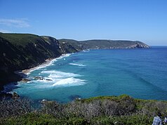
| Coast at Long Point | ||
|
|
||
| Location: | Western Australia , Australia | |
| Specialty: | Coastal landscape with cliffs, eucalyptus forest, savanna, wetlands | |
| Next city: | Walpole | |
| Surface: | 1,167 km² | |
| Length: | 130 km | |
| Founding: | 1980 | |
| Visitors: | 137,000 (2009/10) | |
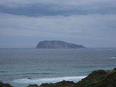
| Chatham Island from Long Point | ||
The D'Entrecasteaux National Park is a 1,200 sq km large park in the southwest of Western Australia , Australia .
location
From Black Point near Augusta , the national park stretches for 130 km along the coast to Long Point near Walpole . It extends up to 20 km inland. To get to the beaches along the coast, you usually need a four-wheel drive vehicle . Only Windy Harbor and Broke Inlet can be reached by normal vehicles. The Donnelly , Warren and Shannon Rivers flow through the park .
history
It is believed that Aboriginal people colonized southwestern Western Australia as long as 47,000 years ago. The oldest archaeological finds in the park can be dated to an age of 6,000 years. In many places in the park there are stone artifacts, references to burial sites and mythologically significant places of the Australian natives.
The national park bears the name of the French navigator and explorer Admiral Joseph Bruny d'Entrecasteaux , who explored the area of today's national park in 1792 and named Point D'Entrecasteaux .
park
Six different landforms can be identified in the park:
- Forest, characterized by tall specimens of the Karri ( Eucalyptus diversicolor ) and the "Jarrah" tree ( Eucalyptus marginata )
- Savannah, with “peppermint” tree ( Eucalyptus dives ) and Banksia species
- Coastal thicket
- Wetlands and swamps
- Coast, with
- Limestone and basalt cliffs such as Point D'Entrecasteaux, Cliffy Head and Black Point
- extensive shifting dunes such as Yeagerup, Callcup, Meerup and Doggerup
- wide beaches and foredunes
- Inselbergs like Mount Chudalup and Pingerup
Flora and fauna
In the national park there are 20 mammals, at least 120 birds, 28 reptiles and 15 amphibians.
Web links
- Official website of the park. DEC , accessed January 16, 2016 .
- Shannon and D'Entrecasteaux National Parks: Management Plan No. 71 (PDF) DEC , 2012, accessed on January 16, 2016 .
Individual evidence
- ↑ Shannon and D'Entrecasteaux National Parks: Management Plan No. 71. (PDF) DEC , 2012, p. 84 , accessed on January 16, 2016 (English).
- ↑ Australia Easy Read - Road and 4WD Atlas . Hema Maps, Brisbane 2007, ISBN 978-1-86500-395-5 .
- ↑ a b Official website of the park. DEC , accessed January 16, 2016 .
- ↑ Shannon and D'Entrecasteaux National Parks: Management Plan No. 71. (PDF) DEC , 2012, p. 18 , accessed on January 16, 2016 (English).
- ↑ Shannon and D'Entrecasteaux National Parks: Management Plan No. 71. (PDF) DEC , 2012, p. 32 , accessed on January 16, 2016 (English).


