Cape Range National Park
| Cape Range National Park | ||
|---|---|---|
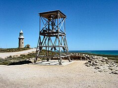
| Lighthouse and gun from World War II at the north end | ||
|
|
||
| Location: | Western Australia , Australia | |
| Specialty: | Coastal landscape | |
| Next city: | Exmouth | |
| Surface: | 505.81 km² | |
| Founding: | 1965 | |
The Cape Range National Park is a national park in Western Australia , 1,105 kilometers north of Perth . The park has a size of 506 km² and is located in the west of the North West Cape peninsula . Most of the vegetation consists of bushland . The many termite mounds standing close together are striking .
The park has several designated trails , in particular by the numerous gorges ( Gorge ) lead. Most of the streets and paths in the park are unpaved. Camping is permitted in designated areas.
The closest town is Exmouth . Just off the western coast is the Ningaloo Reef .
Web links
Commons : Cape Range National Park - Collection of Images, Videos, and Audio Files
- Official website (English)
- Exmouth Visitor Center (English)
- Photo gallery: Cape Range National Park (German)


