Nambung National Park
| Nambung National Park | ||
|---|---|---|
| Pinnacles | ||
|
|
||
| Location: | Western Australia , Australia | |
| Specialty: | Dunes, pinnacles (limestone pillars) | |
| Next city: | Lancelin | |
| Surface: | 184 km² | |
| Founding: | 1968 | |
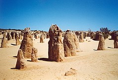
| Pinnacles Lookout: View over the Pinnacles Desert and Banksia bushland to the coast near Cervantes | ||
| Pinnacles | ||
Near the Western Australian town of Cervantes is located Nambung National Park (Engl. Nambung National Park ). It extends 245 km north of Perth along the Swan Coastal Plain . It is an IUCN Category II park and is managed by the Department of Conservation and Land Management .
The main attraction of the national park are the weathered limestone pillars, the "Pinnacles", which are up to four meters high; it is therefore also known under the name Pinnacles Desert , which only makes up a four square kilometer part of the national park.
landscape
The national park lies in a three-part dune system; these dunes mark the former coastlines of the Indian Ocean .
The youngest line, which is closest to the sea, are the Quindalup shifting dunes made of white, limestone-rich sand. They are surrounded by heather vegetation with purple blooming ground cover ( blue fanflower, pigface ).
The second system further inland are the Spearwood Dunes. Yellowish-brownish quartz sand overlays the older limestone of the solidified former dunes. In this system the pinnacles were created . The dune area is surrounded by the Banksia and Dryandra bushes.
The third, oldest, and furthest line of dunes from the sea are the Bassendean woodlands . Shrub-high banksia and tuarts , a small eucalyptus species, grow on the sand, which is rich in silicon .
Wildlife
Most of the animal species in the Nambung National Park are nocturnal. The gray giant kangaroo and emu ( Dromaius novaehollandiae ) are also occasionally seen during the day.
The pine cone skink and the poisonous western brown snake are common among reptile species . The carpet python is rarer in the inaccessible bush areas of the national park .
Over 90 species of birds are native to the Swan Coastal Plain, such as the blue-breasted easel tail , the whistled honey-eater , the wedge-tailed eagle and the Australian gliding hair .
The Pinnacles
The characteristic limestone columns that dominate the middle dune segment were created by vegetation around 500,000 to 50,000 years ago on the quartz sand shifting dune. Its roots penetrated deep into the older, simultaneously solidifying Tamala limestone layer. In the process, they first broke through an extremely hard limestone crust in fragile places, which was created by acids (formed from humus, dead plants and animals) seeping down. Under this crust, the limestone solidified particularly compactly between the penetrated plant roots, as these areas absorbed a lot of water.
The quartz sand-containing shifting dune moved about 2.5 m annually, the exposed limestone layer was exposed to erosion, the vegetation that had died within the last 20,000 years left gaps in which quartz sand penetrated, which was then removed. Only the extremely hard areas of the limestone layer cemented by a lot of water were not affected by the erosion. We see these today as Pinnacles . Occasionally, caps on the pillars are evidence of the crust.
Where the subterranean vegetation was completely enclosed by hard, erosion-proof limestone, petrified plant roots developed.
An approx. 4 km long sand runway opens up the area; an elevated viewing point ( Pinnacles Lookout ) provides an overview of the differently designed smaller and larger formations.
Access
Until September 2010, the national park could only be reached with normal vehicles from the north via Cervantes. The approach from the south via Lancelin and Gray was only possible with an all-wheel drive vehicle. It took at least three hours for the partly sandy, partly rocky and around 65 kilometers long slope with some climbs. It was necessary to adjust the tire pressure to the terrain several times.
In autumn 2010, the asphalting of Indian Ocean Drive between Lancelin and Cervantes was completed, making it easier and more interesting for tourists to access the park.
literature
- Günther, Janine / Mohr, Jens: Westaustralien und das Top End, Verlag 360 °, 1st edition 2005
Web links
Individual evidence
- ^ Indian Ocean Drive. (No longer available online.) In: Main Roads Western Australia. October 2010, archived from the original on September 18, 2010 ; accessed on November 5, 2010 (English). Info: The archive link was inserted automatically and has not yet been checked. Please check the original and archive link according to the instructions and then remove this notice.
- ^ Last link in Indian Ocean Drive coastal road open. In: Government of Western Australia. September 19, 2010, accessed November 5, 2010 .


