Eucla National Park
| Eucla National Park | ||
|---|---|---|
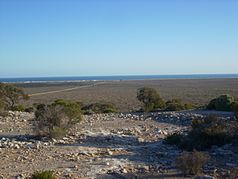
| View from the approximately 200 m high Eucla Pass towards the coast | ||
|
|
||
| Location: | Western Australia , Australia | |
| Specialty: | Sand dunes | |
| Next city: | Eucla , Ceduna , Norseman | |
| Surface: | 33 km² | |
The Eucla National Park is located in Western Australia , Australia . The park is 714 kilometers east of Norseman and 493 kilometers west of Ceduna on the Eyre Highway , which runs along the northern border of the national park. The park is about two kilometers southeast of the small town of Eucla , between the highway and the coast. It is only accessible by four-wheel drive vehicles . On the edge of the Nullarbor desert location, the park is immediately adjacent to the to South Australia belonging Nullarbor National Park .
The 33-square-kilometer Eucla National Park in addition to the sand dunes by Mallee - and Mulgabuschland marked. It protects an area characterized by sand dunes. Spring flowers bloom in spring. That is why it is especially popular with tourists during this time. From Wilson Bluff and the Delisser sand dunes to look at the cliffs is limestone on the coast of the Great Australian Bight possible.
In the Eucla National Park there is a telegraph and weather station from the time of the European colonization of Australia, which had to be abandoned, covered by wandering sand dunes . These buildings in the south of the park can be reached on a path. There are no tourist facilities in the park.

