Greater Beedelup National Park
| Greater Beedelup National Park | ||
|---|---|---|
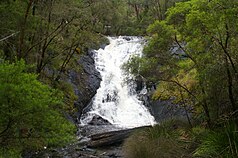
| Beedelup waterfall | ||
|
|
||
| Location: | Western Australia , Australia | |
| Specialty: | Large karri trees up to 90 meters high and a waterfall | |
| Next city: | Pemberton (Australia) | |
| Surface: | 18 km² | |
| Founding: | 1977 | |
The Greater Beedelup National Park is a national park in the Australian state of Western Australia , 367 kilometers south of Perth . The park is about 14 miles west of Pemberton .
Surname
The name is borrowed from Beedelup Brook , a name for a stream. The local Aborigines of the Noongar , the traditional owners of this area, use beedelup for a place to sleep or for a quiet area.
tourism
The main attraction of the park is the 100 meter high Beedelup Falls , which falls over granite rock and forms the Beedelup Brook . However, the stream does not carry water all year round. In 1995 a suspension bridge was built over the Beedelup Falls . But there is also a viewing platform that allows a view over the waterfall.
The park is wooded. Mainly karri trees grow in it up to a height of 90 meters. But there are also jarrah and marri trees . The forest floor is covered with large colonies of moss, on which bushes and small trees also grow.
Through the national park runs part of the Karri Forest Explorer Drive , a 85-kilometer drivable path that also leads to the Gloucester Tree , Dave Evans Bicentennial Tree , Gloucester National Park , the Cascades , Warren National Park , Warren River and the Big Brook Dam leads.
Web links
Individual evidence
- ↑ a b Greater Beedelup National Park , on dpaw.wa.gov.au. Retrieved August 22, 2017

