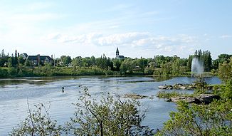
Kapuskasing River
| Kapuskasing River | ||
|
Kapuskasing River in Kapuskasing |
||
| Data | ||
| location | Algoma District and Cochrane District in Ontario, Canada | |
| River system | Moose River | |
| Drain over | Mattagami River → Moose River → James Bay | |
| origin |
Kapuskasing Lake 48 ° 29 ′ 1 ″ N , 82 ° 56 ′ 40 ″ W. |
|
| Source height | 312 m | |
| muzzle | in the Mattagami River coordinates: 49 ° 48 ′ 30 " N , 82 ° 0 ′ 9" W 49 ° 48 ′ 30 " N , 82 ° 0 ′ 9" W |
|
| Mouth height | 195 m | |
| Height difference | 117 m | |
| Bottom slope | approx. 0.65 ‰ | |
| length | approx. 180 km | |
| Discharge at the Kapuskasing A Eo gauge : 6760 km² |
MQ 1918/1993 Mq 1918/1993 |
77 m³ / s 11.4 l / (s km²) |
| Left tributaries | Lost River , Dunrankin River | |
| Right tributaries | Remi River , Saganash River , Nemegosenda River | |
| Small towns | Kapuskasing | |
|
Kapuskasing River in Kapuskasing |
||
Kapuskasing River is a river in the Canadian province of Ontario .
The river has its origin in Kapuskasing Lake in the Algoma District . From there it flows in a north-northeast direction. It passes the city of Kapuskasing named after him and flows into the Mattagami River after about 180 km from the left .
Hydropower plants
Four hydropower plants are under construction south of Kapuskasing: Old Woman Falls , White Otter Falls , Camp Three Falls and Big Beaver Falls . The power plants each have an output of 5.5 MW.
The construction of four hydropower plants ( Kapuskasing Lake Outlet , Lapinigam Rapids , Middle Township Buchan (Clouston Rapids) , Near North Boundary (Cedar Rapids) ) with a total output of 19.45 MW is being investigated on the course of the river north of Kapuskasing Lake .
Web links
Individual evidence
- ↑ Kapuskasing River at the Kapuskasing gauge - hydrographic data at R-ArcticNET
- ↑ Hydromega: Kapuskasing - North Water Power Project
- ↑ Xeneca Power Development Inc. - Kapuskasing River

