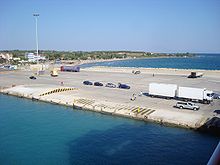
Kastro-Kyllini
|
Kastro-Kyllini municipality Δημοτική Ενότητα Κάστρου-Κυλλήνης (Κάστρο-Κυλλήνη) |
||
|---|---|---|
|
|
||
| Basic data | ||
| State : |
|
|
| Region : |
West Greece
|
|
| Regional District : | Elis | |
| Municipality : | Andravida-Kyllini | |
| Geographic coordinates : | 37 ° 56 ' N , 21 ° 9' E | |
| Height above d. M .: | 1-200 m (average) |
|
| Area : | 49.322 km² | |
| Residents : | 3,622 (2011) | |
| Population density : | 73.4 inhabitants / km² | |
| Code No .: | 390304 | |
| Structure: | 4 local communities | |
| Located in the Andravida-Kyllini municipality and the Elis regional district | ||
Kastro-Kyllini ( Greek Κάστρο ( n. Sg. ) - Κυλλήνη ( f. Sg. )) Was from 1997 to 2010 a municipality in the prefecture of Elis in the northwest of the Greek peninsula Peloponnese . The administrative seat was the small port town of Kyllini . Other districts of the community were Kato Panagia , Kastro and Neochori. The municipality comprised the western part of the Kyllini peninsula. The peninsula on the Ionian Sea is the westernmost part of the Peloponnese. The coast is characterized by a sandy beach stretching for many kilometers. This makes the area very popular with domestic and foreign guests.
In 2010, Kastro-Kyllini was merged with Andravida , Lechena and Vouprasia to form the new municipality of Andravida-Kyllini , where it has since formed a municipality.
Administrative division
The municipality is divided into four local communities.
| Local community | Greek name | code | Area (km²) | 2001 residents | Residents 2011 | Villages and settlements |
|---|---|---|---|---|---|---|
| Kyllini | Τοπική Κοινότητα Κυλλήνης | 39030401 | 4,750 | 1079 | 631 | Kyllini, Kafkalida |
| Kastro | Τοπική Κοινότητα Κάστρου | 39030402 | 26,798 | 930 | 1089 | Kastro, Analipsi, Kalamia, Karavaki, Loutra Kyllinis, Psili Rachi |
| Kato Panagia | Τοπική Κοινότητα Κάτω Παναγίας | 39030403 | 7.450 | 1313 | 1149 | Ikaros, Kato Panagia, Moni Vlachernon |
| Neochori | Τοπική Κοινότητα Νεοχωρίου Μυρτουντίων | 39030404 | 10,324 | 1164 | 753 | Neochori, Vytinaiika |
| total | 390304 | 49,322 | 4486 | 3622 | ||
Kyllini
Kyllini ( Greek Κυλλήνη , earlier spellings Cyllene or Kyllênê ) is the administrative center. The port city is a center with schools, banks and tourist infrastructure, mainly because of the port. The port is particularly important for passenger shipping, as ferries lead from here to the islands of Zakynthos and Kefalonia . A previous railway line to the port has been closed and is no longer used.
Kato Panagia
Kato Panagia ( Greek Κάτω Παναγιά ) is only 1 km from Kyllini.
Kastro
Kastro ( Greek Κάστρο ) is a village in the center of the Kyllini peninsula. With 800 inhabitants, the place offers all important tourist infrastructure facilities.
Loutra Kyllinis
The warm springs of Kyllini can be found in the village of Loutra Kyllinis ( Greek Λούτρα Κυλλήνης ). This is located in the southwest of the peninsula. Hotel and spa facilities have been built around the warm springs.
Chlemoutsi fortress
The Chlemoutsi Castle stands on a hill near Kastro at an altitude of around 200 m . It was built in 1218–1223 under the rule of Gottfried II von Villehardouin the prince of Achaia . The fortress is a dominant feature of the peninsula that can be seen from afar.
Web links
- Kastro Official Site (English)
Individual evidence
- ↑ Results of the 2011 census. ( Memento from June 27, 2015 in the Internet Archive ) ( MS Excel ; 2.6 MB) Greek Statistical Office (ΕΛ.ΣΤΑΤ)


