Kattstein
| Kattstein | ||
|---|---|---|
|
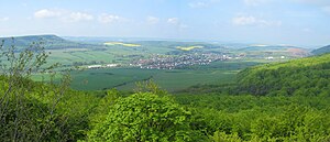
The Kattstein (left) seen from the opposite Gebraer head |
||
| height | 460 m | |
| location | Nordhausen district , Thuringia | |
| Mountains | Thin | |
| Coordinates | 51 ° 24 '0 " N , 10 ° 32' 52" E | |
|
|
||
| rock | Lower Muschelkalk | |
The Kattstein (also Katzenstein ) is an approximately 460 m high mountain in the Nordhausen district in northern Thuringia ( Germany ).
location
The Kattstein is a northern branch of the 485 m high war mountain northeast of Rehungen , south of Sollstedt and north of Friedrichsrode , the district town of Nordhausen is about 20 kilometers to the northeast.
The mountain forms an approximately 90 ° bend at the level of the Dün at the transition to the Hainleite within the northwestern edge plates of the Thuringian basin . For the boundary between Dün and Hainleite, see the corresponding section in the Hainleite article .
particularities
The name probably derives from the Germanic tribe of the chat off the northeastern border there was possibly here. Other field names refer to this, such as B. the four kilometers east located Katzenburg near Obergebra. The mountain towers over the village of Sollstedt in the south and is particularly noticeable when there is no leaves in winter due to its very high cliffs. It forms the southern optical border of the so-called Eichsfelder Pforte , an approximately two-kilometer-wide valley through which the Wipper flows. In the above-mentioned cliffs below the summit there is a deep crevice that was created by erosion, frost splitting and the rock mass slipping down the valley. This is known by the locals as the “horse stable”, where legend has it that a giant called Always sober lived. Like the mountain ranges, the Kattstein is completely wooded and only stands out from the landscape because of the bend protruding to the north and thus only appears as a mountain, although there is no significant difference in altitude to the surrounding mountains.
Individual evidence
- ↑ Kattstein after Königl. Prussia. Land recording measuring table sheet Keula (2671) 1: 25000 from 1909 and Katzenstein according to the neighboring measuring table sheet Bleicherode (2597) from 1909
- ↑ The name Katzenstein is mainly given on newer maps
- ↑ Map services of the Federal Agency for Nature Conservation ( information )
- ↑ Meyers Konversations-Lexikon , Leipzig 1888 page 210: Dün, a mountain link ... and turns from Rüdigershagen to NO. to Katzenstein via Sollstedt, where the eastern continuation itself takes the name Hainleite.
- ↑ Hans-Jürgen Klink: Geographical land survey: The natural space units on sheet 112 Kassel - Federal Institute for Regional Studies, Bad Godesberg 1969, page 85


