
Kayalıpınar
Coordinates: 39 ° 37 ′ 10 ″ N , 36 ° 31 ′ 40 ″ E


Kayalıpınar is an archaeological site in Central Anatolia , about 1 km northeast of the village of the same name in the district of Yıldızeli in the Turkish province of Sivas . The settlement mound was inhabited from the early Bronze Age to the early Christian- Roman period.
location
Kayalıpınar is a few hundred meters from the current and former bed of the river Kızılırmak ( Gr. Halys, Heth. Maraššantija ) away. Today the river is only navigable with small boats, but for the 2nd century BC. BC, when larger parts of Anatolia were forested, a higher water level can be assumed.
Research history
T. Ökse spoke for the first time of an extensive Hittite town ruin. After a first fragment of clay tablet was discovered on the surface of the site in 1999, the extent and basic structures of the Hittite city ruins were recorded in 2002 and 2003 with the help of large-scale geophysical surveys . Excavations began in 2005 by the Prehistory Seminar of the University of Marburg under the direction of Andreas Müller-Karpe and Vuslat Müller-Karpe. Several Hittite buildings have so far been uncovered. The work in buildings A - C has now been completed. The current excavations primarily concern building D, in which 2013 u. a. a clay tablet fragment from the 13th century BC Was discovered.
stratigraphy
- Layer 1B: 16 Christian-Roman graves (because there were no gifts) (Kerpiç stone and pit graves) on the SE hill. In addition, building remains and a Roman block brick.
- Layer 1A: 102 Hellenistic / Roman graves (clay sarcophagus, stone and pit graves) on the southeast hill.
- (Late Hittite and Iron Age: no buildings)
- Layer 2: Reconstruction of the fire ruins. Buildings from the late Great Empire ; public buildings, otherwise hardly reconstructable. In the end a fire, no rebuilding.
- Layer 3: Buildings from the more recent Middle Hittite period: Eg phase 2 of building A (laying of the foundation stone, however, in layer 4). A major fire between 1400 and 1450.
- Layer 4: Buildings from the earlier Middle Hittite period (i.e. the period of the old Hatti Empire). E.g. the maiden construction of building A.
- Layer 5: Two houses (house of Tamura and house on the eastern slope) from the Karum period ; Period of the ancient Assyrian trading colonies. In the end a full fire.
- Layer 6: Approx. 5 m long section of wall under a central wall of the "House of Tamura".
- Even older things: Chalcolithic - Early Bronze Age remains and Alişar III goods came to light on the steep southern slope of the floodplain .
architecture
Building A was erected in layer 3 on foundation walls from layer 4 on the southern slope edge of the southeast hill, has a 43 × 20 m, not quite right-angled floor plan with 18 ground floor rooms with an entrance. Building A is too big and too lavishly decorated for a Hittite commercial or residential building (you can see the door jamb stone and other relief blocks that are supposed to be of equal relief due to fragments). So it has to be a sacred building or a palace. But compared to the temple buildings in Hattuša and Šarišša , a sanctuary is out of the question. A ruler's residence is therefore suspected. In the central area, the somewhat thicker Layer 4 walls can be distinguished from the thinner Layer 3 walls. In general, the walls are around two meters thick, except in the west wing (which is probably reserved for servants). Room 4, the smallest and narrowest of all, was probably used as a service entrance. Building B stands northeast of it, at right angles to A. It is almost rectangular and has a floor area of around 18 × 35.6 meters. It consists of 20 rooms and was two-story.

Building a

Building B

View from the settlement hill to Kızılırmak


Finds
The most important find in building A was a door jamb made of white limestone . Large parts have broken off at the top left and on the real side. The stone is decorated with a relief. This represents a seated deity. She sits on a simple stool with lion paws as feet. Because of the damage, it can no longer be determined whether there was a backrest. The figure wears a round cap with the beginnings of horns, which identifies it as a god. There was probably only traces of cloth over the cap, which indicates a female deity. The well-preserved face also shows feminine features. In the right hand, which is brought to the mouth, she holds a drinking bowl, on the right sits a bird, of which only the tail pointing towards the body is preserved. There are no traces of the hieroglyphs that were presumably earlier about it and that could provide information about the person's identity. The tip of another foot can be seen to the right of the feet, which are clad in pointed shoes. So the deity was probably facing a person. After comparison with other representations, it was probably a question of a ruler sacrificing or worshiping the deity. Fragments of the same limestone found in the area give rise to the assumption that the entire base zone of the building was decorated with similar relief blocks. A baking oven from layer 2 partially superimposed the stone block and thus gives a terminus ante quem for the relief, which was therefore before the late 13th century BC. Must have arisen. Mirko Novák , however, dates the stone to a later time due to its elaboration.
Other finds were (until 2009) 22 clay tablets inscribed with cuneiform , one of them in ancient Assyrian , two in Hurrian and the rest in Hittite . The Hittite and Hurrian texts were ritual texts and letters, the old Assyrian is a deed of sale from the time of the Assyrian trading colonies (layer 5). Several terracottas depicting horses also emerged on the southeast hill . They are scaled-down Rhyta . From layer 1, 128 (up to 2005) graves and bone collections were found overlying the entire hill. They disrupted parts of the architecture below. The graves date from different epochs, from the late Hittite to Hellenistic to early Christian times.
The finds are exhibited today in the Archaeological Museum Sivas , a copy of the relief was placed on site.
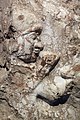
Relief block detail

Relief block, copy, original in the Sivas Museum

Finds from Kayalıpınar in the museum


Ancient name
The following considerations bring Müller-Karpe to the identification of Kayalıpınar with Šamuḫa (2000: 363): The text of the Ištar festival ritual itself does not provide any reference. However, the importance of the site in Kayalıpınar (location important in terms of traffic, size of the city of 20 hectares, rituals held in the presence of the great king) suggests that it was registered in the Boğazköy archives. Of these, only Ḫurma and Šamuḫa come into question because of their close geographical relationship to Šarišša . Of these, only Šamuḫa, together with Pitiyarika and Arziya (both of which were less large and important), lay on a navigable river, which in the vicinity of Šarišša can only be the Kızılırmak, next to the upper Euphrates the only navigable river in Inner Anatolia. In addition, Šamuḫa's most important deity was the Ištar, just like Kayalıpınar's “Divine Mistress” ( d GAŠAN) was an Ištar figure according to a clay tablet. According to studies by van Gessel (1998: 35), d GAŠAN must also be read as Šaušga, which corresponds to the Hurrian form of Ištar. And the cult in Samuḫa in particular was generally Hurrian. So Müller-Karpe (ibid.) Comes to the conclusion: "The majority of the evidence therefore speaks in favor of the localization of Šamuḫa at this place."
literature
- Andreas Müller-Karpe: Kayalıpınar in Eastern Cappadocia. A new Hittite clay tablet find place. In: Mitteilungen der deutschen Orientgesellschaft 132, 2000, pp. 355–365.
- Andreas Müller-Karpe: Investigations in Kayalıpınar 2005 . In: Mitteilungen der Deutschen Orient-Gesellschaft 138, 2006, pp. 41–77.
- Andreas Müller-Karpe, Vuslat Müller-Karpe: Investigations in Kayalıpınar 2006-2009. In: Mitteilungen der deutschen Orientgesellschaft 141, 2010, pp. 173–238.