
Ḫattuša
| Ḫattuša: Hittite capital | |
|---|---|
|
UNESCO world heritage |
|
.jpg)
|
|
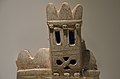
| Reconstructed section of the auerattuša city wall ( see below ) |
|
| Contracting State (s): |
|
| Type: | Culture |
| Criteria : | (i) (ii) (iii) (iv) |
| Area: | 268.46 ha |
| Reference No .: | 377 |
| UNESCO region : | Europe and North America |
| History of enrollment | |
| Enrollment: | 1986 (session 10) |
Coordinates: 40 ° 1 ′ 16 ″ N , 34 ° 36 ′ 53 ″ E

Ḫattuša or Hattuscha (also Hattusa , Turkish Hattuşaş ) was the capital of the Hittite Empire. Their remains are in the Turkish province of Çorum near Boğazkale (formerly Boğazköy) in the Anatolian highlands, about 180 kilometers east of Ankara . North of the ancient landscape Cappadocia was there in the arch of the Kızılırmak (ancient Halysbogen) in the 2nd millennium BC The core of the Hittite empire, in the center of which was Ḫattuša. The place was from the late 3rd millennium BC. Inhabited until the 4th century AD and again in Byzantine times in the 11th century AD. From the late 17th to the beginning of the 12th century BC. The place was the capital of the Hittite empire.
Ḫattuša is located at the transition from the Budaközü plain to the steep mountains in the south. With an area of around 180 hectares, it is one of the largest ancient city complexes in the world. The population is estimated at between 10,000 and 12,000. Over a north-south length of 2.1 kilometers, the terrain rises by around 280 meters. The area on the slope is broken through by numerous rocks that were built up throughout the Hittite period. During the time as the capital, Ḫattuša was enclosed by a 6.6 kilometer long city wall and could be entered via five well-known gates from the outside, and another three gates could be excavated in the section walls within the city. In addition to numerous other finds, more than 30,000 clay tablets, mostly preserved in fragments, came to light, which were written with cuneiform texts in Hittite, Old Assyrian and several other languages. The texts provided valuable information about the great Hittite empire. The excavated architecture is mainly public buildings, including the royal palace on the Büyükkale plateau . Remains of over 30 temples were found all over the city. In the absence of written evidence, it is not clear to which deities they can be assigned. So far, only a small part of the residential areas in the lower town has been exposed. The vast majority of the site is still awaiting excavation.
The Boğazköy area has been archaeologically researched since the end of the 19th century, initially between 1906 and 1912 under the direction of the Istanbul Archaeological Museum and with a significant contribution from the German Orient Society and the DAI (1907) under the auspices of the German Archaeological Institute Istanbul . In 1986, Ḫattuša and the neighboring Hittite sanctuary Yazılıkaya were entered on the UNESCO World Heritage List. Both places and the wider area belong to the Turkish National Park Boğazköy-Alacahöyük . In 2001 the cuneiform tablet archives found in Ḫattuša were included in the UNESCO World Document Heritage .
topography
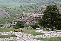
The site of Boğazköy with the ruins of the Hittite capital is located in northern central Anatolia. It lies in the center of the Hittite heartland in the so-called Halysbogen, the arch that the ancient river Halys (Hittite Marassanta , today Turkish Kızılırmak ) describes on its way to the Black Sea . The northern part of the urban area is relatively flat, while the southern part stretches up a steep slope. With a north-south extension of around 2.1 kilometers, the terrain overcomes a height difference of around 280 meters. Two brooks arise in the southern mountains and join in the area of the modern village of Boğazkale to form Budaközü. This crosses the northern plain, flows further into the Delice Çayı , which finally flows into the Kızılırmak. The main part of the urban area of Ḫattuša lies on the spur of the terrain between the two streams. The eastern of the two source brooks cuts in the northeast the urban area between Büyükkaya in the northeast and Ambarlıkaya in the southwest. To the north of it still lay parts of the lower town. The two streams form deep gorges, the eastern of which is called Büyükkaya Deresi and the western, which runs outside the city area, Yazır Deresi . The southern steep slope is characterized by numerous limestone breakthroughs, including Kesikkaya, Kızlarkayası, Yenicekale and Sarıkale in the west, the Yerkapı wall in the south and Büyükkale, Ambarlıkaya and Mihraplıkaya in the east. The rocks were included in the urban planning, on most of them there are buildings from Hittite and later times. The fact that the elevations were easy to defend and that the terrain was also strategically located due to the mountains in the south and the plain in the north, which was easy to see, was certainly one of the reasons why the first rulers chose the location. Another advantage were numerous springs on the mountain slope, which, together with cisterns and later artificially created ponds, ensured the drinking water supply for the population.
Due to its location between the mountain ranges of the Pontos Mountains in the north and the Taurus in the south, Central Anatolia has a continental climate with hot summers and cold winters. Since the annual rainfall is quite low at 550–600 milliliters, the country only allows one harvest per year. The possibilities of artificial irrigation are very limited. The environmental conditions at the time of the Hittites are difficult to reconstruct, but at least pollen analyzes indicate that the climatic conditions have hardly changed in the past 12,000 years since the end of the last ice age. However, during the time of settlement by the Hittites, the forest population fell sharply. This is certainly due to the intensive use of wood for pottery and metal processing, but also as a building material. Remarkably, after the site was abandoned by humans, nature has reclaimed large parts of the site. Old photographs show that large parts of the upper town were overgrown with dense forest until the 20th century, which is why the temple district at that time had the Turkish name Ağaç Denizi (forest-sea). In the early 1980s, the excavation manager at the time, Peter Neve, had a piece of forest fenced in south of Yerkapı so that it was protected from being bitten by herds of goats in order to give the visitor an impression of the former landscape. The forest can be seen clearly from the Sphinx Gate.
Agriculture and Food
The supply of the Hittites was based on agriculture and animal husbandry. Because of the unfavorable soil conditions, the collection of wild fruits was used as a supplement. The greatest contribution to the nutrition of the population was made by the cultivation of cereals, mainly barley, emmer and wheat being used. In the ancient Orient no distinction was made between the types of grain, but barley had the largest share here, as it is more resilient and frugal, i.e. it also produces yields on less good soils. Since the soils around Ḫattuša were not very productive, every available piece of earth had to be used for cultivation; spelled and millet were also used. Legumes such as lentils, peas, chickpeas and various types of beans were also grown, as were vegetables, including carrots, cucumbers, onions and garlic, and spices (cumin, thyme, mint, parsley, coriander and cress). Furthermore, types of fruit were also grown or collected, such as apples, "mountain apples" (apricots?), Olives, wine, nuts and berries. All fruits mentioned have been archaeobotanically proven, in texts still others are mentioned, the names of which, however, cannot yet be interpreted. Part of the grain was processed into bulgur to preserve it , a method that has been demonstrable in the Near East since the Neolithic. Most of it was baked into bread, which was available in numerous varieties. Breads with cheese, fruit, herbs, meat fillings and many more, also with honey glazes, are known through texts. Another way of using grain was brewing beer. However, this had little resemblance to today's beer, was thicker and had a lower alcohol content. Another use of the grain was as a concentrate for horses. As an emergency supply for times with poor harvests, there were large grain silos in the city, one by the postern wall and large pits up to 12 × 18 meters in size and two meters deep on Büyükkaya. The largest of these alone had a capacity of at least 260 tons of grain. They were sealed watertight, airtight and protected from pests, so that the contents remained edible for several years. This storage method is still common today in third world countries, but also in parts of Turkey. In contrast to private stores, the contents of these stores were often heavily contaminated by weeds, which is probably due to the fact that these were compulsory levies on the state.
Cattle breeding served as the second basis of the food supply. The majority of these were cattle, sheep and goats, and to a lesser extent pigs. Sheep and goats were in the majority, but the cattle formed the most important part, as they were far more productive in terms of meat yield. Investigations of the bones found showed that the slaughter date was relatively late in all animals, in sheep and goats in the second year of life, in cows even later. This indicates that the animals were not only kept for consumption, but also for the production of milk and wool. Another factor in cattle was their use in field work. The animals were kept in herds that grazed outside the city during the day. From an instruction for the hazannu , the city commandant, it emerges that most of the herds were driven back into the city towards evening and were probably housed in stables belonging to the residential buildings. Poultry remains were found in small numbers (geese, ducks) and occasionally fish. Horses, donkeys, mules and mules were kept not for consumption but as transport animals. Horses were used on the one hand as riding animals, on the other hand as draft animals for the fast chariots. Beekeeping for honey production is also documented by cuneiform texts. The hunt was more for the ruler's pleasure and had only a subordinate function for food.
The excavator Andreas Schachner estimates the population of the capital at around 10,000 to 12,000 people based on the size of the available cultivation area and the agricultural possibilities at the time .
Research history


In 1834, the French explorer Charles Texier visited the Central Anatolian highlands and discovered the ruins of the city. However, he thought they were remnants of the Median city of Pteria . Texier documented and sketched the obvious ruins of the city area as well as the nearby rock sanctuary Yazılıkaya . After Texier, other explorers visited the city in the following decades, including in 1836 the Englishman William John Hamilton , who made drawings of the Great Temple. He identified the site as the Galatian tavium . In 1858 Heinrich Barth and Andreas D. Mordtmann visited the ruins, they uncovered the smaller chamber B of Yazılıkaya. In 1861 the archaeologist Georges Perrot visited the place with Edmont Guillaume and Jules Delbet, where the architect Guillaume made more detailed drawings of the reliefs of Yazılıkaya and the doctor Delbet made the first photographs of Yazılıkaya, Yenicekale and Nişantaş. Carl Humann created a topographical plan in 1882 and had plaster casts of numerous reliefs made in Yazılıkaya, which are now exhibited in Berlin in the Vorderasiatisches Museum .
The first excavations took place in 1893/94 when the French Ernest Chantre dug probes in the Great Temple, on Büyükkale and in Yazılıkaya. He also discovered the first cuneiform tablets. The systematic archaeological research began in 1906. Hugo Winckler , a Berlin Assyriologist and cuneiform researcher, and the Istanbul Greek Theodor Makridi , a curator of the Istanbul Archaeological Museum, carried out the first excavation campaign on behalf of the Ottoman Museum in Istanbul , carried out by the German Orient Society was financed. They were able to recover 2500 fragments of cuneiform tablets and, based on the texts in Akkadian, prove that they had found Ḫattuša, the capital of the Hittite empire. In 1907 Winckler and Makridi continued the excavations. This year the German Archaeological Institute (DAI) was also involved for the first time under the direction of Otto Puchstein . The ruins have been fully documented with numerous plans, photographs and a more detailed topographical map. In 1911/12 Winckler and Makridi carried out further excavations. Until 1912 excavations were carried out in the lower town (Great Temple), on the royal castle and in the upper town (Löwentor, Königstor, Sphingentor). Until then were ten thousand fragments of cuneiform - clay tablets recovered. Among the finds was a version of the Akkadian peace treaty between Egypt and Ḫatti , which was concluded between Ḫattušili III. and Ramses II had been concluded - the earliest surviving equal peace treaty in world history. Using the tablets, Bedřich Hrozný succeeded in developing the Hittite language in 1914/15 .
After the First World War, the excavations were inactive for more than a decade and were not resumed until 1931 by the German Archaeological Institute under the direction of Kurt Bittel . Due to the Second World War, work was suspended again from 1939. In 1952, Bittel was able to continue exploring the city. The focus of his work was the uncovering of the royal castle, extensive investigations in the lower town and excavations in the area around Ḫattuša (Yazılıkaya and Yarıkkaya). Until 1975, the excavation work was carried out jointly by the German Archaeological Institute and the German Orient Society. Bittel's successor was Peter Neve in 1978 , under whose direction extensive excavations and restorations were carried out in the area of the central and eastern upper town. In 1994 Jürgen Seeher became head of the excavations. In 2006 Andreas Schachner took over the excavation management.
The German Archaeological Institute, Istanbul Department, has been digging continuously in the city since 1952, bringing new findings to light every year. Between 2003 and 2005, under the direction of Jürgen Seeher, a section of the city wall was reconstructed using old techniques and materials. Areas outside the city have also been investigated recently, including the Chalcolithic settlement in Çamlibel Tarlası.
The long-term research project Ḫattuša was awarded the Shanghai Archeology Award in the category " Research " in 2019 .
history
Pre-Hittite period


With the warming that followed the end of the last Ice Age, living conditions gradually improved in Anatolia from southeast to northwest, as a result of which people also roamed northern central Anatolia. Occasional incidental finds of stone tools in the wider area of Boğazköy show their presence in this area as well. The emergence of settlements by arable farmers and cattle breeders continued in the 9th and 8th millennium BC. However, further south ( Çatalhöyük ), the first producing cultures of the Neolithic period on the Anatolian plateau emerged in the 7th and 6th millennium BC. Further south ( Hacılar , Kuruçay , Höyücek ). The prehistoric people were technically not yet able to master the vast forest areas of northern central Anatolia. The first settlements in the area around Boğazköy emerged in the 6th millennium BC. BC in the Chalcolithic period perhaps on the Büyükkaya ridge in the urban area of Ḫattuša and secured in the 5th and 4th millennium BC in Büyük Güllücek, Yarıkkaya and Çamlıbel Tarlası in the vicinity of Boğazköy. The settlers may not have come from the south but from the Black Sea , which elements of material culture might suggest. All of the settlements were not formed by Höyüks , which were inhabited for a long period of time, as in the southern region , but were at a medium altitude and consisted of a few rectangular one-room houses. They were only used for a relatively short time until the land resources were depleted. For the period from the late 4th to a demonstrable settlement of the area in the late 3rd millennium BC. There are no archaeological traces in the immediate vicinity of Boǧazköy. Then, at the end of the Early Bronze Age , the area between Büyükkale and the northwestern area of the lower town, known as the northwest slope, and on Büyükkaya began to be densely populated, which was already urban in character. The settlement included multi-room houses in which traces of manual activities such as metalworking and pottery were found. It is assigned to the population group of the Hattier , who from the 3rd millennium BC onwards. Appeared between the Black Sea and the arch of Kızılırmak . During this time, the name Hatti for the kingdom of a king Pamba in northern Anatolia appears for the first time in a text from Mesopotamia .

At the beginning of the 2nd millennium BC Chr. Began Assyrian merchants to establish a network of trading posts, Karum ( Assyrian for port , transfer port of the caravans) called that stretched from Central Anatolia in the west to Iran in the west to the east. They traveled with donkey caravans from Aššur on the Middle Tigris to Asia Minor in order to exchange mineral resources there such as copper, silver and gold for tin and materials from Mesopotamia. The center of their trade routes was Kanis, today's Kültepe near Kayseri in the south of Boǧazköy. The stations were each on the edge of the Anatolian cities in their own districts. Such a base also arose immediately to the north-west of the town, which at that time was concentrated on Büyükkale and the north-western slope. At that time Büyükkale already had a prince's seat, the Hattic settlement was on the northwest slope, while the Karum was northwest of it, in the area of the later lower town or the Great Temple. With the Assyrians, writing came to Central Anatolia for the first time in the form of Assyrian cuneiform . In Kültepe in particular, but also in Boǧazköy, numerous clay tablets with texts in the Assyrian language were found. Since these are mainly letters and economic texts from the merchants, they provide information about everyday life in an Anatolian city at that time. We also know the name of the city Hattusch (Ḫattuš). The profit-oriented trade of the merchants contributed significantly to the prosperity and growth of the cities and their princes and thus to the acceleration of urbanization. The houses became more spacious, showing a greater separation of living and working areas. The area of the city, which also included scattered parts of the later upper town, was at least 48 hectares and thus corresponded to that of other contemporary centers such as Kültepe and Acemhöyük .
Already at the end of the 3rd millennium BC In Mesopotamian texts about Anatolia, personal names interpreted as Indo-European were found for the first time , the origin of which has not yet been clarified. Some of the research suggests it is northeast of the Black Sea. In an attempt to expand their power, disputes arose between the Central Anatolian rulers. Archaeological traces in the urban area show that around 1700 BC The city was destroyed in a fire. In a later, Hittite cuneiform text , King Anitta von Kaniš , who came from Kuššara , reports :
“ I took the city by force during the night, but planted weeds in its place. Whoever becomes king after me and settles Hattusch again, the weather god of heaven shall meet. "
According to the prevailing opinion for a long time, the place was not inhabited for about a hundred years. Due to more recent finds in the lower town, however, it now seems likely that there was still a settlement in Hattusch directly after Anitta.
Hittite period


Around the middle of the 17th century BC A Hittite ruler named (or the title) Labarna took Ḫattuša as the first great king as the capital of his empire, according to legend, despite Anitta's curse. He also came from the town of Kuššara, which has not yet been localized, but which, according to various text finds, is believed to be southeast of the capital. After his new residence town, which was now called Ḫattuša, he took the name Ḫattušili , that of Ḫattuša . The excavator Andreas Schachner assumes that he did not choose the location at the time to create the center of a large empire here, but rather because of the strategically favorable landscape conditions. This made the city a safe haven against the internal Anatolian fighting of that time. It is believed that he had already fortified the settlement, although his successor Ḫantili (early 16th century BC) claimed that he was the first to wall the city. It is probably the so-called postern wall, which later marked the border between the lower and upper town, and the northern perimeter wall, which is now partially hidden under the modern town. The exact construction date of the individual wall sections cannot be determined. The fortification was initially directed against the Kaškäer , a group of tribes who lived in the Black Sea area and who oppressed the Hittites from there throughout their reign. Even if the earliest written records about the Kaškäer from the 14th century BC It is believed that they date back to before the 16th century BC. Lived there, possibly even anatolian natives. At that time, the development of the city was concentrated around the two core areas of Büyükkale and the lower town. The fortified ruler's seat was already on Büyükkale, the lower town took up roughly the area of the large temple and its surroundings, but the north-western slope between the seat of government and the lower town was also built on according to archaeological evidence, where the remains of a large, underground grain silo were found right next to the postern wall. Together with the Büyükkaya ridge, the built-up area took up an area of around 0.9 × 1.2 kilometers.
In the centuries that followed, the lower town was further expanded, the remaining residential buildings on Büyükkale disappeared and were replaced by public or representative buildings. The large temple with its surrounding magazines and the house of labor in the lower town was probably built as early as the Old Ethite period. The houses became larger and more regular, they appear from the 16th century BC. Chr. To have served not only economic, but also representative purposes. A text from the time of Tudḫaliya III. around 1400 BC Chr. Reports again of a fire in the city, probably by the Kaškäer.
In the past it was assumed that the expansion of the upper town only took place in the late period of the great empire. Today, numerous finds show that this planned conversion was carried out as early as the 16th century BC. Began. At an elevated point, to the northeast of what will later become the Löwentor, grain stores and then water reservoirs, the so-called southern ponds, were created. Civil development has been proven to the west of Sarıkale, a rock in the southwest of the urban area; in contrast to the old town, it is very straightforward and regular. And over the period from the 16th to the 14th century BC A temple district with 27 cult buildings was built on a slope between Sarıkale and Büyükkale. When the fortifications of the upper town were built cannot be precisely established, but it is unlikely that the fortification was built in the 16th century BC. The southern ponds begun in BC, the residential buildings and the first temples were not fenced. Contrary to the earlier assumption that the construction of the five monumental gates of the city wall and the representative expansion of Yerkapı, the southern part of the city wall, only took place in the last phase in the 13th century BC. Andreas Schachner dates both to the 16th or 15th century BC. Chr.
In the early 13th century BC In BC Muwattalli II moved the capital of the empire from Ḫattuša to Tarḫuntašša , a city in the region of the same name in southern Anatolia, the exact location of which is still unknown. The reason for the relocation is unclear, but he relocated it with the gods of Hatti and the Manen (the spirits of the ancestors), which naturally represented a profound turning point in the city's history. Even if after a few decades his successor Muršili III. returned to the old capital, during this time the upper town changed from a cult to an artisan quarter. Most of the temples in the upper town's temple district were abandoned and overbuilt by pottery workshops. Muršili was by his uncle Ḫattušili III. discontinued. Under him and his son and successor Tudḫaliya IV , the city experienced its last heyday. Above all, the palace complex on Büyükkale was monumentally expanded with courtyards surrounded by columned halls, an audience hall and the actual royal palace. Tudḫaliya was also responsible for the splendid relief decoration of the rock sanctuary of Yazılıkaya outside the city. The latter's son and last king of the Hittite Empire, Šuppiluliuma II. Was the builder of the large inscription from Nişantaş and, east of it, in the area of the southern castle , a cult complex made up of the two eastern ponds, two chambers and a temple. One of these chambers, which is equipped with reliefs and a large inscription, is called DINGIR.KASKAL.KUR, which means, for example, an entrance to the underworld.
Traces of a Hittite settlement have also been found outside the fortified city. For example, between Büyükkaya and Yazılıkaya there is evidence of loose development, and the Osmankayası rock group located there, the only necropolis in the vicinity of the city has been excavated to date. It was from the 17th to the 14th century BC. In use. Remains of an upstream defense structure were found southeast of the city in the Kayalıboğaz Gorge. In the east beyond the road leading to Yozgat , west of Yazılıkaya, two water reservoirs have been identified, which probably belonged to an irrigation system for the fields.
Why in the early 12th century BC The Hittite empire disintegrated and the capital was abandoned is still unclear. Internal disputes are possible causes - possibly as a late consequence of the usurpation of the throne by Ḫattušili III. - in question, as well as famines, either due to climate change or as a result of over-exploitation of resources. Also the sea peoples storm , which at the time beset the neighbors of the eastern Mediterranean, possibly had at least indirect effects as far as central Anatolia, as long-distance trade relations broke away. Traces of fire were found on numerous buildings in the city, but since most of the rooms had been cleared beforehand, an attack is not likely. It is also not possible to tell whether the fires took place at the same time or at intervals. The general research opinion today tends to have a mixture of all of these possible causes.
Jürgen Seeher thinks it is possible that Šuppiluliuma II left the city as planned and moved the capital again. The Australian historian Trevor R. Bryce agrees with him. Zsolt Simon suspects that a great king Tudḫaliya V, perhaps his son, succeeded him there and that the empire continued to exist - albeit now meaninglessly.
Post-Hittite period

Contrary to the earlier view that the end of the capital was followed by a pause of settlement of several centuries, excavations on Büyükkaya show that a smaller settlement existed there, whose inhabitants may also include remnants of the Hittite population. However, the findings also show that these people fell back to a cultural level that partly corresponded to the Stone Age. The residents lived in small pit houses, the use of the potter's wheel for ceramics was soon forgotten, as was the use of writing. It is possible that the settlers were groups from northern Anatolia who took advantage of the power vacuum that had developed. The settlement on Büyükkaya expanded over the centuries over the entire surface of the hill, and smaller settlements emerged in the rest of the city, for example at the house on the slope , at Temple 7 in the upper town and on Büyükkale.
In the first half of the 8th century BC A fortification was built on Büyükkale again. On the basis of finds such as a Cybele statue and inscriptions in Phrygian on ceramic shards, it is generally associated with the Phrygians living in western Central Anatolia , whereby the findings of material culture speak for an independent sociopolitical structure. In the 7th / 6th Century BC The south castle was built - probably at least for a time in parallel - south of Büyükkale, in the area northwest of the eastern ponds and the Hittite cult grottos, in the western area of which a residential area was built. Both Büyükkale and the south castle were surrounded by strong walls. The spread of the Medes in the early 6th century BC BC and later the Persian Achaemenids to Anatolia had no archaeologically visible influence on the material culture of the city. Life continued until the city in the 5th century BC. Chr. Lost in importance. It is unclear whether the settlement was actually completely abandoned.
Another cultural upheaval in the region brought in the 3rd century BC. The Galatians , the eastern Celts , who advanced from south- eastern Europe via western Anatolia to central Anatolia. The Trokmer tribe had its center in Tavium near today's Büyüknefes, about 20 kilometers south of Boğazköy, from where they also took possession of the area of Ḫattuša. Evidence of this is given by traces of residential development on the northwest slope , a small fortress near Kesikkaya and isolated stone box graves and pithos burials in the lower town.
After about 25 BC The Roman Empire took control of the Trokmer area and made it the province of Galatia . Only a few scattered village settlements in the vicinity of the city bear witness to this time. In the 1st century AD the Romans built a road from the provincial capital Tavium to the north, probably to Amasia , which passed a few kilometers east and north of the Boğazköy area. In the ruins of the Bronze Age and Iron Age city of Boğazköy, a Roman military camp was first built, which was built over with a spacious villa complex in the first half of the 1st century AD. In the vicinity of the Great Temple and in the lower town, an extensive necropolis was uncovered from this period, while the remains of a small, probably late imperial fortification were found on Büyükkale. Numerous cuts on rocks and ashlar in the Great Temple also show that the Romans used them as a quarry. The traces can be seen most clearly on the rock of Kessikkaya in the west of the city.

Only sparse evidence from the early Byzantine period has survived, but in the upper town, on the northern edge of the temple district, remains of a central Byzantine settlement with a monastery and several churches from the 10th to 11th centuries have been excavated and partially restored. Spolia from the 6th to 8th centuries were built into it, suggesting an earlier small settlement. The existing Hittite complex on Sarıkale was rebuilt and fortified during this period. Remains of Byzantine buildings have also been found on the Yenicekale boulder to the south. The datable coin finds end around the 1060s, so that it can be assumed that the settlement was abandoned at that time, probably in the course of the immigration of Turkish tribes from the east.
In the following centuries there was no evidence of settlement activity in the Boǧazköy area. From the time of the Seljuk principalities from the 12th century onwards, there are only a few coin finds, which can be traced back to nomads passing through. In the 15./16. In the 19th century, the Seljuk beylik of the Dulkadiro ğulları was smashed by the Ottomans . As a result, a scattered branch of the family, originally from the area of Maraş , first settled in Yekbas (temporarily Evren), and finally founded Bo imazköy, today's Boğazkale, three kilometers further south in the 17th century. The relocation of the settlement from the level of the Budaközü brook into the mountainous and therefore more protected landscape was probably due to the turmoil caused by the so-called Celali uprisings . The Konak, the grand residence of the family, still exists today. It was members of this clan, Ziya Bey and Arslan Bey, who at the end of the 19th and beginning of the 20th centuries provided accommodation and support for Western researchers and archaeologists with their excavations.
The city

City walls
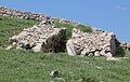
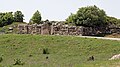
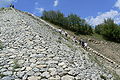
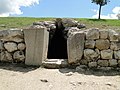
The Hittite urban area was surrounded by a wall all around and crossed by further section walls. The outer walls had a circumference of 6.6 kilometers, with all sections within the urban area, the walls are more than nine kilometers long. The oldest Hittite wall is the postern wall, which, according to his own statements, was built under Great King Ḫantili I in the late 17th or early 16th century BC. Was built. However, it cannot be ruled out that there was already an older predecessor. The postern wall initially only covered the area of the old town, now also known as the lower town. It ran in the southwest from Kesikkaya in the west to Büyükkale in the east, went around this fortress in the south and east and continued to the north, crossing the deep gorge of the Budaközü between the elevations Ambarlıkaya and Büyükkaya. In the gorge she skipped, it is suspected that the course of the stream might have been cordoned off by a kind of grid. From there it continued over the height of Büyükkaya and circled the city in a large arc, finally closing the ring at Kesikkaya. The northern sections are largely overbuilt by the modern site or lie under fields and have not yet been excavated. The foundation walls are visible in the urban area, which were restored over a distance of several hundred meters east of Kesikkaya. The wall is named after the tunnels that run under the wall at intervals of between 70 and 180 meters. Eight posterns have been identified on the section between Kesikkaya and Büyükkale. Like the similar building near Yerkapı, they are built as a cantilever vault . However, the posterns of the old town wall, which are buried today, are much smaller than Yerkapı and are concealed. One possible function is that of sideline gates to fight the attacker outside the city. The actual purpose is ultimately unclear. In the course of the restoration, some of the entrances were exposed. The fortification was built using the so-called box construction - an Anatolian invention, probably a reaction to the development of battering rams. Two walls were built in parallel, between which cross connections were drawn. By filling the boxes with earth, stones and broken clay bricks, a wider and therefore more resistant wall was created. The walls stood on ramparts, some of which were artificially raised. The foundation was a base made of quarry stone dry masonry, the actual wall consisted of plastered, air-dried mud bricks . Towers protruding from the wall were integrated at irregular intervals, a total of over a hundred. The height of the walls can only be guessed at. The stone plinth was perhaps 3–4 meters high, on top of which rose the structure made of timber framework and mud bricks, of about the same height, which was crowned by a battlement with battlements. The towers were certainly a lot higher. Numerous well-known clay models, on which the arched shape of the battlements can be recognized, and the replica of a section of the wall in the lower town based on these models give an idea of the appearance of the wall.
When the wall was built around the upper town to the south cannot be determined with certainty. But since as early as the late 16th century BC When parts of the upper town were intensively built on and used, it can be assumed with great probability that the upper town was already fortified at that time. The wall connected to the postern wall to the west of Kesikkaya and met the old fortification again on the southeast corner of Büyükkale. It was also built as a box wall, although the postern was now dispensed with. Around the 15th or 14th century BC. A section wall was drawn in in the lower town, which branched off from the northern city wall, passed the large temple to the northwest and met the postern wall to the west of Kesikkaya, where the south city wall also joined. Probably in the 15th, possibly not until the 14th century BC. BC, the external threats no longer seem to have been so strong that the walls were no longer so much used for defense as they were dedicated to representative purposes. This can also be seen in the large windows of the towers, which, although not archaeologically verifiable, are known from the clay models. The monumental expansion of the ramp of Yerkapı on the southernmost section of the wall may also take place during this period. It wasn't until the late 13th century BC. The threat to the city, possibly from internal political disputes, became so significant again that a second city wall was placed in front of the southern wall. Probably also during this time another section wall was built on Büyükkaya, which branched off to the west north of the granaries and connected to the western section wall at Mihraplıkaya. This protected the storage facilities against unauthorized access; they could only be entered through a guarded gate.
Clay model of a city wall in the Museum of Anatolian Civilizations , Ankara
Restored postern near Kesikkaya
City walls on Büyükkaya, clearly visible the box construction with protruding towers and the branching wall section

City wall at the Sphinx Gate (left) and additional wall in front of it (right)
.jpg)


Partial reconstruction of the city fortifications

Between 2003 and 2005, a 65 meter long section of the fortification walls was rebuilt by the DAI: three 7 to 8 meter high wall sections and two 12 to 13 meter high defense towers. The Japanese group JT International supported the project as a sponsor.
The archaeologists worked in the sense of experimental archeology with historical materials and historical processes. They produced 64,000 mud bricks, for which they processed 2,700 tons of clay, 100 tons of straw and around 1,500 tons of water. In addition, around 1,750 tons of debris were required for backfilling and the construction of ramps, as well as logs for the construction of the tower floors. The usual dimensions of the square mud bricks (about 45 × 45 × 10 centimeters, around 34 kilograms) were known, as some bricks had been preserved intact. Clay models of the city wall, which the Hittites attached to the rim of large cult vases, served as a reference point for the design.
An average of 27 workers were at work for about 11 months. The workload added up to 6772 man-days, although excavators, tractors and trucks were used to procure the material in order to be able to keep costs under control. How much the corresponding effort was in the times of the Hittites, who worked without the support of machines, could only be estimated. Projections showed that the Hittites had to employ around a thousand workers if they wanted to build one kilometer of city walls a year. The archaeologist responsible for the project, Jürgen Seeher , assumes that it was mainly prisoners who built the old city walls. In several cuneiform texts it is reported that the kings of the Hittites brought thousands of people with them as booty from their campaigns to compensate for the chronic shortage of labor.
When calculating the historical labor demand, longer breaks during the winter months were factored in. Mud brick production in Central Anatolia is only possible in summer when it is warm enough and does not rain, around mid-June to mid-September. The experimental project also includes continuous observation of the structure with regard to how the weather affects the building fabric and how often the plaster that protects the clay bricks but is washed away by rainfall over time needs to be touched up.
City gates

The postern wall between Kesikkaya and Büyükkale, which separates the upper and lower town, had at least two gates, one at the foot of Büyükkale and another, only excavated in 2009, west of Kesikkaya. The western section wall had at least two passages, one north of the great temple, where the modern road leads to the excavation site today, and one west of the temple. They were probably built together with the temple and wall in the 15th or 14th century BC. Built in BC. Whether and where there were further gates in the section wall cannot be determined archaeologically. The same applies to the gates of the northern perimeter wall of the lower town.
The southern city wall around the upper town had five monumental gates, of which the Sphinx Gate occupies a special position. The other four had a parabolic-shaped passage on the outside and inside, which was closed with wooden gate leaves. The stone pans in which the door hinges turned and the traces of grinding on the wings can still be clearly seen, especially at the Königstor. Both passages could be closed with bolts from the inside, i.e. from the city side. The recesses into which the bolts were pushed can still be seen in the side walls of the Löwen- and Königstor. In a text about the duties of the hazannu (for example city commander) it is stipulated that the gates had to be locked and sealed every evening and that the seals had to be checked for integrity every morning. With the exception of the Sphinx Gate, the gates are each flanked by two towers. Two of the gates are in the western section of the wall, the Lower West Gate in the northwest of Kızlarkayası, through which a footpath that is still usable today leads up from Boğazkale, and the Upper West Gate to the west of Kızlarkayası. In contrast to the other gates of the upper town, they were not decorated with relief decorations. The three other gates are all in the southern part of the fortification, they are the lion gate in the southwest, the sphinx gate at the southernmost point and the king gate in the southeast.
Lion gate
As with all large gates, the gate chamber of the Löwentor is flanked by two towers with rectangular ground plans of around 10 × 15 meters. The carefully crafted polygonal masonry can be clearly seen on the outer façade of the western tower, which is still 4.6 meters high . The external processing of the stone blocks on this gate has not been completed, the reason for this is controversial. Outside, a ramp leads diagonally from the east to the gate, which was accompanied by another wall with a tower. The two passages were formed by mighty stone blocks that together formed a parabola. From these blocks, two lion figures are carved out on the outside of the gate, after which the gate takes its modern name. Lions were very common gatekeepers in the Hittite Empire as in the entire ancient Orient. Such gate figures may also have stood at various gates in the Büyükkale royal castle. The figures are very carefully worked, which can be seen, for example, in the fine structure of the mane, the paws and the depiction of the faces with threateningly open mouths, tongues hanging out and eyes wide open. The eyes were probably originally formed from a separate mass of limestone with black pupils and inserted into drilled holes. To the left of the head of the western lion are weakly carved hieroglyphs . They cannot be fully interpreted, the sign for “gate” ![]() PORTA is legible at the end , possibly the Hittite name of the gate was mentioned here. In 2010 and 2011, the gate was extensively restored, cracks in the door frames and damage to the right lion removed and the head of the left lion, which was lost in antiquity, was reconstructed.
PORTA is legible at the end , possibly the Hittite name of the gate was mentioned here. In 2010 and 2011, the gate was extensively restored, cracks in the door frames and damage to the right lion removed and the head of the left lion, which was lost in antiquity, was reconstructed.
Löwentor city side

Gate Chamber

Lion sculptures outside

right gate lion

Inscription on the left lion


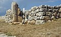
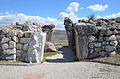
Sphinx Gate
The Sphinx Gate (occasionally also Sphingentor) stands at the highest and southernmost point of the city wall. In contrast to the other four gates, it is not flanked by towers, but the passage leads through a tower. The door reveals here also do not have a parabolic shape, but are rectangular with a lintel. In addition, only the outer passage was provided with door leaves and lockable, the city-side gate side remained open. The Sphinx Gate was a pedestrian gate that could be reached from the outside of the city via the stairs on the sides of the mighty ramparts of Yerkapı. One suspects a cultic significance for the wall as well as for the gate, but the function cannot be proven by any text passages. The Sphinx Gate takes its current name from the four sphinx figures that guarded the entrance and exit. On the outside only remains of the left, western sphinx are preserved, only feet with paws and traces of the headdress are still recognizable. On the right side the block with the Sphinx is lost. The rest of the soffit block shows chisel marks indicating that the block was used as a building material. The two sphinxes on the inside were excavated in 1907 (see below). In 2011, after a restoration, two copies were placed at the inner gate, the reassembled originals are in the Museum of Boğazkale. Most of the original parts that have been preserved have been reused by the Eastern Sphinx. The Hittites probably adopted the shape of the Sphinx from northern Syria from the Egyptian culture , but the Hittite Sphinx, in contrast to the Egyptian, is female, which can be recognized by the facial features and body shape. The beings are almost fully sculpted at the front and in high relief on the sides. Large wings rise above the body, the tail is curled up over the rump. The face has feminine features with inlaid eyes, two braids fall on the right and left side of the chest. In these braids ending in curls, the figure's origin from Egypt is evident, it is comparable to the hairstyle of the sky goddess Hathor . The head is adorned with a helmet with cheek flaps and horns as a sign of divinity. Six rosettes can be seen above the helmet, the meaning of which is unclear. Five hieroglyphs can be seen on the base of the wing of the western sphinx. The Turkish Hittitologist Metin Alparslan recognizes the two characters ![]() REX for king and
REX for king and ![]() SCRIBA for scribe . He concludes with reservation that a king who knows how to write (not a great king) is responsible for the graffito . From the remaining characters he reads the name Ni (a) -ZITI, which, however, does not appear anywhere in known texts.
SCRIBA for scribe . He concludes with reservation that a king who knows how to write (not a great king) is responsible for the graffito . From the remaining characters he reads the name Ni (a) -ZITI, which, however, does not appear anywhere in known texts.

Sphinx Gate city side

western sphinx

Inscription on the wing of the western sphinx

Obituaries
Exterior front


Reclaiming the "Sphinx of Ḫattuša"


In 2011 the efforts of the Turkish government, which had been going on for decades, to bring back the so-called "Sphinx of Ḫattuša" from the Museum of Near Eastern Art in Berlin reached a new high point. It is one of the two Sphinx figures that Otto Puchstein found in 1907 when the Sphinx Gate, the central gate in the south of the city, was uncovered. These limestone sculptures had burst from fire, and the fragments were brought to Berlin for restoration during World War I, along with around 10,000 cuneiform clay tablets. The cuneiform tablets were brought back to Turkey between 1924 and 1939 after their publication and in 1987, respectively. The less well-preserved western sphinx was restored and returned to Istanbul, Turkey, as early as 1924. The second, much better preserved Sphinx stayed in Berlin. Turkey's repatriation was requested as early as 1938. After the division of Germany had been overcome, this requirement was renewed several times and ultimately in 2011, combined with the threat of revocation of excavation licenses for German archaeologists.
This demand was initially rejected by Hermann Parzinger , President of the Prussian Cultural Heritage Foundation , with reference to the unclear legal situation. Large parts of the documentation in the Berlin museums were lost in the war, and documents clearly justifying the claim were also announced by the Turkish side, but never presented. Parzinger declared that he was ready to talk, as did Minister of State for Culture Bernd Neumann . An agreement was reached in May 2011 that the Sphinx should be returned to Turkey by November 28, 2011. In July 2011, the Sphinx was finally brought back to Turkey.
The two restored sphinxes have been a main attraction in the Boğazkale Museum since November 2011. The Sphinx, which was returned in 1924, was previously exhibited in the Istanbul Archaeological Museum. The Pergamon Museum in Berlin had a plaster copy made to replace the original Sphinx. Today there are two copies of the inner sphinxes at the Sphinx Gate on the excavation site.
King's Gate
The Königstor is located at the eastern end of the southern arch of the wall and thus corresponds, both in terms of location and structure, to the lion's gate. It also has two side towers measuring around 10 × 15 meters, the ramp leading up here coming from the west. The defensive wall that protects the access road is again provided with a bastion . This was to prevent the enemy from penetrating to the actual gate. The outer part of the fortification has been restored. In contrast to the lion gate, the relief decoration is not attached to the outside, but to the city side. It shows a male figure who is only dressed in a short wrap-around skirt that is richly decorated with various pattern ribbons. He is clearly recognizable as a warrior, in his broad belt he wears a short sword with a crescent-shaped handle. In front of the body, the right hand holds an ax with four points at the rear end and a cutting edge with corners curved backwards. The head is dressed in a helmet, which is equipped with cheek flaps and horns. His hair hangs down on his back. The early excavators thought the figure was a king, after which the gate got its name. However, the horns on the helmet identify him as a god. It is unclear which god he represents; Tudḫaliya IV may have immortalized his personal patron god Sarruma here . At the gate there is a copy of the relief discovered in 1907; the original has been on display in the Museum of Anatolian Civilizations in Ankara since the 1930s . The gate, like the Lion Gate, had parabolic shaped passages with a bottom width of 3.25 meters and a height of about five meters. It was also lockable with double-leaf wooden doors. The bolt holes in the reveals and the grinding marks on the sash can be clearly seen here.
Königstor inside

Outside

Grinding marks on the gate wing

Original of the sculpture in the Museum of Anatolian Civilizations , Ankara

Patterned skirt, original Ankara sculpture
.jpg)


The city gates in Hittite texts
Based on the Hittite texts, it can be assumed that the city gates had a name. However, only a few names of city gates have survived and it is not possible to determine where they were. Some are named after neighboring towns. So the road to Tawiniya began at the Tawiniya Gate and from the Zippalanda Gate , one came first to Ḫarranašši and then to the important cult city of Zippalanda .
Religious rituals were also performed at the city gates. A ritual for the "male cedar gods " was held in front of the Tawiniya Gate . The ašuša city gate, where the two Šalawaneš gate deities were worshiped at the KI.LAM festival, is particularly popular. During the purulliya festival , the king was received at this gate with Hattic songs.
Road system

The course of the streets that ran through the city can on the one hand be deduced from the location of the gates, on the other hand it results from the topography of the area, which only allows paths in a few places. Some of the routes were used as cart paths until the 20th century and are still recognizable, for example the path through the Lower West Gate coming from the modern town. In some places paved streets with sewers underneath have also been archaeologically proven. It is not clear where the western gates of the old town were, as this part of the city wall is overbuilt by the modern place. On the other hand, there are two gates in the western section wall near the large temple, one near the north and one near the west corner. A road ran east from both gates and both met in a square south of the temple. From there, the path probably ran in a large serpentine over the northwest slope to the gate in the postern wall south below Büyükkale.
In the upper town, however, the location of the gates is known, five in the outer wall and two in the postern wall, which allowed passage into the lower town. From the lower west gate there was a connection to the passage in the postern wall west of Kesikkaya and further along the postern wall to Büyükkale, where it met the street coming from the temple at the gate there. At the gate at Kesikkaya she probably crossed a street that came through the gate from the north, from the square at the great temple. This went further south about into the valley southwest of Sarıkale. Before that, it united at Kızlarkayası with a path coming from the Upper West Gate. It then met in the valley between Sarıkale and Yenicekale, on a cross connection through the upper town. This began a little northwest of the Löwentor, ran roughly to the east from there, past the house of the MESCHEDI commandant, north past the temple district of the upper town and then north again, so that it below Büyükkale at the gate in the postern wall there on the other two there meeting streets. Most of this path can still be seen in the aerial photo. To the west of the two eastern ponds, a road branches off from this cross-connection to the south, leading to the King's Gate, then in a large arc along the south wall past Yerkapı and the Lion Gate to Taanıkkaya, with the cross-connection again connecting to the northwest of the Lion Gate.
Due to the hillside location of the city and the topography with numerous individual elevations between which the connecting paths ran, it was found that the rainwater mainly ran off along the streets. Attempts were made to counteract this by means of a system of canals that ran beneath the streets. It has also been archaeologically proven in some places, especially in the area of the lower city around the Great Temple. Various cuneiform texts testify that it was one of the tasks of the hazannu (city commander, mayor) to keep these canals free and thus ensure that the water could run off freely. House connections for the residential development for the disposal of domestic wastewater were also integrated into the sewer system.
Inner construction of the city
Individual buildings and terrain formations in the city are described below. The description follows the modern road that runs through the site today to visit the ruins. Coming from Boğazkale, the road leads to the city area at the site of the former gate north of the Great Temple. To the left is the tourist center with ticket sales, shop, cafeteria and toilets.
Great temple

Behind it on the right (southwest) of the street is a large excavated area belonging to the lower town. The largest building is the Great Temple, also called Temple 1. The so-called lion basin stands in front of the temple grounds. It is a base of at least 5.5 meters in length, which was originally made from a block of limestone, with a basin-like depression on the surface. All four corners were decorated with lion figures. The heads of the animals were fully sculpted, the bodies on the sides in relief. In the style of the later Assyrian depictions, the lions have five legs so that they can be viewed from the front as well as from the side. The state of preservation is relatively bad, as the individual parts were never underground. Today there is strong doubt that it was actually a water basin. There is neither an outflow nor an inflow and the water should have been brought in in vessels from a relatively great distance. Instead, it is proposed today that it represented the base of a colossal statue standing in front of the temple. It is not certain whether it is still at the original installation site, but due to the size and weight of the parts found, they cannot have been moved too far. Tool marks on the found parts indicate that the block was split into several parts for secondary use during the Roman Empire . As part of the 2017 excavation campaign, the existing parts were restored and put back together on a partially reworked base made of rubble and cement mortar.

The area of the temple lies north of the basin. As everywhere in the city, only the foundation walls of the temple and the surrounding buildings have been preserved up to a maximum height of 1.5 meters, the walls made of timber framework with adobe bricks have been removed. The actual temple building has dimensions of 65 × 42 meters and is thus, after the temple of the weather god in Kuşaklı , the second largest building found in the Hittite cultural area. Including the magazine rooms surrounding the temple on all sides, the temple complex covers an area of around 14,500 square meters. The building stood on a terrace raised at least eight meters high. North of the Lion Basin is the four-step entrance to the temple area. The paved temple street that goes out from it bends to the right and goes around the actual temple building. There were small guard rooms on either side of the gate. The one-story temple itself, oriented from southwest to northeast, was entered through another gate with wooden door wings from the southwest. After a short walk one came into an open courtyard, which was surrounded by various ancillary rooms. In the far right corner was a small separate building that may have served as an altar. A portico in the northeast formed the entrance to the two main cult rooms , the adyta of the temple. Other rooms that are most likely to be identified as cult rooms can be found in different areas of the building. It is true that nowhere is it recorded who was worshiped in the various cult rooms, but based on the size of the two main cult rooms in the north of the building, it is assumed that they were the two highest deities of the Hittites, the weather god of Hatti and the sun goddess of Arinna . In the right of the two sanctuaries, a pedestal for a statue was found on the northeast wall.
The temple building is surrounded on all sides by a total of 82 elongated magazine rooms, which were used to store the temple goods. Monumental thresholds have been preserved from the connections between the individual rooms. In most of the rooms hardly any finds were made, with the exception of numerous pithoi set into the floor , storage vessels with a capacity of up to 2000 liters, in which food such as grain, pulses, oil and wine were stored. Some of them can still be seen in place. Thousands of cuneiform tablets came to light in the rooms to the south-east of the temple, and that is where the temple archives were located. In one of the storage rooms opposite the temple entrance - certainly not at its original location - there is a cube-shaped stone made of green, nephrite-like rock, a local form of serpentinite . Even if it is popularly said to have various miraculous effects, nothing is known about its function or origin.
To the southwest of the temple and warehouse complex runs a wide paved road with canals underneath to the so-called south gate in the western section wall. On the opposite side of this street was a large complex of around 5300 square meters with storage rooms, cult rooms, but probably also workshops, the so-called southern area. Since there are no finds here either, nothing can be said about the precise function. After a found fragment of a clay tablet called E-GISCH-KINTI, the complex is also called the House of Labor , where not only priests but also craftsmen, musicians and scribes went about their work. Again to the south of this building is a small, lined spring grotto, on the lintel of which a figure is carved. With a stele with hieroglyphic inscriptions found there, the grotto can be assigned a cultic function. The area between the temple complex and the city wall in the northwest is covered by irregular housing developments.

Entrance to the temple complex

Storage vessels

Green stone, behind it thresholds between the magazine rooms

Spring grotto


House on the hillside

A few meters south of the temple area, the terrain begins to rise. The area extending up the slope from here to the southeast to the Büyükkale royal castle is known as the northwest slope . About 100 meters southeast of the temple entrance, on the other side of the street, is the house on the slope . It got its name because it is built on relatively steep ground. There were several terraced houses on the slope, of which the house on the slope was the largest. It has dimensions of 32 × 36 meters, which is why it is believed that it was a building with an official function. The house was two-story, and a hall 13 × 17 meters in size can be reconstructed on the upper floor. Utility and storage rooms are presumed to be on the lower floor. A large number of cuneiform tablets were found there. After a fire in the late 13th century BC It was not rebuilt. Parts of the mud brick masonry in the upper part of the house that were preserved by the fire are now walled in to protect them from the weather. The Italian Hittite scientist Giulia Torri locates the work of the chief clerk Anuwanza and his group of clerks in the last centuries of the great empire in the house on the slope.
Kesikkaya
The road now turns to the west until after about 200 meters to the right of a bend the striking rock Kesikkaya (cut rock) is. The boulder is divided into two halves by an artificially widened corridor with vertical walls. The early excavators at the beginning of the 20th century suspected a royal grave there, later the rock was seen as a Roman quarry. Theodor Makridi carried out the first excavations in 1911, initially uncovering the gap, which had been filled with earth up to a few meters. Since the work is not documented, nothing is known about possible results. During excavations in the surrounding area since 2007, various buildings have come to light. In the north of the rock, towards the south area of the temple, a Hittite hall house and another Hittite building came to light. During explorations, traces of a Karumzeit development could be found underneath. To the northwest of Kesikkaya, another section of the postern wall with a gate flanked by two towers was excavated and then restored. In the south of the elevation, directly adjoining and including the rock, the excavators found the walls of a monumental Hittite building, probably from the early 16th century BC. One room had an otherwise unseen triangular shape, with one point of the triangle aimed directly at a shaft sunk into the crevice of Kesikkaya. The few finds possibly point to a religious function of the building. Schachner believes it is possible that the complex in connection with the shaft, similar to Chamber 2 of the south castle and perhaps also Chamber B in Yazılıkaya, represents a DINGIR KASKAL.KUR , i.e. a kind of cultic entrance to the underworld. To the west of this building, a small fortress from Galatian times was excavated, followed by a monumental building from the Iron Age, probably with a fortification. On the surface of the rock, traces of cuts can be seen that originate from quarrying work in Roman and possibly Byzantine times.

Kesikkaya from the southeast (from Büyükkale), right behind a piece of the restored postern wall

Hittite building

Stone processing


Kızlarkayası

A few meters further south-west, also west of the road, is the Kızlarkayası rock. It has its Turkish name (girl's rock ) according to a legend according to which there should have been a picture of a girl in the stone. The boulder measures 29 meters in west-east direction and 32 meters in north-south-west direction. On the east side it rises about eight meters from the surrounding area, in the south four meters. It shows strong traces of processing and smoothing on all sides and the surface. However, these are for the most part not the work of Roman and Byzantine quarry workers, but have Hittite origins. There are several niches of various sizes carved into the rock, smooth surfaces and pillars that could have served as bases for statues. Here, too, a religious significance of the locality is assumed. S. Pierallini and Maciej Popko see a stele cult in the rock of the sun goddess of Arinna and her companion Mezulla . According to Hittite texts, the great king passed this cult site every day on his way to the residence on Büyükkale. Before that, he had to perform cleaning rituals on a so-called tarnu facility. Traces of a regulated stream north of Kızlarkayası indicate that the rock may have been this facility.
To the north of Kızlarkayası, the cart path coming up from the Lower West Gate can be seen from the west, which continues to the southeast along the south side of the postern wall in the direction of the royal castle. In the picture above ("Kesikkaya from the southeast") the gate and the path can be seen in the background on the left. The postern wall also runs to the southeast between Kesikkaya and Kızlarkayası. To the east of it, on the other side of the driveway, it has been restored on a longer stretch and is therefore clearly visible, including the postern.
Sarıkale

In the south of Kızlarkayası, the modern road splits. The description follows the right, western path, which leads back to this fork in an arch along the southern city wall. On the eastern side of the road is the Sarıkale rock massif, which, with a height of 60 meters above the valley in front, plays a dominant role in the cityscape of the lower town. The remains of a larger Hittite complex with fortifications and a cistern have been preserved on the summit. Rock summit houses are mentioned several times in cuneiform texts . Such buildings can be found on almost all elevations in the urban area of Ḫattuša. These are public buildings, probably of a religious nature. The building on Sarıkale was built over with a fortified structure in Byzantine times, which probably belonged to the settlement that existed on the eastern slope of the ridge at that time.
In the depression west of Sarıkale, the floor plans of several houses were excavated in the early 2000s. Were created. They show that the upper town was built upon very soon after the town was founded. In the erosion layers under the oldest houses there were even finds that had clearly been washed away from the upper town and that came from a time directly before Ḫattušili I, the town's founder. The regular and similar modular construction of the houses (so-called square houses ) shows that here, as in the lower town, consideration did not have to be given to existing buildings, but that the construction was already systematically planned. This is also evidenced by the right-angled alleys between the individual houses.
A few meters south of Sarıkale there was a path that, coming from the Lion Gate, led to the east, past the temple district, to the east ponds. Another house could be excavated along this path, a typical Hittite house with a central room due to the floor plan. It is particularly significant because of a text that was found there in 2009 and which is a letter addressed to the commander of MESCHEDI . The building is therefore referred to as the house of the MESCHEDI commander , MESCHEDI is the name of the soldiers of the palace guard who performed their service at the Büyükkale royal residence. This is the first time that the residence of a high-ranking royal official is proven, which also allows conclusions to be drawn about the function of other houses in the lower town, which have a similar floor plan. A number of ceramic vessels were also found in the house for entertaining a large number of guests, which indicates possible - perhaps cultic / religious - celebrations in the commandant's private house.
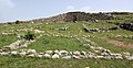
A warped rectangle called Taanıkkaya can be seen on the western side of the street, which was framed by the city wall. On its plateau-like surface, two large buildings in the middle of an open space could probably be identified by geomagnetic investigations . Nothing can be said about their function without excavations.

Remains of the possible rock summit house

Floor plans of the square houses west of Sarıkale
Ceramic vessel from the house of the MESCHEDI commandant


Yenicekale

The road now reaches the southern city wall, where the Löwentor is located after a short distance. Opposite, about 150 meters northeast and thus about halfway between Löwentor and Sarıkale, is the rocky hill Yenicekale. On its surface, a plateau of about 25 × 28 meters was smoothly worked off from the rock. On the sides it was enlarged by masonry with massive limestone blocks. Few remnants of the rising masonry can be seen on this artificial building platform, which hardly allow any conclusions to be drawn about the buildings erected on it. One can only speculate about the function, it could also have been one of the mentioned rock summit houses .
Between Löwentor and Yenicekale, a little east of the gate, the restored foundation walls of a temple, called Temple 30, can be seen. In the last decades of the empire it was built over by pottery workshops.
Another 200 meters further east were the so-called southern ponds in Hittite times. There was initially in the middle of the 16th century BC. A large, underground granary was created. In the same century it was replaced by five ponds. They were kept relatively narrow in order to keep the evaporation loss low, but had a depth of up to eight meters. To minimize the risk of dam breaks or contamination, the water reservoir was divided into five ponds. After initially assuming that the ponds were fed by springs in the higher area, Andreas Schachner and Hartmut Wittenberg determined in an investigation in the 2010s that on the one hand this would have meant technical problems and probably would not have been sufficient. Instead, they assume a filling by infiltration from groundwater horizons, which were cut by the Hittite engineers. The stone-lined edges of the southern ponds can now be seen in the area.
Yenicekale from the southeast, in the foreground Temple 30

Temple 30, Yenicekale in the background on the right


Yerkapı

From the Löwentor to the west, the street runs parallel to a high, artificially raised wall, on the crown of which the city wall stretches along. The Turkish name of the wall Yerkapı (German for about gate in the ground ) is derived from the postern, which leads under the highest point of the wall, below the sphinx gate, through the wall to the outside. It is the only postern of Ḫattuša that is still accessible. The tunnel is 71 meters long and has a clear gradient to the outside. It is built using the corbel technique and is a little over three meters high. The floor was covered with white screed, which reflected the little incident light. On the inside, below the Sphinx Gate, the entrance is integrated into the steep slope, the exit is built into the ramp there as a massive structure. Both sides were once lockable with double-leaf doors. Nothing can be said about the function of the passage; it certainly did not represent a port of departure that was not so clearly laid out. From the outside, the wall is about 30 meters high and was covered with stone paving over a width of 250 meters. Vertical grooves for draining rainwater were worked into the pavement at intervals of 21 meters. Large areas of the stones are missing today, they were built in the late phase of the city for the second, upstream city wall on the top of the rampart. At both ends in the west and east, stairs lead to the height of the wall, which is why the wall gives the appearance of a cut pyramid from a distance.
A military function can be excluded for the mighty wall. The clearly visible exit of the postern and the stairs on both sides of the ramp speak against this. The incline of 35 degrees would have been an easy obstacle to overcome for a trained warrior. Peter Neve and his successors as excavators Seeher and Schachner consider the wall to be a possible stage for ceremonial and cult performances. In addition, there is the impressive effect of the monumental structure on delegations arriving from the south. From the north, the crowning glory of the city could already be seen from a distance of 20 kilometers, which in Hittite times was more than a day's journey.
Eastern stairs
Upper entrance of the postern
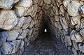
Inside of the postern with cantilever vault

Exit structure of the postern


Temple District

If you look north from the Sphinx Gate to the city, you can see a wide valley in the foreground, which is bordered by Sarıkale and Yenicekale to the west and by the modern road to the east. In the valley there are numerous building plans that were originally only temples. In the central area 24 temples were excavated, in addition there are temple 30 at the lion gate, temple 7 on the eastern slope of Sarıkale and in the east to the king gate the three somewhat remote temples 3, 2 and 5. Their sizes are very different and vary between 400 and 1500 square meters, but their structure is similar to each other. In all of them, one enters an open courtyard through a gate with adjoining rooms, on the side of which (mostly opposite) a portico leads into the Adyton , the Holy of Holies. There was a statue of the worshiped deity on a pedestal. Some of the temples (4, 6, 26 and 5) are surrounded by a temenos that was delimited by a wall. The largest temple is Temple 5, which is located a little to the east of the actual district in the immediate vicinity of the King's Gate. It is only slightly smaller than the Great Temple in the Lower City and, like it, has two holy of holies as well as a small altar-like building in one corner in the central courtyard.
The large number of temples testifies to the numerous gods of the Hittite pantheon . Hittite texts speak of the thousand gods of the Hatti land . This is also due to the fact that the Hittites brought the local deities with them, including their images, from all newly conquered countries or cities and integrated them into their religion. It is believed that other temples existed in the upper town. The scanty finds in the temple rooms do not allow any conclusions to be drawn as to which gods they were consecrated to. In one of the outbuildings of Temple 5, a stele with a relief of Tudḫaliya in warrior clothing came to light, but without any indication as to which of the great kings of this name might be meant. Research over the past decades has shown that, contrary to earlier research opinion, at least some of the temples were built as early as the 16th century BC. Was built. In doing so, Andreas Müller-Karpe relies on comparisons with temples in Kuşaklı , which could be dated using dendrochronology . At the end of the 13th century BC Because of external threats, residents who had previously lived outside the city withdrew behind the walls. Large parts of the temple district were built over with residential buildings and, above all, workshops. Irregular floor plans of these buildings can be seen in the southern part of the quarter. Schachner believes it is possible that these changes were due to the relocation of the capital under Muwatalli II at the beginning of the 13th century BC. BC, according to his own statement with the gods , go back. Similar wall remnants in the northern area are relics from even later, Byzantine times, including a church in the area of Temple 16.

Western part, behind Temple 16 with Byzantine church

Temple 4 with Temenos

Temple 3 (front) and 2

Temple 5


Südburg and Ostteiche

At the Königstor the road leaves the course of the city wall and turns back down the slope to the northwest. After about 300 meters, the edges of the former eastern ponds can be seen east of the road. Large parts of the city could be supplied with water from the ponds. The western one has dimensions of 60 × 90 meters, the eastern one should have been about the same size. The soil was sealed with a water-impermeable layer of clay, the paved side embankments were secured by ditches behind with a similar layer. The east ponds, like the south ponds, were filled by infiltrating groundwater (see there).
In addition to the water supply, the ponds had a cultic function. Stone chambers with a parabolic vault were built at the two north-western corners of the west pond. Chamber 1 is right on the street, about three meters high and four meters deep. The chambers were integrated into an earth dam that marked the northwest end of the pond. At the other end, the second chamber could be excavated. It is decorated with a relief of the sun god on the back wall. On the left wall there is a stone with a relief of Šuppiluliuma. Presumably it is Šuppiluliuma II. , The last known ruler of the Hittite Empire. That he is the builder of the chamber is evident from an inscription in Luwian hieroglyphics that occupies the entire right wall of the chamber. In the text, the great king reports on campaigns and the founding of cities in western Anatolia. He also boasts of here a divine earth path ( divine earth road in the translation of John David Hawkins to have) created what the cuneiform in hieroglyphics DEUS.VIA + TERRA DINGIR corresponds KASKAL.KUR. In connection with a temple (31) on the plateau north of the chambers, the chambers and the ponds are referred to as a cult area. The establishment probably falls in the late 13th century BC. Chr.
This plateau was used by the city's residents in the Iron Age, in the 7th century BC. To build a fortified settlement. This is referred to in the literature as the south castle. The settlement was surrounded by massive walls and could only be entered through a gate with two towers in the west of the complex. There were residential buildings, workshops and storage rooms in the settlement. At the same time there were settlements in parts of the lower town and on the nearby Büyükkale. In the northern half of the plateau are the remains of the Hittite temple 31.

Chamber 1
South castle, Phrygian buildings, hieroglyphic chamber at the back 2

Relief of the Šuppiluliuma

inscription


Nişantepe

Another prominent rock is the Nişantepe on the opposite, western side of the road. The hill got its name (German sign hill ) after a large hieroglyphic inscription on its northeast side, which is called Nişantaş ( sign stone ). An eleven-line inscription in the bustrophedon style is carved on a smooth inclined rock surface 9 meters long and 2.40 meters high . Due to the weather, the characters made in high relief are very difficult to read. The top line, which was a little more protected by a rocky promontory, names Šuppiluliuma with his titulature as the great king and his descent as the son of Tudḫaliya IV and grandson of Ḫattušili III. Since this is followed by the name of the father again, it is assumed that the Great King is reporting here about the deeds of Tudḫaliya. Perhaps Šuppiluliuma also describes the construction of a memorial for his father, namely Chamber B in the rock sanctuary of Yazılıkaya.
Faint traces of a building can be seen on the top of the Nişantepe Rock, possibly a rock summit house . It was entered via a ramp, at the top of which there was a gate with a parabolic dome, which was guarded on both sides by sphinx figures similar to those at the Sphinx Gate. Remains of these figures were found in the rubble that fell at the foot of the hill and are now on display in the local museum. In the flat area north in front of the rock ridge, a restored floor plan can be seen, the so-called north building . In another building to the west, called the West Building, several thousand bullae and some clay tablets were found. Schachner therefore sees the building as an administration building. One can only speculate about the purpose of the other buildings.

Detail of the inscription

North building

Torsphinx from the building on Nişantepe (Museum Boğazkale)


Buyukkale

Opposite, on the northeast side of the road, is the Büyükkale hill, which for a long time was one of the centers of settlement in Boğazköy. It is oriented southwest-northeast, its surface has a size of about 260 × 150 meters. The highest point is a rock barrier in the northeast with a height of 1128 meters above sea level. The elevation had been settled at least since the end of the Early Bronze Age, and storage pits in the south can be proven to have originated before 2000 BC. The settlement was already around 1900 BC. Attached. As Ḫantili I. at the turn of the 17th to the 16th century BC BC built the first wall around the city, the fortification of Büyükkale was integrated into it. After several destruction, Ḫattušili III. and his son Tudḫaliya IV. a fortified monumental palace complex. It was entered in the southwest, where a modern staircase leads to the plateau, via a viaduct that could also be used by wagons. The complex consisted of three courtyards, which were separated by walls with gates decorated with lions. In addition, there were administrative buildings, the teams' common rooms, archives, a reception hall, probably also religious buildings and the palace of the great king. Over 4,000 cuneiform tablets were found in several buildings, as well as steles, fragments of gate lions and other works of art came to light. Büyükkale was also in the post-Hittite period from the 8th to the 6th century BC. Colonized, partly fortified, from the Phrygian to the Hellenistic-Roman period. Only individual finds came to light from later, Byzantine, Seljuk and Ottoman times.
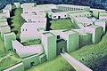
reconstruction

Büyükkale from the south

Old Ethite relief with battle scenes, from above from the carriage, below on foot (Museum Boğazkale)

Bull vessels ( Museum of Anatolian Civilizations ) in Ankara

Statue of Cybele from the southeast gate of the Phrygian fortifications (Ankara Museum)
.jpg)


.jpg)

Ambarlıkaya, Büyükkaya and Mihraplıkaya

Before Büyükkale, the road turns down the northwest slope and follows the postern wall. About halfway to Kesikkaya, on the right, on the north side of the wall, was a large underground granary made up of 32 individual, rectangular containers. It was partially dug up by Jürgen Seeher and, according to the documentation, was backfilled to protect it from the weather and is therefore no longer visible. Before Kesikkaya, the road joins the driveway from the entrance and soon reaches the Great Temple again. Opposite this, in the northeast of the city, you can see the two large elevations Ambarlıkaya and Büyükkaya. On the summit of Ambarlıkaya, clear traces of rock cut-offs can be seen, which suggest a monumental building. Structural traces of it have not been preserved. Ambarlıkaya lies in front of the northern steep slope of Büyükkale and is separated from Büyükkaya further north by a deep gorge through which the Büyükkaya Deresi flows. The city wall ran down from Büyükkale on the slope of Ambarlıkaya and further through the gorge, where it stopped at the stream. This was possibly secured by a stable grid. The extremely steep southern slope of Büyükkaya was undeveloped, only at the height of the plateau did the wall begin again and continued northward, where it finally enclosed the northern part of the city. Another wall was later connected to the first, which branched off in the north of the elevation, ran west and met again with the western section wall of the lower town. This turned the ridge into a fortress of its own. The restored walls and the posterns on the east side of Büyükkaya are easy to see.
The Büyükkaya hill, stretching from south-north, is around 500 meters long, while the steep rock face in the west rises 100 meters above the course of the stream. Büyükkaya was the part of Boǧazköy that was settled first. A settlement from at least the 5th millennium BC BC is proven by scientific dating. Remains of buildings from the early Bronze Age were found in the late 3rd millennium BC. In addition to residential buildings, furnaces, molds and various devices are used in metalworking. Also from the Karum time at the beginning of the 2nd millennium BC Traces of residential houses were found. In the Hittite period, there was initially a monumental building here, but only the foundations have been preserved. In the 14th century BC A large grain store was set up on the summit. So far, eleven rectangular pits have been excavated, the largest of which is 12 × 18 meters in size and over two meters deep. At least 260 tons of grain could be stored in it alone. After the end of the Hittite Empire, there was still a settlement on Büyükkaya. It could have been the remaining Hittites, just as possible are elements of the population who immigrated from the north and took possession of the abandoned city. The residents lived in pit houses and fell back to the Stone Age, scriptless level. With the middle Iron Age from the late 8th century BC BC, when parts of the urban area were repopulated, the traces of Büyükkaya are lost. Only from the 3rd century BC Chr. Individual graves and litter finds are to be proven again.
Where the area around the stream northwest of Ambarlıkaya and Büyükkaya slowly merges into the plain, another, smaller rock breaks through the ground. It is named Mihraplıkaya (roughly rock with a prayer niche ) because of a semicircular niche carved into its north side. It was initially regarded as the apse of a Byzantine church, which existed around the 10th to 11th centuries and is seen in connection with the simultaneous settlement in the area of Sarıkale and the temple district. The area west of Mihraplıkaya has been an object of excavations in Boǧazköy since 2014. So far, a monumental building from the Roman imperial era came to light that overbuilt a previous Roman fortification. This lavishly furnished building is complemented in the east, at Mihraplıkaya, by a 45 × 20 meter large water basin and a festival building with wall paintings, which was oriented towards the niche in the rock. The interpretation of the niche as a church apse is therefore no longer considered likely. The course of the section walls in the area could also be redefined.

Büyükkaya from the west

Büyükkaya from the south, in the foreground the temple district and Büyükkale

Büyükkaya from the east


Yazılıkaya

About 1.5 kilometers east of the city is the rock sanctuary of Yazılıkaya. Over 80 reliefs are carved into the walls of two rock chambers. These include two processions of members of the Hittite pantheon and several depictions of King Tudḫaliya IV. He may have been buried in the smaller chamber B. In front of the chambers, the foundation walls of a building have been excavated, which made the sanctuary a closed sacred area. The place was probably used as a place of worship, at least as a burial place, as early as the Old Ethite period. The decoration with the reliefs was not made until the 13th century BC. Under Tudḫaliya IV. And his son Šuppiluliuma II. According to Jürgen Seeher's assessment, Yazılıkaya represents a “New Year's festival house, the house of the weather god, in which all the gods unite every year for the New Year and Spring Festival”. On this occasion there was probably a procession from the Great Temple to the sanctuary, where the Great King was confirmed in office.
Finds
The most noticed part of the finds from the urban area of Ḫattuša are undoubtedly the more than 30,000 fragments of inscribed clay tablets in Hittite, Assyrian and several other languages. They were added to the list of UNESCO World Heritage Sites in 2001. The best-known text among them is the Akkadian version of the Egyptian-Hittite peace treaty , dated 1259 BC. Between Ḫattušili III. and the Egyptian pharaoh Ramses II . Despite some opposing opinions, it is generally regarded as the oldest known written parity peace treaty in history. A copy of the contract text has been on display in the UN building in New York since 1972 thanks to a foundation from Turkey. Also important for research are, among other things, the text of a contract between Tud .aliya IV and Kurunta , which regulates his position and rule over the Tarḫuntašša region , as well as the Mešedi text (also MESCHEDI), a service regulation for employees of the Palace. The latter regulated the duties of the royal guard and provides important information about the structure and organization of Hittite rulers' residences and cities in general. The majority of the cuneiform tablets are kept or exhibited in the Istanbul Archaeological Museum and the Museum of Anatolian Civilizations in Ankara as well as in the local museum in Boğazkale. Other finds besides architectural fragments are steles, household goods and other ceramics as well as smaller works of art such as statuettes and cult vessels. Larger works of art, such as statues of rulers or images of gods, were not found; they were probably taken away when leaving the city after the fall of the empire. The finds can be seen in the museums mentioned as well as in the Archaeological Museum in nearby Çorum and in the Museum of Boğazkale. The copies of the reliefs by Yazılıkaya made in 1882 are shown in the Vorderasiatisches Museum Berlin .
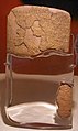
Egyptian-Hittite Peace Treaty, Istanbul Museum

Bronze plaque with the treaty between Tudḫaliya IV and Kurunta, Ankara Museum

Tudḫaliyas IV stele, Çorum Museum

Statuette of a mountain god, ivory, height 3.6 cm, Ankara Museum


literature
- Bogazkoy-Hattusa. Results of the excavations of the German Archaeological Institute and the German Orient Society. 21 volumes. Gbr. Mann, Berlin 1952 ff., Zabern, Mainz 1996 ff. ISSN 0342-4464 .
- Kurt Bittel : Hattuscha - capital of the Hittites. History and culture of an ancient oriental great power. DuMont, Cologne 1983, ISBN 3-7701-1456-6 (3rd edition, ibid 1991)
- Peter Neve : Hattusa - city of gods and temples. New excavations in the capital of the Hittites. 2nd Edition. Zabern, Mainz 1996, ISBN 3-8053-1478-7 .
- Walter Dörfler and others: Studies on the cultural history and agricultural economy in the catchment area of Hittite cities. In: MDOG . Berlin 132.2000, ISSN 0342-118X , pp. 367-381.
- The Hittites and their empire - the people of 1000 gods. Exhibition catalog. The Hittites. The people of 1000 gods from January 18 to April 28, 2002 in the art and exhibition hall of the Federal Republic of Germany in Bonn. Theiss, Stuttgart 2002, ISBN 3-8062-1676-2 .
- Silvia Alaura: “To Boghasköi!” On the prehistory of the excavations in Boğazköy-Hattusa and on the archaeological research up to the First World War , 13th broadcast of the German Orient Society. Harrassowitz 2006 ISBN 978-3-00-019295-1 .
- Jürgen Seeher : The adobe city wall of Hattusa. Reconstruction report. Ege Yayınları, Istanbul 2007, ISBN 978-975-8071-94-4 .
- Hattusa In: Trevor Bryce : The Routledge Handbook of the Peoples and Places of Ancient Western Asia. The Near East from the Early Bronze Age to the Fall of the Persian Empire , Routledge, London et al. 2009. ISBN 978-0-415-39485-7 pp. 298-304
- Jürgen Seeher: Hattuscha leader. A day in the Hittite capital. 4th, revised edition. Ege Yayınları, Istanbul 2011, ISBN 978-605-5607-57-9 .
-
Andreas Schachner : Working reports in the Archäologische Anzeiger (AA)
- The excavations in Boğazköy-Hattuša 2006 , in AA 2007/1, pp. 67–93 ( online )
- The excavations in Boğazköy-Hattuša 2007 , in AA 2008/1, pp. 113–161 ( abstract , online )
- The excavations in Boğazköy-Ḫattuša 2008 , in AA 2009/1, pp. 21–72 ( abstract ), ( online )
- The excavations in Boğazköy-Hattuša 2009 , in AA 2010/1, pp. 161–221 ( abstract ), ( online )
- The excavations in Boğazköy-Hattuša 2010 , in AA 2011/1, pp. 31–86 ( online )
- The excavations in Boğazköy-Ḫattuša 2011 , in AA 2012/1, pp. 85-137 ( abstract , online )
- The work in Boğazköy-Ḫattuša 2012 , in AA 2013/1, pp. 147–193 ( abstract , online )
- The excavations in Boğazköy-Ḫattuša 2013 , in AA 2014/1, pp. 93–168 ( abstract , online )
- The excavations in Boğazköy-Ḫattuša 2014 , in AA 2015/1, pp. 69-107 ( abstract , online )
- The excavations in Boğazköy-Hattuša 2015 , in AA 2016/1, pp. 1–47 ( abstract , online )
- The excavations in Boğazköy-Hattuša 2017 , in AA 2018/1, pp. 1–72 ( online )
- Andreas Schachner: Hattuscha. In search of the legendary empire of the Hittites. CH Beck, Munich 2011, ISBN 978-3-406-60504-8 .
- Andreas Schachner: Hattusa - capital of the Hittites. Origin, development and decline of a Bronze Age metropolis. In: Antike Welt 1/2012, pp. 8–15 ( online )
- Andreas Schachner: The excavations in the lower town of Ḫattusa (2009-2014): First preliminary results , in: A. D'Agostino, V. Orsi, G. Torri (eds.): Sacred Landscapes of the Hittites and Luwians , Studia Asiana 9, Florence 2015, pp. 67–81 ( online )
- Andreas Schachner: Boğazköy-Hattuša: Review and Perspectives In: Ünsal Yalcin, Hans-Dieter Bienert (ed.), Anatolien - Brücke der Kulturen. Current research and perspectives in German-Turkish classical studies, Der Anschnitt 27 (Bochum 2015) ISBN 978-3-937203-75-1 . Pp. 217-230. ( online )
Web links
- Hattuscha on the DAI website
- Virtual tour
- What a dinner service from Anatolia tells of the life of the Hittites - an enigmatic high culture in the Antike Berliner Zeitung, November 8, 2008
- Entry on the website of the UNESCO World Heritage Center ( English and French ).
- Photo series for Ḫattuša and Yazılıkaya ch-forrer.ch (private website with 90 pictures)
Individual evidence
- ↑ Dirk Paul Mielke: Hittite Cities: Looking for a Concept In: Herrmann Genz, Dirk Paul Mielke (Eds.): Insights into Hittite History and Archeology . Peeters 2011 p. 183.
- ↑ Andreas Schachner: Hattuscha - In search of the legendary Hittite Empire , Beck, Munich 2011, ISBN 978-3-406-60504-8 , p. 241.
- ↑ Kurt Bittel : Boğazköy Führer, Ankara 1972 p. 3.
- ↑ If the Hittite capital is not explicitly mentioned, but the place where it was found, the name Boǧazköy is used in the following, as is customary in literature .
- ^ DAI - Hattusa / Boğazköy
- ↑ UNESCO World Heritage List
- ^ Memory of the World
- ↑ Kurt Bittel : Boğazköy Führer, Ankara 1972 pp. 3-4.
- ↑ Andreas Schachner: Hattusa and its Environs: Archeology In: Mark Weeden, Lee Z. Ullmann (Ed.): Hittite Landscape and Geography. Brill Leiden / Boston 2017 pp. 37–49.
- ↑ a b Andreas Schachner: Hattuscha - In search of the legendary Hittite Empire , Beck, Munich 2011, ISBN 9783406605048 , pp. 33–40.
- ↑ Andreas Schachner: Hattuscha - In search of the legendary Hittite Empire , Beck, Munich 2011, ISBN 9783406605048 , p. 341.
- ↑ Jürgen Seeher: Hattuscha guide. A day in the Hittite capital. 4th, revised edition. Ege Yayınları, Istanbul 2011, ISBN 978-605-5607-57-9 p. 60.
- ^ Rainer Pasternak: Preliminary report on the archaeobotanical work in Ḫattuša 2009–2011 In: Archäologischer Anzeiger 1/2012 pp. 110–114.
- ↑ a b Andreas Schachner: Hattuscha - In search of the legendary Hittite Empire , Beck, Munich 2011, ISBN 978-3-406-60504-8 , pp. 284–287.
- ↑ Jürgen Seeher: Hattuscha guide. A day in the Hittite capital. 4th, revised edition. Ege Yayınları, Istanbul 2011, ISBN 978-605-5607-57-9 pp. 118–121.
- ^ Andreas Schachner: Hattuscha - In search of the legendary Hittite Empire , Beck, Munich 2011, ISBN 978-3-406-60504-8 , pp. 288-292.
- ↑ Andreas Schachner: Hattuscha - In search of the legendary Hittite Empire , Beck, Munich 2011, ISBN 978-3-406-60504-8 , p. 241.
- ↑ a b c d Jürgen Seeher: Hattuscha guide. A day in the Hittite capital. 4th, revised edition. Ege Yayınları, Istanbul 2011, ISBN 978-605-5607-57-9 pp. 180-181.
- ↑ Jürgen Seeher: Gods carved in stone. The Hittite rock sanctuary of Yazılıkaya. Ege Yayınları Publishing House, Istanbul 2011, ISBN 978-605-56-0753-1 , pp. 175ff.
- ↑ a b c Project Hattusa / Boğazköy website of the DAI, see research history in the history section .
- ↑ Silvia Alaura: “To Boghasköi!” On the prehistory of the excavations in Boğazköy-Hattusa and on the archaeological research up to the First World War , 13th broadcast of the German Orient Society. Harrassowitz 2006 ISBN 978-3-00-019295-1 pp. 43-50.
- ↑ Royal Citadel in Hattusa turkisharchaeonews.net (English), with pictures
- ↑ Further work by the DOG in Hattuscha orient-gesellschaft.de
- ↑ Bogazkoy-Hattusa. Results of the excavations of the German Archaeological Institute and the German Orient Society. 21 volumes. Gbr. Mann, Berlin 1952 ff., Zabern, Mainz 1996 ff. ISSN 0342-4464 .
- ^ Project Hattusa / Boğazköy website of the DAI, see section Research . Quote: "On the one hand, large areas of the city are still completely unknown, on the other hand, residential areas in particular have only been rudimentarily examined in previous research."
- ↑ a b c Jürgen Seeher: A piece of the city wall in Hattuša archaeologie-online.de, May 22, 2008
- ↑ Ulf-Dietrich Schoop: Çamlıbel Tarlası, a metal processing site of the fourth millennium BC In northern Central Anatolia In: Ünsal Yalçın (Ed.): Anatolian Metal V , Bochum 2011 ISBN 978-3-937203-54-6 pp. 53–68
- ↑ Double award-winning: Two DAI projects receive the Shanghai Archeology Award 2019. German Archaeological Institute, November 13, 2019, accessed on November 15, 2019 .
- ↑ Andreas Schachner: Hattuscha - In search of the legendary Hittite Empire , Beck, Munich 2011, ISBN 978-3-406-60504-8 , pp. 41–43.
- ↑ Andreas Schachner: Hattuscha - In search of the legendary Hittite Empire , Beck, Munich 2011, ISBN 978-3-406-60504-8 , pp. 43–49.
- ↑ Andreas Schachner: Hattuscha - In search of the legendary Hittite Empire , Beck, Munich 2011, ISBN 978-3-406-60504-8 , pp. 49-55.
- ↑ Jürgen Seeher: Hattuscha guide. A day in the Hittite capital. 4th, revised edition. Ege Yayınları, Istanbul 2011, ISBN 978-605-5607-57-9 pp. 159-160.
- ↑ Andreas Schachner: Hattuscha - In Search of the Legendary Hittite Empire , Beck, Munich 2011, ISBN 978-3-406-60504-8 , pp. 56–68.
- ↑ Jürgen Seeher: Hattuscha guide. A day in the Hittite capital. 4th, revised edition. Ege Yayınları, Istanbul 2011, ISBN 978-605-5607-57-9 pp. 160-161.
- ↑ Andreas Schachner: Hattuscha - In search of the legendary Hittite Empire , Beck, Munich 2011, ISBN 978-3-406-60504-8 , p. 68.
- ↑ a b Andreas Schachner: Hattuscha - In search of the legendary Hittite Empire , Beck, Munich 2011, ISBN 978-3-406-60504-8 , pp. 71–74.
- ↑ Einar von Schuler : The Kaškäer. A contribution to the ethnography of ancient Asia Minor (= supplementary volume 3 to the journal for Assyriology and Near Eastern Archeology ). de Gruyter, Berlin 1965. p. 19.
- ↑ Jürgen Seeher: Hattuscha guide. A day in the Hittite capital. 4th, revised edition. Ege Yayınları, Istanbul 2011, ISBN 978-605-5607-57-9 p. 164.
- ↑ Andreas Schachner: Hattuscha - In search of the legendary Hittite Empire , Beck, Munich 2011, ISBN 978-3-406-60504-8 , pp. 75–82.
- ↑ Jürgen Seeher: Hattuscha guide. A day in the Hittite capital. 4th, revised edition. Ege Yayınları, Istanbul 2011, ISBN 978-605-5607-57-9 p. 164.
- ↑ Andreas Schachner: Hattuscha - In search of the legendary Hittite Empire , Beck, Munich 2011, ISBN 978-3-406-60504-8 , pp. 82–94.
- ↑ a b Andreas Schachner: Hattuscha - In Search of the Legendary Hittite Empire , Beck, Munich 2011, ISBN 978-3-406-60504-8 , pp. 94–98.
- ↑ Jürgen Seeher: Hattuscha guide. A day in the Hittite capital. 4th, revised edition. Ege Yayınları, Istanbul 2011, ISBN 978-605-5607-57-9 pp. 166-168.
- ^ John David Hawkins : The Hieroglyphic Inscriptions of the Sacred Pool Complex at Hattusa (Südburg). (= Studies on the Boǧazköy texts. Supplement 3). Harrassowitz, Wiesbaden 1995, ISBN 3-447-03438-6 p. 44.
- ↑ Andreas Schachner: Hattuscha - In Search of the Legendary Hittite Empire , Beck, Munich 2011, ISBN 978-3-406-60504-8 , pp. 104-109.
- ↑ Andreas Schachner: Hattuscha - In search of the legendary Hittite Empire , Beck, Munich 2011, ISBN 978-3-406-60504-8 , pp. 109–114, 345.
- ↑ Birgit Brandau, Hartmut Schickert: Hittiter - The unknown world power. 2nd Edition. Munich 2002, ISBN 3-492-04338-0 pp. 326-332.
- ↑ Jürgen Seeher: The Destruction of the City of Ḫattuša In: Gernot Wilhelm (Hrsg.): Files of the IV. International Congress for Hittitology Würzburg, 4.-8. October 1999 . Harrassowitz Verlag Wiesbaden 2001 pp. 623–634.
- ↑ Trevor Bryce : The World of The Neo-Hittite Kingdoms. A Political and Military History , Oxford University Press, 2012. ISBN 978-0-19-921872-1 p. 10.
- ↑ Zsolt Simon: The ANKARA silver bowl and the end of the Hittite empire In Zeitschrift für Assyriologie und Vorderasiatische Aräologie Vol. 99 pp. 247–269, here pp. 259–261.
- ↑ Jürgen Seeher: Hattuscha guide. A day in the Hittite capital. 4th, revised edition. Ege Yayınları, Istanbul 2011, ISBN 978-605-5607-57-9 p. 171.
- ↑ Andreas Schachner: Hattuscha - In search of the legendary Hittite Empire , Beck, Munich 2011, ISBN 978-3-406-60504-8 , p. 313.
- ↑ Jürgen Seeher: Hattuscha guide. A day in the Hittite capital. 4th, revised edition. Ege Yayınları, Istanbul 2011, ISBN 978-605-5607-57-9 pp. 170-174.
- ↑ Andreas Schachner: Hattuscha - In search of the legendary Hittite Empire , Beck, Munich 2011, ISBN 978-3-406-60504-8 , pp. 109–114, 331.
- ↑ a b Andreas Schachner: Hattuscha - In Search of the Legendary Hittite Empire , Beck, Munich 2011, ISBN 978-3-406-60504-8 , pp. 109–114, 332–339.
- ↑ Jürgen Seeher: Hattuscha guide. A day in the Hittite capital. 4th, revised edition. Ege Yayınları, Istanbul 2011, ISBN 978-605-5607-57-9 pp. 175-176.
- ↑ Andreas Schachner: Hattuscha - In Search of the Legendary Hittite Empire , Beck, Munich 2011, ISBN 978-3-406-60504-8 , pp. 109–114, 338–341.
- ↑ DAI - Hattusa / Boğazköy - The City Wall (Section Results)
- ↑ Andreas Schachner: Hattuscha - In search of the legendary Hittite Empire , Beck, Munich 2011, ISBN 978-3-406-60504-8 , pp. 71–82.
- ↑ Jürgen Seeher: Hattuscha guide. A day in the Hittite capital. 4th, revised edition. Ege Yayınları, Istanbul 2011, ISBN 978-605-5607-57-9 pp. 29-30.
- ↑ a b Andreas Schachner: Hattuscha - In search of the legendary Hittite Empire , Beck, Munich 2011, ISBN 978-3-406-60504-8 , pp. 154–164.
- ↑ Hattusha: the Hittite Capital website of UNESCO (English)
- ↑ a b Jürgen Seeher: Hattuscha guide. A day in the Hittite capital. 4th, revised edition. Ege Yayınları, Istanbul 2011, ISBN 978-605-5607-57-9 pp. 57-58.
- ↑ a b Andreas Schachner: Hattuscha - In search of the legendary Hittite Empire , Beck, Munich 2011, ISBN 978-3-406-60504-8 , p. 126.
- ↑ Birgit Brandau, Hartmut Schickert: Hittiter - The unknown world power. 2nd Edition. Munich 2002, ISBN 3-492-04338-0 p. 311.
- ↑ a b c d Excavations in Hattusa / Boğazköy - sub-project city wall dainst.org
- ↑ Andreas Schachner: Hattuscha - In search of the legendary Hittite Empire , Beck, Munich 2011, ISBN 978-3-406-60504-8 , p. 158.
- ↑ Jürgen Seeher: Hattuscha guide. A day in the Hittite capital. 4th, revised edition. Ege Yayınları, Istanbul 2011, ISBN 978-605-5607-57-9 p. 32.
- ↑ Jürgen Seeher: Hattuscha guide. A day in the Hittite capital. 4th, revised edition. Ege Yayınları, Istanbul 2011, ISBN 978-605-5607-57-9 pp. 37–45.
- ↑ Thomas Staemmler: Restoration contributions to the preservation of the sculptures and stone in Ḫattuša . In: Archäologischer Anzeiger 1/2011 pp. 64–73.
- ↑ Jürgen Seeher: Hattuscha guide. A day in the Hittite capital. 4th, revised edition. Ege Yayınları, Istanbul 2011, ISBN 978-605-5607-57-9 pp. 58–63.
- ↑ Metin Alparslan: A hieroglyphic Luwian graffito on one of the sphinxes at the Sphinx gate. In: Archäologischer Anzeiger 2013/1 pp. 174–175.
- ↑ The wing part with the inscription could apparently not be inserted properly and is kept separately in the museum, see Metin Alparslan: A hieroglyphic Luwian graffito on one of the sphinxes at the Sphinx gate. In: Archäologischer Anzeiger 2013/1 p. 175, footnote 115
- ↑ Susanne Güsten: Turkish ultimatum: Berlin should return the Sphinx. In: Der Tagesspiegel , February 24, 2011.
- ↑ a b Hermann Parzinger: There must be a just solution faz.net, March 2, 2011.
- ^ Neumann: When the Sphinx is returned, gesprächsready berlin.de, March 6, 2011.
- ↑ Germany returns the Sphinx to Turkey faz.net, May 15, 2011, accessed on February 5, 2013.
- ↑ Sphinx is back in Turkey . n-tv, July 27, 2011, accessed February 5, 2013.
- ↑ Hattuşa reunites with sphinx hurriyetdailynews.com, November 18, 2011.
- ^ Photograph of the two original restored sphinxes in the Museum of Boğazkale (livius.org).
- ^ Photograph of the Sphinx returned in July 2011 in the Museum of Boğazkale.
- ↑ Berlin gets "new" Sphinx from Hattuscha augsburger-allgemeine.de, July 28, 2011.
- ↑ Jürgen Seeher: Hattuscha guide. A day in the Hittite capital. 4th, revised edition. Ege Yayınları, Istanbul 2011, ISBN 978-605-5607-57-9 pp. 76–83.
- ↑ a b c Andreas Schachner: Hattuscha - In search of the legendary Hittite Empire , Beck, Munich 2011, ISBN 978-3-406-60504-8 , pp. 124-131.
- ↑ Jürgen Seeher: Hattuscha guide. A day in the Hittite capital. 4th, revised edition. Ege Yayınları, Istanbul 2011, ISBN 978-605-5607-57-9 p. 7.
- ↑ Jürgen Seeher: Hattuscha guide. A day in the Hittite capital. 4th, revised edition. Ege Yayınları, Istanbul 2011, ISBN 978-605-5607-57-9 p. 8.
- ↑ Kurt Bittel: Boğazköy Führer, Ankara 1972 p. 37.
- ↑ Melanie Meißner, Thomas Staemmler, Andreas Schachner: Das Löwenbecken In: Archäologischer Anzeiger 1/2018 pp. 39–41.
- ↑ Andreas Schachner: Hattuscha - In search of the legendary Hittite Empire , Beck, Munich 2011, ISBN 978-3-406-60504-8 , p. 182.
- ↑ a b c Jürgen Seeher: Hattuscha guide. A day in the Hittite capital. 4th, revised edition. Ege Yayınları, Istanbul 2011, ISBN 978-605-5607-57-9 pp. 8-25.
- ↑ Jürgen Seeher: Hattuscha guide. A day in the Hittite capital. 4th, revised edition. Ege Yayınları, Istanbul 2011, ISBN 978-605-5607-57-9 pp. 26-27.
- ↑ Giulia Torri: The phrase ṬUPPU URUH Ḫatti in Colophons from Ḫattuša and the Work of the Scribe Ḫanikkuili In: Altorientalische Forschungen , Akademie Verlag, 38 (2011) 1 pp. 135-144.
- ↑ Reinhard Dittmann: In search of the “lost” architecture of Hattuša - securing evidence. Surface surveys since 2007 Westfälische Wilhelms-Universität Münster. P. 17.
- ↑ Andreas Schachner: Theodor Makridis excavations at Kesikkaya In: Archäologischer Anzeiger 1/2014 pp. 109–112.
- ^ Andreas Schachner: The excavations in the lower town of Ḫattusa (2009-2014); First results In: Anacleto D'Agostini, Valentina Orsi, Giulia Torri (Eds.): Sacred Landscapes of Hittites and Luwians Firenze University Press 2015, ISBN 978-88-6655-903-0 , pp. 67-81.
- ↑ Andreas Schachner: The excavations in Boğazköy-Hattuša 2013. In: Archäologischer Anzeiger 1/2014 pp. 98-103.
- ↑ Reinhard Dittmann , Ulf Röttger: Kızlarkayası In: Archäologischer Anzeiger 1/2010 pp. 183–155.
- ↑ Andreas Schachner: Hattuscha - In search of the legendary Hittite Empire , Beck, Munich 2011, ISBN 978-3-406-60504-8 , p. 168.
- ↑ Jürgen Seeher: Hattuscha guide. A day in the Hittite capital. 4th, revised edition. Ege Yayınları, Istanbul 2011, ISBN 978-605-5607-57-9 pp. 35–37.
- ↑ Reinhard Dittmann: In search of the “lost” architecture of Hattuša - securing evidence. Surface surveys since 2007 Westfälische Wilhelms-Universität Münster. P. 12.
- ↑ Andreas Schachner: Hattuscha - In search of the legendary Hittite Empire , Beck, Munich 2011, ISBN 978-3-406-60504-8 , p. 86.
- ↑ Andreas Schachner: Excavations in the western upper town (grid squares 295–296 / 287) In: Archäologischer Anzeiger 1/2010 pp. 161–164.
- ↑ Andreas Schachner: Hattuscha - In search of the legendary Hittite Empire , Beck, Munich 2011, ISBN 978-3-406-60504-8 , p. 167.
- ↑ Jürgen Seeher: Hattuscha guide. A day in the Hittite capital. 4th, revised edition. Ege Yayınları, Istanbul 2011, ISBN 978-605-5607-57-9 pp. 46–47.
- ↑ Andreas Schachner: Hattuscha - In search of the legendary Hittite Empire , Beck, Munich 2011, ISBN 978-3-406-60504-8 , p. 86.
- ↑ Jürgen Seeher: Hattuscha guide. A day in the Hittite capital. 4th, revised edition. Ege Yayınları, Istanbul 2011, ISBN 978-605-5607-57-9 pp. 48-49.
- ↑ a b Andreas Schachner, Hartmut Wittenberg: On the water reservoirs in Boğazköy / Hattuša and the question of their filling In: Florian Klimscha, Ricardo Eichmann, Christof Schuler, Henning Fahlbusch (ed.): Water management innovations in an archaeological context - From the prehistoric beginnings to to the metropolises of antiquity . Publishing house Marie Leidorf GmbH. ISBN 978-3-86757-385-6 pp. 245-255.
- ↑ Jürgen Seeher: Hattuscha guide. A day in the Hittite capital. 4th, revised edition. Ege Yayınları, Istanbul 2011, ISBN 978-605-5607-57-9 p. 55.
- ↑ Jürgen Seeher: Hattuscha guide. A day in the Hittite capital. 4th, revised edition. Ege Yayınları, Istanbul 2011, ISBN 978-605-5607-57-9 pp. 50–56.
- ↑ Andreas Schachner: Hattuscha - In search of the legendary Hittite Empire , Beck, Munich 2011, ISBN 978-3-406-60504-8 , pp. 160–161.
- ↑ a b c Jürgen Seeher: Hattuscha guide. A day in the Hittite capital. 4th, revised edition. Ege Yayınları, Istanbul 2011, ISBN 978-605-5607-57-9 pp. 64–75.
- ↑ Andreas Schachner: Hattuscha - In search of the legendary Hittite Empire , Beck, Munich 2011, ISBN 978-3-406-60504-8 , pp. 89–90.
- ↑ Andreas Schachner: Hattuscha - In search of the legendary Hittite Empire , Beck, Munich 2011, ISBN 978-3-406-60504-8 , pp. 94–96.
- ↑ a b c Jürgen Seeher: Hattuscha guide. A day in the Hittite capital. 4th, revised edition. Ege Yayınları, Istanbul 2011, ISBN 978-605-5607-57-9 pp. 84–96.
- ^ John David Hawkins : The Hieroglyphic Inscriptions of the Sacred Pool Complex at Hattusa (Südburg). (= Studies on the Boǧazköy texts. Supplement 3). Harrassowitz, Wiesbaden 1995, ISBN 3-447-03438-6 SA. 44.
- ↑ Horst Ehringhaus : Gods, Rulers, Inscriptions - The rock reliefs of the Hittite Empire in Turkey. Philipp von Zabern, Mainz 2005, ISBN 3-8053-3469-9 , p. 32.
- ↑ a b Jürgen Seeher: Hattuscha guide. A day in the Hittite capital. 4th, revised edition. Ege Yayınları, Istanbul 2011, ISBN 978-605-5607-57-9 pp. 98-101.
- ↑ Andreas Schachner: Hattuscha - In search of the legendary Hittite Empire , Beck, Munich 2011, ISBN 978-3-406-60504-8 , p. 149.
- ↑ a b Jürgen Seeher : Hattuscha guide. A day in the Hittite capital . 2. revised Edition. Ege Yayınları Publishing House, Istanbul 2002, ISBN 975-8070-48-7 . Pp. 103-115.
- ^ Peter Neve: Büyükkale - The buildings. Excavations 1954–1966. Berlin 1982, ISBN 978-3-7861-1252-5 , pp. 45-46.
- ^ Peter Neve: Büyükkale - The buildings. Excavations 1954–1966. Berlin 1982, ISBN 978-3-7861-1252-5 , p. 136.
- ^ Peter Neve: Büyükkale - The buildings. Excavations 1954–1966. Berlin 1982, ISBN 978-3-7861-1252-5 , pp. 1-2.
- ↑ Andreas Schachner: Hattuscha - In search of the legendary Hittite Empire , Beck, Munich 2011, ISBN 978-3-406-60504-8 , pp. 234-237.
- ↑ Andreas Schachner: Hattuscha - In Search of the Legendary Hittite Empire , Beck, Munich 2011, ISBN 978-3-406-60504-8 , pp. 169–171.
- ↑ a b Jürgen Seeher : Hattuscha guide. A day in the Hittite capital . 2. revised Edition. Ege Yayınları Publishing House, Istanbul 2002, ISBN 975-8070-48-7 . Pp. 116-121.
- ↑ Andreas Schachner: Hattuscha - In search of the legendary Hittite Empire , Beck, Munich 2011, ISBN 978-3-406-60504-8 , pp. 43–54.
- ↑ Andreas Schachner: Hattuscha - In search of the legendary Hittite Empire , Beck, Munich 2011, ISBN 978-3-406-60504-8 , p. 67.
- ↑ Andreas Schachner: Hattuscha - In search of the legendary Hittite Empire , Beck, Munich 2011, ISBN 978-3-406-60504-8 , pp. 311-315.
- ↑ Andreas Schachner: Hattuscha - In search of the legendary Hittite Empire , Beck, Munich 2011, ISBN 978-3-406-60504-8 , p. 15.
- ↑ Jürgen Seeher : Hattuscha guide. A day in the Hittite capital . 2. revised Edition. Ege Yayınları Publishing House, Istanbul 2002, ISBN 975-8070-48-7 . Pp. 175-177.
- ↑ Dominique Krüger, Sven Kühn, Andreas Schachner: Excavations at the Roman fortifications in the north of the city and on the terrace west of Mihraplıkaya In: Archäologischer Anzeiger 1/2018 pp. 19–38.
- ↑ Jürgen Seeher: Hattuscha-Führer, A day in the Hittite capital. Pp. 122-127.
- ↑ Birgit Brandau, Hartmut Schickert: Hittiter, the unknown world power. P. 73.
- ↑ Jürgen Seeher : Hattuscha guide. A day in the Hittite capital . 2. revised Edition. Ege Yayınları Publishing House, Istanbul 2002, ISBN 975-8070-48-7 . P. 162.
- ^ Memory of the World
- ↑ z. B. Press release of the Cluster of Excellence Religion and Politics at the University of Münster, April 23, 2018 .

Heritage: Historic Areas of Istanbul (1985) | Divriği Great Mosque and Hospital (1985) | Ḫattuša - capital of the Hittites (including Yazılıkaya rock sanctuary ) (1986) | Nemrut Dağı (1987) | Xanthos - Letoon (1988) | Safranbolu Old Town (1994) | Archaeological Site of Troy (1998) | Selimiye Mosque in Edirne (2011) | Neolithic site of Çatalhöyük (2012) | Bursa and Cumalıkızık: the cradle of the Ottoman Empire (2014) | Pergamon and its cultural landscape (2014) | Diyarbakır Fortress and Hevsel Gardens Cultural Landscape (2015) | Ephesus (2015) | Archaeological site of Ani (2016) | Aphrodisias (2017) | Göbekli Tepe (2018)
Cultural / natural heritage: Göreme National Park and the rock structures of Cappadocia (1985) | Ancient City of Hierapolis - Pamukkale (1988)