Kedarnath
| Kedarnath | ||
|---|---|---|
|
|
||
| State : |
|
|
| State : | Uttarakhand | |
| District : | Rudraprayag | |
| Sub-district : | Ukhimath | |
| Location : | 30 ° 44 ′ N , 79 ° 4 ′ E | |
| Height : | 3584 m | |
| Area : | 2.75 km² | |
| Residents : | 612 (2011) | |
| Population density : | 223 inhabitants / km² | |
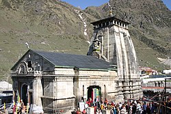
| Kedarnath Temple | ||
Kedarnath ( Hindi : केदारनाथ ) is a small town with a good 600 inhabitants in the Indian state of Uttarakhand ; the nearby Jyotirlinga Temple is one of the most important Hindu pilgrimage sites in all of India.
location
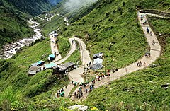
The place and temple of Kedarnath are located in the southern foothills of the Himalaya Mountains at an altitude of approx. 3500 and 3600 m above sea level. d. M. near the source of the Mandakini river. The approx. 15 km long last section from the village of Gaurikund to Kedarnath, which is almost 2000 m high, can only be mastered by means of a helicopter service, on the back of a mule or on foot. The next larger cities are Rishikesh or Haridwar (each about 250 km to the southwest). The climate is cool, but daytime temperatures in summer can reach 20 to 25 ° C; Rain falls mainly in the monsoon months from mid-June to mid-October.
population
About 98% of the population are Hindus ; the rest is made up of Muslims , Christians and others. Less than 1% of local residents are women, which is due to the fact that the place is almost uninhabited in winter and most of the men return to their home villages.
economy
The place lives almost exclusively from inner-Indian pilgrimage tourism. Foreigners rarely find their way here.
history
The place was named after a legendary King Kedar , who is said to have lived in the so-called Golden Age , the Satya Yuga .
On June 17, 2013, the heavy snowmelt in spring and unusually heavy rains caused a rupture of a moraine in the Chorabari glacier, which, as a natural dam, delimited Lake Chorabari , located about 1.5 km above the village of Kedarnath in the Kedarnath valley . About 0.43 million m 3 of water flowed down the valley and carried away masses of debris. Parts of the place were buried and partly destroyed by the water and debris avalanche; more than a thousand people in the region died from the flood. However, the temple remained almost intact.
Attractions
- The Kedarnath Temple , which is one of the four monasteries on the pilgrimage route Chota Char Dham , is one of the most important Jyotirlinga shrines in India. It consists of a vestibule ( mandapa ) built in European style in the 18th century and a cella ( garbhagriha ) raised by a tower ( shikhara ). In front of the temple is the obligatory statue of the Nandi bull.
- Behind the temple is the presumed tomb of Shankara , one of the greatest Hindu saints and philosophers.
- Above Kedarnath there is a lake sacred to Hindus, the Gandhi Sarovar , into which part of the ashes of Mahatma Gandhi was scattered.
- North of the village of Kedarnath is the mountain of the same name .
Web links
Individual evidence
- ^ Kedarnath - dates
- ↑ Kedarnath - Map with altitude information
- ↑ Kedarnath - Climate tables
- ↑ Kedarnath - Census 2011
- ^ Adam Emmer: Glacier Retreat and Glacial Lake Outburst Floods (GLOFs) . In: Oxford Research Encyclopedia of Natural Hazard Science . 2017, doi : 10.1093 / acrefore / 9780199389407.013.275 .


