Rudraprayag (District)
| Rudraprayag District रुद्र प्रयाग जिला |
|
|---|---|

|
|
| State | Uttarakhand |
| Division : | Garhwal |
| Administrative headquarters : | Rudraprayag |
| Area : | 1984 km² |
| Residents : | 242,285 (2011) |
| Population density : | 122 inhabitants / km² |
| Website : | rudraprayag.nic.in |
The district of Rudraprayag ( Hindi : रुद्र प्रयाग जिला ) is a district in the Indian state of Uttarakhand . The seat of the district administration is in Rudraprayag .
geography
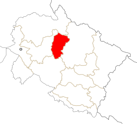
The Rudraprayag district is located in the Garhwal division in the north of Uttarakhand in the Garhwal Himalayas . Rudraprayag borders in the north on Uttarkashi , in the west on Tehri Garhwal , in the south on Pauri Garhwal and in the east on Chamoli . The area of the Rudraprayag district is 1984 km². The Rudraprayag district is traversed by the Mandakini in the north and the Alaknanda in the south . The Rudraprayag administrative center is located at the confluence of the Mandakini with the Alaknanda. The district extends in the north to Mount Kedarnath .
population
According to the 2011 census, the Rudraprayag district has 242,285 inhabitants.
Worth seeing
The Hindu pilgrimage site of Kedarnath is located in the Rudraprayag district .
Web links
Individual evidence
Coordinates: 30 ° 19 ′ N , 79 ° 0 ′ E

