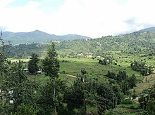
Champawat (District)
| Champawat District चम्पावत जिला |
|
|---|---|

|
|
| State | Uttarakhand |
| Division : | Kumaon |
| Administrative headquarters : | Champawat |
| Area : | 1766 km² |
| Residents : | 259,648 (2011) |
| Population density : | 147 inhabitants / km² |
| Website : | champawat.nic.in |
The Champawat ( Hindi चम्पावत जिला ) district is a district in the Indian state of Uttarakhand . The district administration is based in Champawat . The district was established in 1997.
geography
The Champawat District is located in the southern Kumaon Himalayas in the Kumaon Division in the southeast of Uttarakhand. The Panar and Sarju rivers run along the northern district boundary. Champawat borders the Pithoragarh district in the north . In the east, the Mahakali (also Kali or Sarda ) forms the border with Nepal . To the south lies Udham Singh Nagar , in the south west Nainital and in the northwest Almora . Most of the district is located in the Upper Himalayas . In the south lies a ridge of the Siwaliks . On the west bank of the Mahakali the district extends into the Ganges plain . The area of the Champawat district is 1766 km².
Administrative division
The district is divided into five tehsils : Barakot, Champawat, Lohaghat, Pati and Purnagiri.
population
According to the 2011 census, the Champawat district has 259,648 inhabitants.
Web links
Individual evidence
Coordinates: 29 ° 19 ' N , 80 ° 5' E

