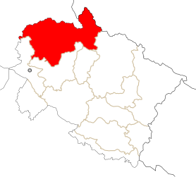
Uttarkashi (District)
| Uttarkashi District उत्तरकाशी जिला |
|
|---|---|

|
|
| State | Uttarakhand |
| Division : | Garhwal |
| Administrative headquarters : | Uttarkashi |
| Area : | 8016 km² |
| Residents : | 330,086 (2011) |
| Population density : | 41 people / km² |
| Website : | uttarkashi.nic.in |
The district of Uttarkashi ( Hindi : उत्तरकाशी जिला ) is a district of the Indian state of Uttarakhand .
The district administration is based in Uttarkashi . The district was established on February 24, 1960.
geography
The Uttarkashi District is located in the Garhwal Division in the north of Uttarakhand in the Garhwal Himalayas . Uttarkashi borders Himachal Pradesh in the north . In the northeast, the watershed of the main Himalayan ridge forms the border with the Tibet Autonomous Region . In the south the district borders on the following neighboring districts: Chamoli , Rudraprayag , Tehri Garhwal and Dehradun . The area of the Uttarkashi district is 8016 square kilometers. The area of the Uttarkashi district is in the catchment area of Bhagirathi , Yamuna and Rupin . To the west lies Govind National Park , east of the Gangotri National Park .
population
According to the 2011 census, the Uttarkashi district has 330,086 inhabitants.
Worth seeing
The Hindu pilgrimage sites of Yamunotri and Gangotri are located in the Uttarkashi district .
Web links
Individual evidence
- ^ Uttarkashi District website
- ↑ Census of India 2011: Primary Census Abstract - Uttarakhand. (PDF; 471 kB)
Coordinates: 30 ° 54 ' N , 78 ° 27' E

