Udham Singh Nagar
| Udham Singh Nagar District ऊधम सिंह नगर ज़िला |
|
|---|---|

|
|
| State | Uttarakhand |
| Division : | Kumaon |
| Administrative headquarters : | Rudrapur |
| Area : | 2542 km² |
| Residents : | 1,648,902 (2011) |
| Population density : | 649 inhabitants / km² |
| Website : | usnagar.nic.in/ |
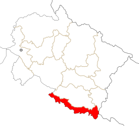
The district of Udham Singh Nagar ( Hindi : ऊधम सिंह नगर ज़िला ) is a district of the Indian state of Uttarakhand . District capital is Rudrapur . Udham Singh Nagar was detached from the Nainital district as an independent district in October 1995 .
geography
Udham Singh Nagar District is located in the Kumaon Division in the southeast of Uttarakhand. The district forms a 135 km long tube with an average width of 19 km, which lies entirely in the Ganges plain and only reaches the first mountain range of the Siwaliks in the extreme northeast . In the south the district borders on the state of Uttar Pradesh . In the north lies Nainital. In the extreme northeast, the district borders on Champawat and Nepal . The largest cities are Rudrapur with 154,485 inhabitants (as of 2011, urban agglomeration) and Kashipur with 121,610 inhabitants (as of 2011, urban area). The area of the Udham Singh Nagar district is 2542 km².
population
According to the 2011 census, the Udham Singh Nagar district has 1,648,902 inhabitants.
Administrative division
The district is divided into 8 tehsils :
- Bajpur
- Gadarpur
- Jaspur
- Kashipur
- Khatima
- Kichha
- Rudrapur
- Sitarganj
There are two Municipal Corporations ( Nagar Nigam ):
There are also 6 Nagar Palika Parishads in the district:
Nagar Panchayats in the district are:
Web links
Individual evidence
- ↑ Udham Singh Nagar District website
- ↑ Census of India 2011: Primary Census Abstract - Urban Agglomerations / Cities (PDF; 138 kB)
- ↑ Census of India 2011: Primary Census Abstract - Uttarakhand. (PDF; 471 kB)
- ↑ a b c d District administration of Nainital
Coordinates: 28 ° 58 ' N , 79 ° 39' E
