Almora (District)
| Almora District अल्मोड़ा जिला |
|
|---|---|

|
|
| State | Uttarakhand |
| Division : | Kumaon |
| Administrative headquarters : | Almora |
| Area : | 3144 km² |
| Residents : | 622,506 (2011) |
| Population density : | 198 inhabitants / km² |
| Website : | almora.nic.in |
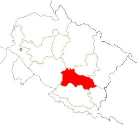
The Almora ( Hindi अल्मोड़ा जिला ) district is a district in the Indian state of Uttarakhand . The seat of the district administration is Almora .
geography
The Almora District is located in the Kumaon Himalayas in the Kumaon Division in the southeast of Uttarakhand. Neighboring districts are Pithoragarh , Bageshwar and Chamoli in the north, Pauri Garhwal in the west, Nainital in the south and Champawat in the southeast. The eastern part of the district is drained via the Sarju . The central part is traversed by the Kosi , a left tributary of the Ramganga . The Ramganga flows through the western part of Almora. The area of the Almora district is 3144 km².
population
According to the 2011 census, the Almora district has 622,506 inhabitants.
Web links
Individual evidence
Coordinates: 29 ° 42 ' N , 79 ° 32' E

