Alaknanda
| Alaknanda | ||
|
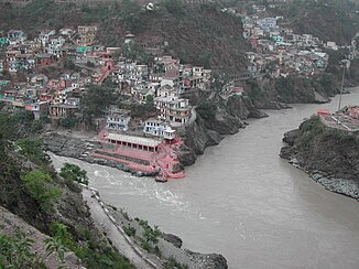
The Alaknanda (above) unites with the Bhagirathi (below left in the picture) at Devprayag |
||
| Data | ||
| location | Uttarakhand ( India ) | |
| River system | Ganges | |
| Drain over | Ganges → Indian Ocean | |
| Confluence of |
Satopanth Glacier and Bhagirath Kharak 30 ° 46 ′ 51 ″ N , 79 ° 25 ′ 11 ″ E |
|
| Source height | approx. 3750 m | |
| Union | with Bhagirathi at Devprayag on the Ganges Coordinates: 30 ° 8 ′ 42 ″ N , 78 ° 35 ′ 51 ″ E 30 ° 8 ′ 42 ″ N , 78 ° 35 ′ 51 ″ E |
|
| Mouth height | 475 m | |
| Height difference | approx. 3275 m | |
| Bottom slope | approx. 17 ‰ | |
| length | 190 km | |
| Catchment area | 10,882 km² | |
| Drain |
MQ |
439 m³ / s |
| Left tributaries | Saraswati , Dhauliganga , Nandakini , Pindar | |
| Right tributaries | Mandakini | |
| Medium-sized cities | Srinagar | |
| Small towns | Gauchar | |
The Alaknanda (or Alakananda ; Sanskrit: अळकनन्दा) forms the left source river of the Ganges .
It flows through the Himalayas in the Indian state of Uttarakhand in a predominantly southwestern direction. The other source river, the Bhagirathi , is the longer of the two.
River course
The Alaknanda arises at the confluence of the Satopanth Glacier and the Bhagirath Kharak Glacier in Uttarakhand. Shortly afterwards the Saraswati flows into the river from the left. It meets the Bhagirathi at Devprayag after 190 km . Main tributaries are Dhauliganga , Mandakini , Nandakini, and Pindar .
Web links
Commons : Alaknanda - collection of pictures, videos and audio files
