Keizersgracht
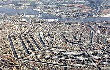
The Keizersgracht (German Kaisergraben ) is the middle of the three main canals of the Amsterdam canal belt that was created in the 17th century in the old town of Amsterdam . It encloses the medieval city center in a semicircle to the west and south. The Herengracht runs parallel to it inside , and the Prinsengracht outside it .
history
The Keizersgracht was laid out in 1612 on the initiative of Mayor Frans Hendricksz Oetgens van Waveren , city architect Hendrick Jacobsz Staets and city surveyor Lucas Jansz Sinck. It is the widest canal in the center of Amsterdam. The canal was named in honor of Emperor Maximilian I (HRR) .
The construction of the road and the moat began in the west of the old town. The southern part between Leidsegracht and Amstel was created in the course of an expansion in 1658. The youngest part is the continuation beyond the Amstel to the plantation , which was named Nieuwe Keizersgracht .
The Querido Verlag was located in Keizersgracht 333. From 1933, under the direction of Fritz Helmut Landshoff, it published the works of important German-speaking authors who were banned in Nazi Germany and thus played an important role in German exile literature.
Cross-section and course
The street consists of a wide navigable canal in the middle, which is limited on both sides by a drivable road to the development of the houses and spanned by a total of 14 bridges at the level of cross streets. As usual in Amsterdam's old town, the road embankments are now designated as one-way streets, so that the canal forms a broad median.
According to the typical old Dutch construction, the plots are usually very deep, but only have a narrow street front.
The Keizersgracht is 2.7 kilometers long and begins in the northwest of the old town on the Brouwersgracht and initially runs in a south-westerly direction. Shortly before crossing the Raadhuisstraat , at the Westerkerk , it makes a bend in a southerly direction. Further bends on the Leidsegracht , the Nieuwe Spiegelstraat and the Reguliersgracht direct the course in an easterly direction until the Keizersgracht in the south of the old town meets the natural river Amstel .
A little south of the confluence of the Keizersgracht, the Magere Brug leads over the Amstel.
Across the Amstel is the short Nieuwe Keizersgracht , which leads to the plantation and is crossed by two other bridges, including the Weesperstraat .
In the course of Raadhuisstraat, Leidsestraat , Vijzelstraat and Utrechtsestraat Keizersgracht of is trams crossed, are excluding the Vijzelstraat on the Keizersgracht stops. The Nieuwe Keizersgracht is crossed by the subway as part of the Weesperstraat , the next train station is one block further north on the Waterlooplein .
All sections of the canal belong to the Amsterdam-Centrum district .
Well-known structures
The street's numerous architectural monuments include
- Keizersgracht 102: De Rode Hoed (1630)
- Keizersgracht 123: the Huis met de hoofden (1622)
- Keizersgracht 177: de Coymanshuizen, designed by Jacob van Campen (1625)
- Keizersgracht 209: de Hoop (1734)
- Keizersgracht 220: the Church of Our Lady (1854)
- Keizersgracht 224: Saxenburg (1765)
- Keizersgracht 225: De Koopermoole (1746)
- Keizersgracht 324: Felix Meritis (1787)
- Keizersgracht 333: (1710) was the Querido publishing house .
- Keizersgracht 334–336: the Claes Reinierszhofje (1618)
- Keizersgracht 401: Huis Marseille (1665), today the Museum of Photography
- Keizersgracht 609: FOAM, Amsterdam Photography Museum , formerly Museum Fodor
- Keizersgracht 672–674: the Van Raey houses, now the Van Loon Museum (1671)
- Keizersgracht 676: the New Walloon Church (1856)
Many of the magnificent baroque canal houses in the Keizersgracht were built by the Amsterdam architects Philips Vingboons (1607–78) and Adriaan Dortsman (1635–82).
At the corner of the Raadhuisstraat are the Westerkerk (1620–31) and the world's first memorial against the persecution of homosexuals, the Homomonument (1987).
House numbers
The numbering of the houses on Keizersgracht starts at the northwest end of the street. The odd numbers are on the “inner” side of the street (facing the old town), the even numbers are on the outside.
- The Raadhuisstraat crosses at 200 and 183 Keizersgracht
- The Leidsestraat crosses at 508 and 455 Keizersgracht
- The Vijzelstraat crosses at Keizersgracht 648 and 589
- The Utrechtsestraat crosses at Keizersgracht 764 and 709
Known residents
Known residents of the street include:
- John Adams (1735–1826), Second President of the United States, Keizersgracht 529.
- Paul Biegel (1925–2006), Dutch children's author.
- Johann Rudolph Glauber (1604–1670), pharmacist and first industrial chemist, presumably Keizersgracht 109
- Mattheus Lestevenon (1715–1797), councilor and diplomat; Thomas Hope (1704–1779), Henry Hope (around 1735–1811) and Adriaan van der Hoop (1778–1854), art collectors and bankers, all in Keizersgracht 444–446, the former public library
- Han van Meegeren (1889–1947), painter and art forger, Keizersgracht 321
- Benno Premsela (1920–1997), architect and LGBT activist, Keizersgracht 518
- Nicolaes Tulp (1593–1674), Amsterdam mayor and surgeon
See also
- Canals in Amsterdam
- Nine streets , side streets of the Amsterdam canal belt
Individual evidence
- ↑ JA Wiersma, De naam van onze straat , Amsterdam 1987 ISBN 9062740243 blz. 118
- ↑ The house on Keizersgracht 333
Web links
- Amsterdamse grachtenhuizen Photos of canal houses on Keizersgracht (Dutch)
Coordinates: 52 ° 22 ′ 1 ″ N , 4 ° 53 ′ 5 ″ E


