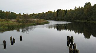
Kema (White Lake)
|
Kema Кема |
||
| Data | ||
| Water code | RU : 08010200312110000009138 | |
| location | Vologda Oblast ( Russia ) | |
| River system | Volga | |
| Drain over | Sheksna → Volga → Caspian Sea | |
| origin |
Kemskoye Lake 61 ° 4 ′ 13 ″ N , 37 ° 35 ′ 15 ″ E |
|
| Source height | 164 m | |
| muzzle |
Weißer See Coordinates: 60 ° 18 ′ 56 " N , 37 ° 11 ′ 47" E 60 ° 18 ′ 56 " N , 37 ° 11 ′ 47" E |
|
| Mouth height | 113 m | |
| Height difference | 51 m | |
| Bottom slope | 0.34 ‰ | |
| length | 150 km | |
| Catchment area | 4480 km² | |
| Drain |
MQ |
44.8 m³ / s |
| Left tributaries | Indomanka | |
| Right tributaries | Korba | |
|
Location of the Kema (Кема) in the catchment area of the Rybinsk Reservoir |
||
The Kema ( Russian Кема ) is a tributary of the White Lake in the Vologda Oblast in the European north of Russia .
It forms the outflow of the Kemskoye Lake , which is fed by the Soida . The Kema initially flows in a southerly direction. It takes the Korba tributaries from the right and Indomanka from the left. Later it turns west and finally reaches the northern end of the White Lake. The river length is 150 km. The catchment area covers 4480 km². The mean discharge is 44.8 m³ / s. The Kema is frozen between the beginning of November and the end of April.
Individual evidence
- ↑ a b Kema in the State Water Register of the Russian Federation (Russian)
- ↑ a b c d Article Kema in the Great Soviet Encyclopedia (BSE) , 3rd edition 1969–1978 (Russian)

