Khartaphu
| Khartaphu | |
|---|---|
|
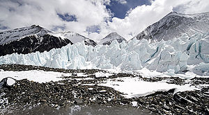
Eastern Rongpu Glacier in the foreground; Khartaphu is the mountain in the center of the picture in the background |
|
| height | 7227 m |
| location | Tibet ( China ) |
| Mountains | Mahalangur Himal ( Himalaya ) |
| Dominance | 7.4 km → Changtse |
| Notch height | 679 m ↓ Rapiu La (6548 m) |
| Coordinates | 28 ° 3 '48 " N , 86 ° 58' 37" E |
| First ascent | July 18, 1935 by Eric Shipton , Edwin Kempson and Charles Warren |
The Khartaphu (also Kharta Phu ) is a 7227 m (according to other sources 7213 m ) high mountain in the Himalayas in the district of Dingri of the Shigatse administrative district in the Tibet Autonomous Region of the People's Republic of China 9.85 km north-northeast of Mount Everest .
The 7045 m high Lhakpa Ri lies south of the Khartaphu. The northeast shoulder of Mount Everest rises further south . The Kartaphu has a secondary peak to the west, the 7018 m high Xiangdong ( ⊙ ).
Ascent history
The first ascent was made on July 18, 1935 by Eric Shipton , Edwin Kempson and Charles Warren as part of the British exploration expedition of 1935 . They climbed the summit from the Eastern Rongpu Glacier via its tribute glacier Sportmangletscher and the northwest ridge .
Web links
- Khartaphu on Peakbagger.com (English)
- Khartaphu at Peakware (English)
- Photos and information at astrocycloalpine.weebly.com
- Photo at himalaya-info.org

