Kilchiaran
|
Kilchiaran Scottish Gaelic Cill Chiarain |
||
|---|---|---|
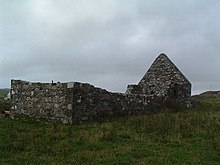
| Buildings in Kilcharian | ||
| Coordinates | 55 ° 45 ′ N , 6 ° 27 ′ W | |
|
|
||
| administration | ||
| Post town | ISLE OF ISLAY | |
| ZIP code section | PA46 | |
| prefix | 01496 | |
| Part of the country | Scotland | |
| Council area | Argyll and Bute | |
| British Parliament | Argyll and Bute | |
| Scottish Parliament | Argyll and Bute | |
Kilchiaran ( Gaelic : Cill Chiarain ) is a hamlet on the west coast of the Scottish Hebridean island of Islay . The village is located on the Rhinns of Islay peninsula a few hundred meters from a small bay in the Atlantic Ocean known as Kilchiaran Bay , into which a small stream flows through the settlement. Port Charlotte and Portnahaven , the most important settlements on the Rhinns of Islay, are four kilometers east and eight kilometers south, respectively.
Kilchiaran can be reached via a single-lane road that leads from Portnahaven along the west coast to Kilchiaran and from there runs east to Port Charlotte. In Kilchiaran are in the Georgian style built Kilchiaran Farmhouse , the associated stables and the medieval St. Ciaran's Chapel three listed buildings and groups of buildings.
The cup stone ( English Cup marked stone ) of Kilchiaran lies above the place, near the ruins of the St. Ciaran's Chapel . The 1.7 m × 0.98 m plate with a maximum thickness of 0.15 m has at least 19 bowls with a diameter of up to 110 mm and a depth of 40 mm.


