Kinburn Peninsula
| Kinburn | ||
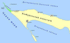
 Kinburn Peninsula map |
||
| Geographical location | ||
|
|
||
| Coordinates | 46 ° 31 ′ 0 ″ N , 31 ° 46 ′ 0 ″ E | |
| Waters 1 | Dnepr-Bug-Liman | |
| Waters 2 | Jahorlyzkyj Bay | |
| length | 40 km | |
| width | 10 km | |
| surface | ||
 Seagulls on the Kinburn Spit |
||
The Kinburn Peninsula ( Ukrainian Кінбурнський півострів ; Russian Кинбурнский полуостров ) is a peninsula in the south of Ukraine between the Jahorlyzkyj Bay of the Black Sea in the south and the Dnieper Bug Liman in the north .
geography
The peninsula is about 40 km long, up to 10 km wide and has an area of about 180 km². The Kinburn Spit is in the northwest of the peninsula . Opposite it is the coast of the Ukrainian mainland with the port city of Ochakiv . The strait between the coasts is the Kinburn Canal .
history
The peninsula got its name from the fortress Kinburn , built in the 16th century and now destroyed , a military installation built by the Ottomans to secure the Dnepr estuary. The name comes from the Turkish "Kilburun" and means something like "fine (narrow) headland". The fortress was often fought over between the Ottomans on the one hand and the Cossacks, and later the Russians on the other. In 1787 and 1855 battles over the fortress took place on the peninsula. "
Flora and fauna
The peninsula is home to more than 600 species of flora, many of which are endemic. The fauna includes 45 species of mammals, 30 species of birds, including many rare, 74 species of fish and around 4000 different species of insects. One of the natural wonders of the peninsula is the orchid field of Pokrovske , one of the largest orchid fields in Europe. Parts of the peninsula are under nature protection, the spit belongs to the Ukrainian national park Bilobereschja Svjatoslawa ( Білобережжя Святослава ).
Localities
The western part of the peninsula belongs administratively to the Ochakiv Raion of the Mykolaiv Oblast , the eastern part to the Hola Prystan Raion of the Kherson Oblast . The villages of Pokrovka , Vasylivka and Pokrovke are located in the Mykolaiv Oblast , and the village of Herojske in the Kherson Oblast .
Web links
Individual evidence
- ↑ a b Kinburn Peninsula in the Encyclopedia of Modern Ukraine , accessed July 26, 2015
- ↑ Kinburn Story on the Institute of History of Ukraine website , accessed July 26, 2015
- ↑ General Prosecutor's Office of Ukraine September 29, 2014 , accessed July 26, 2015
