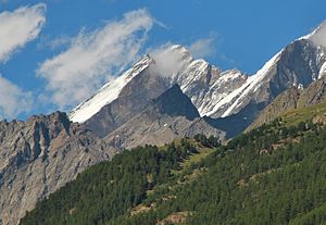
Kinhorn
| Kinhorn | ||
|---|---|---|
|
The Kinhorn (center) in front of the cathedral |
||
| height | 3750 m | |
| location | Switzerland | |
| Mountains | Valais Alps | |
| Dominance | 0.3 km → Taschhorn | |
| Notch height | 114 m ↓ Kinlücke | |
| Coordinates | 630 587 / 102929 | |
|
|
||
| Normal way | via Täschhütte / Kinhütte (WS) | |
The Kinhorn is 3750 m above sea level. M. high mountain in the Valais Alps in Switzerland .
location
The Kinhorn is located west of the Täschhorn on the soil of the municipalities of Randa and Täsch . The Kinhorn is part of a long and pronounced ridge that stretches from the summit of the Täschhorn first as the Teufelsgrat to the west to the Kinlücke (3636 m) and from there over the Kinhorn to Ladders (3407 m) to the Horn (3213 m) and separates the Täschalp in the south from the high valley of the Kingletscher in the north. Due to this morphology, the mountain is only slightly different from the surrounding terrain. The glacier of the same name is located on the north flank of the Kinhorn, the tongue of which extends up to approx. 3100 m, and the Weingarten glacier is located southeast of the summit .
reachability
Due to its existence as a secondary peak of the Mischabel and the fact that its flanks are characterized by brittle rock and rubble heaps, the Kinhorn is rarely climbed. It can be climbed as a not very difficult high-altitude tour without climbing the glacier from the privately operated Kinhütte (north) or from the Täschhütte (south). The pathless climbs do not exceed the I. level of difficulty .

