Kirchhatten
|
Kirchhatten
Hatten municipality
Coordinates: 53 ° 1 ′ 16 ″ N , 8 ° 20 ′ 56 ″ E
|
||
|---|---|---|
| Height : | 31 m above sea level NHN | |
| Residents : | 2681 (Jun. 30, 2016) | |
| Postal code : | 26209 | |
| Area code : | 04482 | |
|
Location of Kirchhatten in Lower Saxony |
||
Kirchhatten is the third largest district of the municipality of Hatten in the Lower Saxony district of Oldenburg and the seat of the municipality.
geography
The place is at the intersection of the state roads L871 and L872, as well as at an end point of the L888.
history
Hatten or Kirchhatten was first mentioned in 860 as "Hatho" . The name Kerkhatten appears for the first time in 1260 to distinguish it from places with the same name .
religion
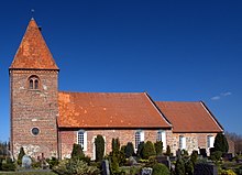
In the village is the seat of the parish of Hatten with the St. Ansgari Church , the construction of which is dated to the period from 1190 to 1195.
Personalities
Sons and daughters of the place
- Anton I of Aldenburg (1633–1680), imperial count and governor of the counties of Oldenburg and Delmenhorst
- Hermann von Wicht (1879–1942), Evangel. theologian
- Peter Suhrkamp (1891–1959), publisher
Individual evidence
- ↑ Facts & Figures. Population numbers by locality. Hatten municipality, accessed April 29, 2017 .
- ↑ Andreas Röpcke (ed.): Willehad: the life of St. Willehad, Bishop of Bremen, and the description of the miracles on his grave . S. 89 . see also miraculous healings at the grave of Bishop Willehad from Bremen
- ^ The St. Ansgari Church in Kirchhatten. Ev.-luth. Parish Hatten, accessed on April 29, 2017 .
- ↑ Ludwig Kohli: Handbook of a historical-statistical-geographical description of the Duchy of Oldenburg together with the inheritance of Jever, and the two principalities of Lübeck and Birkenfeld . Kaiser, 1825, p. 251 ( limited preview in Google Book search).


