
Kita-ku (Kyoto)
|
Municipality of Kyoto |
|
|---|---|
  |
|
| Coordinates | 35 ° 2 '28 " N , 135 ° 45' 15" E |
| surface | 94.92 km² |
| Residents | 117,933 (Oct 1, 2019) |
| Population density | 1242 inhabitants / km² |
| Start-up | Sep 1 1955 |
| Community key | 26101-7 |
Administration address |
33-1, Murasakino-Higashigoshodenchō, Kita-ku, Kyōto 603-8511 |
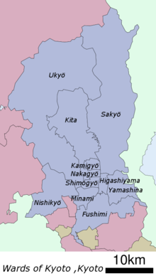
Kita-ku ( Japanese 北区 , German "northern district") is one of eleven districts ( ku ) of the Japanese city of Kyoto . It is located north of the historic city center and was created on September 1, 1955, when he was separated from Kamigyō-ku .

In Kita-ku are the Daitoku-ji (one of the main temples of the Rinzai school), the Kamo-shrine (one of the oldest shrines in Japan), the Imamiya-shrine with the Yasurai festival, the Kinkaku-ji (the golden pavilion , see picture) and Mount Funaoka-yama . In addition, the four universities of Bukkyō , Kyōto-Sangyō , Ritsumeikan and Ōtani have their headquarters in the district.
Web links
- official website (Japanese)
Fushimi-ku | Higashiyama-ku | Kamigyō-ku | Kita-ku | Minami-ku | Nakagyō-ku | Nishikyō-ku | Sakyō-ku | Shimogyō-ku | Ukyō-ku | Yamashina-ku