Kitaa
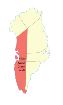
Kitaa / Vestgrønland (West Greenland) was one of the three administrative districts ( amt ) of Greenland until 2009 . Almost 90% of the entire population live in this area. The administrative seat was the Greenlandic capital , Nuuk .
To the west it was bordered by Baffin Bay , Davis Strait , Labrador Sea, and the North Atlantic . To the east was Tunu District and Avanersuaq District to the north .
All but three of the last 18 and originally 19 Greenlandic municipalities were in West Greenland. These originally 16 parishes in West Greenland were all established on November 18, 1950. These were, from south to north:
- Nanortalik municipality
- Qaqortoq municipality
- Narsaq parish
- Ivittuut municipality
- Paamiut parish
- Nuuk Parish
- Maniitsoq municipality
- Sisimiut municipality
- Kangaatsiaq municipality
- Aasiaat municipality
- Qasigiannguit parish
- Ilulissat municipality
- Qeqertarsuaq parish
- Vaigat municipality (incorporated in Qeqertarsuaq in 1972 because of relocation)
- Uummannaq parish
- Upernavik municipality
Effective January 1, 2009, the previous municipalities and districts were replaced by the four large municipalities Qeqqata Kommunia , Kommuneqarfik Sermersooq , Qaasuitsup Kommunia and Kommune Kujalleq as part of a comprehensive administrative reform .
