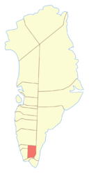
Narsaq district
| Narsap Communia Narsaq district
|
|
|---|---|
 |
|
| Basic data | |
| Country | Greenland |
| Commune | Kujalleq municipality |
| Seat | Narsaq |
| surface | 8500 km² |
| Residents | 1631 (January 1, 2018) |
| density | 0.2 inhabitants per km² |
Narsaq has been a district in western Greenland since 2009 .
location
The district of Narsaq is located in southern Greenland. It divides the Qaqortoq district into two parts and thus only borders on these in the coastal area.
history
Before the colonial era
The district was settled in the Middle Ages by the Grænlendingar , who built their Eystribyggð here. From the first settlers Einarr settled in Einarsfjǫrðr, which corresponds to today's Igalikup Kangerlua . The Brattahlíð farm and its church , located in what is now Qassiarsuk, was located in today's district. In Igaliku sooner the court Garðar, who was the bishop's seat of the medieval Greenland was.
South Greenland was approached several times by English and Dutch seafarers in the 16th and 17th centuries without their land sightings and names being precisely identifiable due to the inaccurate reports, mappings and dimensions.
18th and 19th centuries
The history of today's district begins in 1782, when Anders Olsen , who founded the Julianehaab colony in 1775, to which today's Narsaq district also belonged, settled in Igaliku when he was old and founded a farm.
Beyond that, however, the area was of little importance compared to the rest of the colonial district, probably because most of the district is so inland. It was not until 1883 that the first Udsted was founded in the district, Narsaq .
The majority of the population in today's Narsaq district used to belong to the Danish mission. The population was previously considered to be tall and not particularly Eskimo-looking, so it was theorized at the time that the population were descendants of Inuit and Grænlendingar. Hinrich Johannes Rink described a third of the population as looking European. The population in the colonial district, however, was considered to be very slightly ethnically mixed compared to the rest of Greenland. Even in 1921 it was still assumed that only ten to twelve percent of the population were of European descent, which can be traced back to the widespread presence of the Moravian Brethren in the southern part of the colonial district. Even today, the Kujataamiut are the weakest European population group in West Greenland (see Demography of Greenland ).
20th century
The colonial district of Julianehaab was divided into nine parishes from 1911, of which only the municipality of Nordprøven (Narssaĸ) was in the area of today's district. In 1918, four residential places were subordinate to this community. It belonged to the 5th district electoral council of South Greenland. Today's district belonged to the parish Julianehaab, which in 1918 had a school chapel in the Narsaq district. He was part of the Julianehaab medical district.
In 1933 Igaliku was founded as the second Udsted, and as a result, a second municipality was established in 1937.
In 1941 the United States established a military base in Narsarsuaq , which was taken over by Denmark in 1958. Since 1978 the village has served as the second largest airport in Greenland.
During the administrative reform in 1950, the colonial district was divided. One part became Qaqortoq Municipality , while the other parts formed Nanortalik Municipality and Narsaq Municipality. A third Udsted was founded a short time later with Qassiarsuk .
During the administrative reform in 2009, the municipality of Narsaq was incorporated into the municipality of Kujalleq and became a district.
places
In addition to the city of Narsaq , the following villages are located in the Narsaq district:
There are also the following shepherd settlements in the district:
- Arnannguit
- Attarnaatsoq
- Eqaluit Iluat
- Igaliku Kujalleq
- Inneruulalik
- Ipiutaq
- Issormiut
- Kangerlua
- Nunataaq
- Qinngua
- Qorlortoq
- Qorlortup Itinnera
- Sillisit
- Tasiusaq
- Timerliit
- Uummannartuuaraq
In addition, there are the following abandoned shepherd settlements:
In addition, the following abandoned settlements are in what is now the district area:
coat of arms
literature
- Jens Christian Madsen: Udsteder og bopladser i Grønland 1901-2000 . Atuagkat, 2009, ISBN 978-87-90133-76-4 .
- Ole Bendixen , Louis Bobé : Beskrivelse af Distrikterne i Sydgrønland: Julianehaab District . In: Georg Carl Amdrup , Louis Bobé , Adolf Severin Jensen , Hans Peder Steensby (eds.): Grønland i tohundredeaaret for Hans Egedes landing (= Meddelelser om Grønland . Volume 60-61 ). tape 2 . C. A. Reitzel Boghandel, Copenhagen 1921, p. 374–559 ( digitized in the Internet Archive ).
Coordinates: 60 ° 33 ′ N , 46 ° 0 ′ W