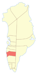
Maniitsoq District
| Maniitsup Communia Maniitsoq District
|
||
|---|---|---|
 |
||
| Symbols | ||
|
||
| Basic data | ||
| Country | Greenland | |
| Commune | Qeqqata communia | |
| Seat | Maniitsoq | |
| surface | 79,500 km² | |
| Residents | 3176 (January 1, 2019) | |
| density | 0 inhabitants per km² | |
Maniitsoq has been a district in western Greenland since 2009 .
location
The Maniitsoq District is located in central West Greenland. It is bordered to the north by the Sisimiut district and by the Nuuk district to the south .
history
Before the colonial era
The district area was approached by Dutch , English and Hamburg whalers in the 17th century . In 1691, the Danish King Christian V banned the Hanseatic cities from trading in Greenland, but withdrew the ban in the following year and instead demanded customs duties . After the Dutch were often violent towards the Greenlanders, the States General forbade this behavior in 1720. Instead, the English began robbing the Greenlanders and setting fire to their homes. In the 18th century, the residential areas Kangaamiut , Narsarmiut , Napasoq , Uummannaq, Saattormiut and Kangerluarsuk were more heavily inhabited.
In 1725 Hans Egede wanted to establish a colony on the Ammassivik fjord near Atammik , but a ship with material sank and a mosquito plague drove the people away, so that the district remained uncolonized for the time being.
18th century
In 1755 Anders Olsen founded the Sukkertoppen colony in Kangaamiut . In 1781 Sukkertoppen was moved to Maniitsoq because the place was supposedly well suited for whaling, which quickly turned out to be a mistake.
In the first few years Berthel Laersen was an important missionary in the colony and by 1775 he had already baptized 260 Greenlanders. In the 1780s, the last pagan Greenlander was converted to Christianity relatively early. Later the mission no longer played an important role in the history of the colonial district, because from 1792 it was part of the missionary office of the Holsteinsborg colony .
Around 1790 the Habakkuk movement emerged in the district , in which Habakkuk and his wife Maria Magdalena in Greenland pretended to be prophets and thus were able to gather almost the entire population of the area around them without the Danes succeeding in intervening. Only Frederik Berthelsen , Berthel Laersen's son, was able to break up the movement.
19th century
From around 1800 the colonial district of Maniitsoq was the most successful and the colony the largest in Greenland. In 1787 the colonial district had 298 inhabitants. In the 1820s there were 393, ten years later 504, another ten years later 662 inhabitants. By 1918 the population rose to 1158 people.
In 1833 Napasoq became a private trading post , which was nationalized in 1842 for exploiting the population. The residents hardly recovered and in 1856/57 a large part of the population died during a famine.
In 1877 the district area was enlarged somewhat by moving the Udsted Atammik from the colonial district of Godthaab to Sukkertoppen.
20th century
The residents of the colonial district were among the most genetically mixed in Greenland at the beginning of the 20th century. Many were so very European that they had blonde hair, blue eyes, and some even red hair, especially in Kangaamiut , Maniitsoq, and Napasoq .
At the beginning of the 20th century, the colony became the seat of a district doctor, who from 1914 was also responsible for the colonial district of Holsteinsborg.
From 1911 the colonial district of Sukkertoppen was divided into the four communities Kangâmiut , Sukkertoppen , Napassoĸ and Atangmik . In 1918 a total of seven residential spaces were subordinate to these communities. During the administrative reform in 1950, the colony district became the municipality of Maniitsoq. During the administrative reform in 2009, the municipality of Maniitsoq was incorporated into the Qeqqata Kommunia .
places
In addition to the city of Maniitsoq , the following villages are located in the Maniitsoq district:
In addition, the following abandoned settlements are in what is now the district area:
There are also some abandoned stations in the Ammassalik district:
coat of arms
Blazon : In blue, an inserted straight silver tip over which a reindeer head with antlers in confused colors lies.
literature
- Jens Christian Madsen: Udsteder og bopladser i Grønland 1901-2000 . Atuagkat, 2009, ISBN 978-87-90133-76-4 .
- Ole Bendixen , Louis Bobé : Beskrivelse af Distrikterne i Sydgrønland: Sukkertoppen District . In: Georg Carl Amdrup , Louis Bobé , Adolf Severin Jensen , Hans Peder Steensby (eds.): Grønland i tohundredeaaret for Hans Egedes landing (= Meddelelser om Grønland . Volume 60-61 ). tape 2 . C. A. Reitzel Boghandel, Copenhagen 1921, p. 95–175 ( digitized in the Internet Archive ).
Coordinates: 65 ° 18 ′ N , 51 ° 27 ′ W

