Kiteto (District)
| Kiteto District | |
|---|---|
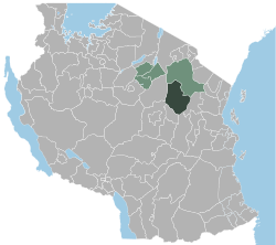
 Location of the Kiteto district in Tanzania |
|
| Basic data | |
| Country | Tanzania |
| region | Manyara |
| surface | 16,685 km² |
| Residents | 244,669 (2012) |
| density | 15 inhabitants per km² |
| ISO 3166-2 | TZ-26 |
Coordinates: 5 ° 52 ′ S , 36 ° 34 ′ E
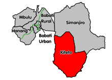
Kiteto is a district of the Manyara region in Tanzania with the administrative center in the city of Kibaya . The district borders in the north on the district Simanjiro , in the east on the Tanga region , in the south and west on the Dodoma region .
geography
Kiteto has an area of 16,685 square kilometers and around 250,000 inhabitants. The land lies between 1000 and 1500 meters above sea level on the Northern Plateau of Tanzania. The climate is a local steppe climate, BSh according to the effective climate classification . The annual amount of precipitation is low and lies between 500 and 650 millimeters. It rains mostly between December and April, from June to September it is very dry, so there are hardly any permanent rivers. The temperature is between 16 degrees Celsius in July and 21 degrees in December.
history
In 1974 the area came to the Arusha region and in 1993 it was divided into the two districts of Simanjiro and Kiteto. In 2002 Kiteto became a district of the newly established Manyara region.
Administrative division
The Kiteto district is divided into 19 parishes (wards) (as of 2012):
- Kibaya
- Partimbo
- Njoro
- Olboloti
- Makame
- Ndedo
- Kijungu
- Length file
- Sunya
- Dongo
- Song amble
- Dosidosi
- Engusero
- Matui
- Bwagamoyo
- Loolera
- Magungu
- Chapakazi
- Namelock
populationThe largest ethnic groups are the Maasai (32%), the Gogo (27%) and the Rangi (18%). The population rose from 152,296 in 2002 to 244,669 in the 2012 census. This corresponds to an annual growth of 4.7 percent or a doubling time of less than 15 years. Around half of the over-five-year-olds spoke Swahili, five percent spoke Swahili and English, and almost half were illiterate. Facilities and services |
 |
- Education: In the 2017/2018 school year, 722 teachers at 90 primary schools taught 51,000 students. Three of these schools were private schools. Of the 20 secondary schools, two were private and eighteen state-run. Almost 300 teachers were available for 5000 students.
- Health: The district has one hospital, three health centers and 28 pharmacies.
- Water: In 2018, 37 percent of the population received safe and clean water within 400 meters:
| Water source | number | functioning |
|---|---|---|
| Borehole | 84 | 58 |
| natural source | 6th | 6th |
| Rainwater | 80 | 75 |
Economy and InfrastructureIn 2012, 40,000 of the 50,000 households were engaged in arable farming and livestock.
|
 |
politics
A district council is elected every 5 years in the district. The current chairman is Lailumbe Mollel (as of 2020).
Attractions
- Suledo Forest: In 1993 the Tanzanian government declared the 167,400 hectare Suledo Forest a reserve. The aim was to curb the overexploitation of these miombo forests. In 2002 this project won the Equator Prize.
Others
- Kiteto is the bishopric of the Anglican Church .
- Partnership: The Anglican Church of Leicester has a partnership with the Diocese of Kiteto.
Web links
Individual evidence
- ^ A b Tanzania Regional Profiles, 21 Manyara Regional Profiles. (PDF) The United Republic of Tanzania, 2016, p. 15 , accessed on April 29, 2020 .
- ↑ Kibaya climate: Average Temperature, weather by month, Kibaya weather averages - Climate-Data.org. Retrieved April 29, 2020 .
- ^ Maps of the World. Russian Army Maps, S. Map 500k - xb37-1 , accessed April 29, 2020 (Russian).
- ↑ a b History | Kiteto District Council. Retrieved April 29, 2020 (Swahili).
- ↑ a b Five Years Strategic Plan 2016 / 17–2020 / 21. (PDF) The Kiteto District Council, June 2018, pp. 1–2 , accessed on April 29, 2020 .
- ↑ 2012 Population and Housing Census. (PDF) National Bureau of Statistics and Ministry of Finance, March 2013, p. 196 , accessed on April 29, 2020 .
- ↑ Tanzania Regional Profiles, 21 Manyara Regional Profiles. (PDF) The United Republic of Tanzania, 2016, p. 68 , accessed on April 29, 2020 .
- ↑ Five Years Strategic Plan 2016 / 17–2020 / 21. (PDF) The Kiteto District Council, June 2018, pp. 12-13 , accessed on April 29, 2020 .
- ↑ Five Years Strategic Plan 2016 / 17–2020 / 21. (PDF) The Kiteto District Council, June 2018, pp. 16-13 , accessed on April 29, 2020 .
- ↑ Five Years Strategic Plan 2016 / 17–2020 / 21. (PDF) The Kiteto District Council, June 2018, p. 21 , accessed on April 29, 2020 .
- ↑ Five Years Strategic Plan 2016 / 17–2020 / 21. (PDF) The Kiteto District Council, June 2018, pp. 27–28 , accessed on April 29, 2020 .
- ↑ Tanzania Regional Profiles, 21 Manyara Regional Profiles. (PDF) The United Republic of Tanzania, 2016, p. 118 , accessed on April 29, 2020 .
- ↑ Five Years Strategic Plan 2016 / 17–2020 / 21. (PDF) The Kiteto District Council, June 2018, pp. 29–30 , accessed on April 29, 2020 .
- ↑ Tanzania Regional Profiles, 21 Manyara Regional Profiles. (PDF) The United Republic of Tanzania, 2016, pp. 120, 123 , accessed on April 29, 2020 .
- ↑ Kiteto District, Manyara Region, Tanzania. Retrieved April 29, 2020 .
- ^ Tanzania Trunk Road Network. Retrieved April 29, 2020 .
- ↑ Five Years Strategic Plan 2016 / 17–2020 / 21. (PDF) The Kiteto District Council, June 2018, p. 32 , accessed on April 29, 2020 .
- ^ Siegfried Schröder and Elke Kuhne: Elections in Tanzania 2015. (PDF) Rosa Luxemburg Foundation, November 9, 2015, p. 3 , accessed on April 26, 2020 .
- ↑ Mwanzo | Home. Retrieved April 29, 2020 .
- ↑ Suledo Forest community. (PDF) United Nations Development Program, 2012, p. 3 , accessed April 29, 2020 .
- ^ Anglican Communion Office: Anglican Communion: Diocese. Retrieved April 29, 2020 .
- ^ Diocese of Leicester | Kiteto and Kilimanjaro. Retrieved April 29, 2020 .
