
Kitzloch Gorge

The Kitzlochklamm is a gorge of the Rauriser Ache , a right tributary of the Salzach , and represents the exit of the Rauris valley into the Salzach valley. It is located on the municipal boundary of Taxenbach (Pinzgau) and Lend (village of Embach ), in the state of Salzburg .
Landform
The gorge is about 1500 meters long, the difference in altitude is over 100 meters. The gorge runs from south to north and is protected as a natural monument. The gorge subsoil consists of slate . The Rauriser Ache first flows through the narrowest part of the gorge, at the actual Kitzloch , then the gorge widens and after another narrow point, into which a tributary flows as a waterfall , the valley opens towards Taxenbach, the river flows into the Salzach .
Development
A secured, easy path leads through the gorge, which can be climbed in the summer months for a fee. The entrance to the gorge is about 1000 meters (lower end of the gorge) south of Taxenbach, directly on the main road from Sankt Johann im Pongau to Zell am See . At the upper end of the gorge, after another half an hour's walk, you reach the road to Rauris . The climbing systems in the upper section were renewed in 2008, so that a complete ascent of the gorge is possible again. In the gorge there is also an old ore tunnel, an abandoned hermitage and a (inaccessible) stalactite cave along the way . On July 29, 1974, a bridge collapsed under the weight of a group of students, killing eight girls and injuring numerous students. The gorge was then closed for a few years. A memorial at the upper end of the gorge commemorates this tragic accident.
Two Austrian long-distance hiking trails lead through the Kitzlochklamm , the Zentralalpenweg 02 ( Hainburg an der Donau - Feldkirch ) and the Rupertiweg 10 ( Bohemian Forest - Carnic Alps ).
Views

The climbing system between the lower and the upper bottleneck
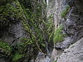
View into the upper bottleneck downstream from the footbridge over the gorge

View into the upper bottleneck upstream (in the background the footbridge over the gorge)
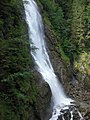
View of the waterfall in the upper narrow point from the footbridge over the gorge


literature
- K. Bistritschan, E. Braumüller: The geology of the tunnel Rauris - Kitzloch in the area of the north edge of the Tauern (Salzburg) . In: Communications from the Geological Society in Vienna . tape 49 . Vienna 1956, p. 85–106 ( uibk.ac.at [PDF] On the geology of the Kitzlochklamm).
Web links
Coordinates: 47 ° 17 ′ 10 ″ N , 12 ° 58 ′ 27 ″ E
