
Little Camargue

The Little Camargue , French: la Petite Camargue , is part of the southern French coastal plain, divided between the departments of Gard ( Occitanie region ) and Bouches-du-Rhône ( Provence-Alpes-Côte d'Azur region ).
Boundaries and neighborhoods
In the east, the Little Rhone (Petit Rhône) forms the border with the Camargue proper . In the north, the Little Camargue stretches across the Canal du Rhône à Sète to the foot of the Cevennes . The western boundary is the city of Aigues Mortes , through which the Vistre flows from the Cevennes to the Mediterranean, between it and the mouth in Le Grau-du-Roi separated by dams more from the water surface of the Étangs than from land.
The extension of the Little Camargue is about 200 km² without water areas, with water areas between 300 km² and 400 km².
landscape
The small Camargue is part of an alluvial plain , but after its formation, the further sediment input from the rivers that border it to the east and west was insufficient to fully compensate for the rise in sea level. In the plain between the mountain foot and the coastline marked by dunes, the extensive water areas of the numerous and often interconnected étangs have formed.
The agricultural land consists essentially of a strip extending in an east-west direction from Aigues-Mortes to the Little Rhone and a narrow strip between the north bank of the Canal du Rhône à Sète and the foot of the Cevennes. Ditch systems provide irrigation to counteract salinization and drainage.
Between the two agricultural zones in the north and in the middle, and between the latter and the dune band along the coast, there are extensive areas of water and swamp. At Aiges Mortes, salt is extracted from these areas. Otherwise there are large stocks of reed beds .

Saline near Aigues-Mortes

Étang de Scamandre at the foot of the Cévennes
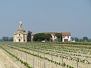
Viticulture and chapel in Gallician


Sources of information
- Larousse article on the Camargue:
- Current version - short version
- La G rande E ncyclopédie, Éd. 1971-1976, pages 2391 and 2392
- IGN France geoportal
Coordinates: 43 ° 34 ' N , 4 ° 17' E