
Knöpfelstaler pond
| Knöpfelstaler pond | ||
|---|---|---|

|
||
| The Knöpfelstaler pond | ||
| Geographical location | Thuringian Forest | |
| Data | ||
| Coordinates | 50 ° 38 '14 " N , 10 ° 53' 15" E | |
|
||
| Altitude above sea level | 598 m above sea level NN | |

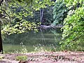
The Knöpfelstaler pond is located in the Thuringian Forest in the valley of the Schorte about 1.5 kilometers northeast of Stützerbach and about five kilometers southwest of Ilmenau in the Ilm district . It was originally created as a rafting pond . This is located in the nature reserve of the UNESCO biosphere reserve Vessertal and belongs to Zone II in the area " Marktal und Morast ".
The Knupfelstaler pond was first mentioned as a reservoir as early as 1587 . Reservoirs served as raft reservoirs - from here the logs from the surrounding forest were rafted into the Ilm valley and as far as Weimar . Today it is used as a rearing water for fish ( char ). The Knöpfelstaler pond is 598 m high and is on the Goethe hiking trail . From here you can continue up the valley to the uppermost part of the Schortetal to the Finsteren Loch - a densely wooded rock canyon with a small waterfall.
The Schortetal and its extensions up to the Rennsteig , the Breite Grund and the Marktal, once saw a brisk rafting operation. The Seifiger pond, the Breitengrund pond and the Knöpfelstaler pond still bear witness to this. The waters that feed these ponds combine below the Knöpfelstaler pond and form the Schorte. This is where the rafted wood came together to be transported further on the greatly increased water of this river.
The hike and shelter immediately adjacent to the pond was badly affected by hurricane Kyrill from January 18 to 19, 2007 from falling trees, so that it had to be torn down. A new one was built in the same place in 2008.

Goethe hiking trail at the Knöpfelstaler pond
The Knöpfelstaler pond

Knöpfelstaler pond hiking hut

The Knöpfelstaler pond


