
Konjatyn (Sosnytsya)
| Konjatyn | |||
| Конятин | |||

|
|
||
| Basic data | |||
|---|---|---|---|
| Oblast : | Chernihiv Oblast | ||
| Rajon : | Soznytsia district | ||
| Height : | 118 m | ||
| Area : | 2.16 km² | ||
| Residents : | 825 (2001) | ||
| Population density : | 382 inhabitants per km² | ||
| Postcodes : | 16140 | ||
| Area code : | +380 4655 | ||
| Geographic location : | 51 ° 36 ' N , 32 ° 47' E | ||
| KOATUU : | 7424984501 | ||
| Administrative structure : | 1 village | ||
| Address: | вул. Ювілейна буд. 23 16140 с. Конятин |
||
| Website : | City council website | ||
| Statistical information | |||
|
|||


Konjatyn ( Ukrainian Конятин ; Russian Конятин Konjatin ) is a village in the Ukrainian Oblast Chernihiv with about 800 inhabitants (2001).
Konjatyn has an area of 2.16 km² and is the only village in the district council of the same name in the east of Sosnytsia district .
The village is located at an altitude of 118 m on the right bank of the Desna , 27 km northeast of the Sosnytsia district center and 115 km east of the Chernihiv oblast center .
Territorial road T-25-16 runs north of the village .
Web links
Commons : Konjatyn - collection of images, videos and audio files
- Local history Konjatyn in the history of the cities and villages of the Ukrainian SSR (Ukrainian)
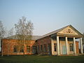
Clubhouse

Churches of the Ukrainian Orthodox Church

Street in Konjatyn
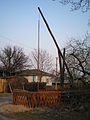
Age Ziehbrunnen
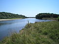
The Desna at Konjatyn


Individual evidence
- ↑ Local website on the official website of the Verkhovna Rada ; accessed on July 11, 2019 (Ukrainian)
- ^ Website of the district council on the official website of the Verkhovna Rada; accessed on July 11, 2019 (Ukrainian)
- ↑ РЕЛІГІЙНА ГРОМАДА УКРАЇНСЬКОЇ ПРАВОСЛАВНОЇ ЦЕРКВИ СВЯТО-УСПЕНСЬКОЇ ПАРАФІЇ С.КОНЯТИН СОСН40 С.КОНЯОГО РІОСН40. In: opendatabot.ua. Retrieved July 11, 2019 (among others).