
Desna (Dnepr)
|
Desna Десна |
||
 Desna catchment area |
||
| Data | ||
| location |
Sumy oblast , oblast Chernihiv , Kiev Oblast ( Ukraine ), Smolensk Oblast , Oblast Bryansk ( Russia ) |
|
| River system | Dnepr | |
| Drain over | Dnepr → Black Sea | |
| source |
Smolensk Heights 54 ° 35 ′ 38 ″ N , 33 ° 17 ′ 55 ″ E |
|
| muzzle | near Kiev in the Dnepr coordinates: 50 ° 33 ′ 3 ″ N , 30 ° 32 ′ 14 ″ E 50 ° 33 ′ 3 ″ N , 30 ° 32 ′ 14 ″ E
|
|
| length | 1130 km | |
| Catchment area | 88,900 km² | |
| Drain |
MQ |
360 m³ / s |
| Left tributaries | Bolwa , Nerussa , Seim , Oster , Shostka | |
| Right tributaries | Snow , south east | |
| Big cities | Bryansk , Chernihiv , Kiev | |
| Navigable | 535 km | |
The Desna ( Russian and Ukrainian Десна ) is a 1,130 km long left tributary of the Dnepr in the western or European part of Russia and in Ukraine .
River course
It rises in the Russian Oblast of Smolensk in the Smolensk Heights . There their source is east-southeast of Smolensk and not far from Jelnja in a forest near the village of Naleti . The Desna flows in a southerly direction to Bryansk after the Southeast coming from the north joins. After crossing the border with Ukraine, the Seim flows towards it from the east, after which it reaches Chernihiv . Further south, the Desna flows into the Dnepr just north of the Ukrainian capital Kiev .
The navigable length of the Desna is 535 km.
Surname
The name of the river Desna means "right hand" although it is a left tributary of the Dnieper. Presumably the Slavic tribes immigrated to this region from the south and accordingly found the river to the right of the Dnieper.
Tributaries and places
- The largest tributaries of the Desna are the Bolwa , Seim , Snow and Sudost
- On the Desna are the cities of Bryansk and Chernihiv , among others

Desna at Jelnja
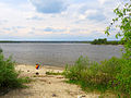
Desna run in the Mesinsky National Park near Ponornytsia

Desna near Chernihiv
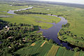
Muzzle into the Dnepr dammed up to the Kiev Sea


See also
- Timonowka a Upper Paleolithic storage site in the Bryansk Oblast
- List of the longest rivers on earth
Web links
Individual evidence
- ↑ a b c Article Desna (Dnepr) in the Great Soviet Encyclopedia (BSE) , 3rd edition 1969–1978 (Russian)