
Kopacz (mountain)
| Kopacz | ||
|---|---|---|
.jpg) View of the Kopacz mountain from the air of Sanok |
||
| height | 535 m | |
| location | Poland | |
| Mountains | Forest Carpathians | |
| Coordinates | 49 ° 34 ′ 0 ″ N , 22 ° 14 ′ 0 ″ E | |
|
||

The Kopacz (German Hauher , pl. Kopacz or Bana Gura , Rudowa Gura ) is an approximately 15 km² large and a maximum of 535 m npm high mountain range in the northern part of the Saana Mountains, as a prominent landmark on the Sanok lowland, in the extreme southeast of the country in the powiat Sanocki the Subcarpathian Voivodeship , in southeastern Poland . The range of hills lies in the ridge of the Middle Beskids at the narrowest point of the Santales (so-called Międzybrodzie rift ), where the Sanok Depression ends in the north. It is the southernmost branch of the Dynowskie foothills on the border of the Słonne Mountains (or the Sanok Salt Mountains ) and the Sanoker Depression. Its main peaks are Kopacz and Horodna 480 m npm

Kopacz (here Bana gu. ) On the old map of Galicia (1877)
_Bana_Gora,_Miedzybrodzie_am_San.JPG)
In the vicinity of the site there are mountain peaks 300–500 m above sea level, rich salt deposits and numerous salt springs in this area, which were still exploited at the end of the 19th century.
The earth here consists of dense red clay and lots of pebbles, it contains lots of minerals like iron or manganese .
In the immediate vicinity of the relics there are two neighboring castle walls, Horodyszcze and Horodne , as well as a burial mound in Trepcza not far from it. The high plateau shows traces of continuous settlement that stretched from the Bronze Age to the late Middle Ages . The find from Trepcza Square represents a further point within the small enclave of Celtic settlement, as it could be located in the eastern area of its distribution.
See also
gallery

Horodyszcze - Kopacz. Presentation of current research results (2014) 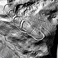
Ground plan of the Horodna am San castle wall (2013). Most of the historic old town of Sanok. In 1295 it was completely destroyed by the Tatars. 
Horodna - Kopacz Current research results from Jerzy Ginalski 
A gold stater of the Nike type from 336–323 BC. BC, which was found during excavations on the Kopacz mountain.


Web links
Footnotes
- ↑ 2. Military admission (1806–1869)
- ↑ First military admission (1769–1787)
- ↑ Folia botanica. edit. 9-12 1981
- ↑ Jerzy Kostrowicki. Środowisko geograficzne Polski. PWN. 1961
- ↑ Kwartalnik geologiczny. B. 22, 1978
- ^ The early days of Eastern Central Europe: the Polish-Ukrainian border area from an archaeological perspective. Instytut Archeologii Uniwersytetu Rzeszowskiego, Rzeszów, 2007. pp. 132-136 OCLC 233502973