
Międzybrodzie
| Międzybrodzie | |||
|---|---|---|---|

|
|
||
| Basic data | |||
| State : | Poland | ||
| Voivodeship : | Subcarpathian | ||
| Powiat : | Sanok | ||
| Geographic location : | 49 ° 36 ' N , 22 ° 11' E | ||
| Residents : | 130 | ||
| Postal code : | 38-503 | ||
| Telephone code : | (+48) 13 | ||
| License plate : | RSA | ||
| Economy and Transport | |||
| Street : | Międzybrodzka | ||
| Next international airport : | Rzeszów-Jasionka | ||

_Miedzybrodzie_am_San.JPG)
Międzybrodzie is a village in the rural municipality of Sanok in the Sanocki powiat in Poland .
geography
The village is located on the banks of the Saan River in the Carpathian Forest , surrounded by the Salt Mountains and the Hauher , a popular destination for excursions.
It is located three kilometers northwest of the township of Sanok in a hilly, wooded area ( Selpy Forest ). The place is at 300 to 450 m above sea level. M. and today is rather known as a place of pilgrimage.
Another settlement is Mrzygłód am San with a river crossing between Tyrawa Solna and Tyrawa Wołoska, Dobra and the historical settlement Ulucz.
The road to Sanok runs south of the village square near Międzybrodzie.
history
The place mentioned in a document around 1439 was called Miezebrodz in 1787 . The name refers to a place between [między] the fords [brody] . In 1510 an Orthodox church was built. For a long time, mostly Ukrainians lived here , who were resettled after the Second World War as part of the Vistula campaign .
Traces of settlement by residents from the 4th and 5th centuries have been discovered near the village .
One kilometer south of Miedzybrodzie lies on the left high bank, on the other side of the river Saan in a wooded range of hills, a settlement cluster from the 17th century BC, unique for the Carpathian region. BC to 8th century with numerous archaeological remains of the early medieval castle wall and monastery. The archaeological remains tell of people from the Bronze Age , the Latène Age and the Slavic culture. It is about two adjoining castle walls, Horodyszcze and Horodna , as well as a barrow field from the 8th / 9th centuries located nearby. Century in Trepcza.
The location of the village - in the Middle Ages - was strategically located at the crossroads between Salt Road from Tyrawa and the historic ford of the Carpathian path located on the San. The role and functions of the miedzybroden ford by the flow were as in 1852 shortly after the opening of bergischen path in Saltzgebirge according tyrawa wołoska (dt. Valachisch Thirau ) and Przemyśl changed.
Personalities
- Wolodymyr Kulczycki (1862–1936) Professor of Zoology at the University of Veterinary Medicine in Lwów
- Jerzy Kulczycki Junior (1898–1974) Professor of Prehistory and Protohistory in Kraków and Lwów
- Irina Dobrianska (1892–1982) Ukrainian archaeologist and folklorist, research assistant to Prof. Werner Radig
- Teodosius Starak (1931–1999) Ukrainian diplomat and Chargé d'affaires of Ukraine in Poland
- Władysław Mleczko - a Polish publisher
- Jerzy Ginalski - Polish archaeologist and folklorist
Culture and sights
- Trinity Church in Miedzybrodzie (1901)
tourism
Through the region leads:
-
 Hiking trail in the Beskid Subcarpathian region from Holzkirchen via Sanok to the village church of Bączal Dolny and on to Międzybrodzie - Mrzygłód - Ulucz - Dobra - Hołuczków back to Sanok.
gallery

Horodna on the San, as seen from Miedzybrodzie (2014)
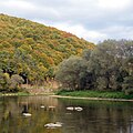
Miedzybrodzie near Horodna on the San (2014)

Gravestone of Professor Kulczycki in Miedzybrodzie

The holy house at the intersection of Dorfstrasse in Miedzybrodzie


See also
Web links
Footnotes
- ↑ Adam Carnival. Sanok: materiały do dziejów miasta do XVII w. 1990.
- ↑ First military recording (-1787)
- ↑ Acta militaria mediaevalia - T. 1. p. 66, 2005
- ↑ "niebieski"