
Sanok (rural community)
| Gmina Sanok | |||
|---|---|---|---|

|
|
||
| Basic data | |||
| State : | Poland | ||
| Voivodeship : | Subcarpathian | ||
| Powiat : | Sanocki | ||
| Geographic location : | 49 ° 33 ' N , 22 ° 12' E | ||
| Residents : | see Gmina | ||
| Postal code : | 38-500 | ||
| Telephone code : | (+48) 13 | ||
| License plate : | RSA | ||
| Gmina | |||
| Gminatype: | Rural community | ||
| Gmina structure: | 31 school authorities | ||
| Surface: | 231.38 km² | ||
| Residents: | 18,053 (June 30, 2019) |
||
| Population density : | 78 inhabitants / km² | ||
| Community number ( GUS ): | 1817052 | ||
| administration | |||
| Mayor : | Anna Hałas | ||
| Address: | ul.Kosciuszki 23 38-500 Sanok |
||
| Website : | www.gminasanok.pl | ||

The Gmina Sanok (German: Municipality Sanok ) is a rural municipality ( gmina wiejska ) in Powiat Sanocki , in the Subcarpathian Voivodeship , Poland . The municipality seat is the city of Sanok . It belongs to the historic Rothreußen region . Gmina Sanok is a member of the Carpathian Euroregion .
geography
After the first partition of Poland from 1772 to 1918, the area around the eastern Polish city of Sanok belonged to the Sanok district in the Austrian province of Galicia . It was located in the extreme southeast of Poland on the rivers San , Pielnica , Osława and Wisłok in the pre-Carpathian hill country or Sanok lowlands or Sanoker lowlands, the eastern part of the Gmina, surrounded by the salt mountains and the Lower Beskids . The highest point is the Słonny ( salty ) at 668 meters . Before World War II, the rivers became ethnic borders when the wild border area between Poland and Lemken was established.
The municipality has an area of 231 km². 54% of the municipal area is used for agriculture, 31% is covered with forest.
tourism
In the municipality there are some medieval village churches, of which the Gothic parish church of Mrzygłód , around 1410-2020, stands out. The Ukrainian Orthodox Church in Czerteż, Jurowce, Łodzina, Hłomcza, Ulucz and Dobra are part of a scenic cultural path ( Zdzisław Beksiński "Path of Remembrance") that goes around the town of Sanok due to their historical frescoes . The city's greatest attraction are two above-average museums, the Museum of Folk Architecture and the Castle . In their collections they contain a part of the rich local culture that developed in this area over many centuries in the process of mutual interpenetration of two civilization formations of the Orthodox East and Latin West.
The 45-kilometer voivodeship road No. 892 from Zagórz to Medzilaborce in eastern Slovakia - Andy Warhol's birthplace - leads through Sanok and there are designated hiking trails with a total length of 50 km.
-
 The cycle and long-distance hiking trail "In the footsteps of Schwejk" begins in the Czech Republic and continues to Austria, Hungary, Slovakia, Poland / Sanok to Ukraine.
 -
 Sanok - Biała Góra - Orli Kamień / Adlerfels 517 m - Słonna / Salzig 639 m - Przysłup - Rakowa - Chwaniów to Przemyśl
-
 Sanok - Orli Kamień / Aldlerfels 517 m back to Sanok
 -
 Hiking trail in the Beskid Subcarpathian region from Holzkirchen via Sanok and on to Międzybrodzie - Mrzygłód - Dobra - back to Sanok.
 -
 Sanok - Załuż - Przysłup 658 m back to Sanok
 -
 Sanok - the educational trail in the nature reserve of Polanki (salt mountains)
Borough
The city of Sanok forms an independent municipality (gmina miejska) .
Rural community
The rural community ( gmina wiejska ) Sanok has an area of 231.38 km². The following 31 localities with a Schulzenamt belong to it :
- Bykowce
- Czerteż
- Dębna
- Dobra
- Falejówka
- Hłomcza
- Jędruszkowce
- Jurowce
- Kostarowce
- Lalin
- Liszna
- Łodzina
- Markowce
- Międzybrodzie
- Mrzygłód
- Niebieszczany
- Pakoszówka
- Pisarowce
- Płowce
- Prusiek
- Raczkowa
- Sanoczek
- Srogów Dolny
- Srogów Górny
- Strachocina
- Stróże Małe
- Stróże Wielkie
- Trepcza
- Tyrawa Solna
- Wujskie
- Zabłotce
- Załuż
Larger places are Mrzygłód and Dobra in the north, Czerteż and Kostarowce in the west and Niebieszczany in the south. The smallest place is Międzybrodzie .
Other localities in the rural municipality are Zarszyn, Bukowsko and Zagórz.

Christmas
fair in Gmina Sanok Oberland Band Kapelle Kamraty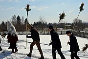
Young Trachtler
with traditional palm bushes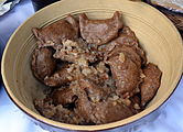
Lalin dumplings. The egg
noodle dough consists of wholemeal flour and water with a curled edge.
Easter cake,
Sanoczek at Sanok


Web links
Footnotes
- ↑ population. Size and Structure by Territorial Division. As of June 30, 2019. Główny Urząd Statystyczny (GUS) (PDF files; 0.99 MiB), accessed December 24, 2019 .
- ↑ regioset.pl (pl / en)
- ↑ "czerwony"
- ↑ "żółty"
- ↑ "niebieski"
- ↑ "Zielony"
- ↑ Ścieżka dydaktyczno-przyrodnicza "POLANKI" ( Memento of the original from March 4, 2016 in the Internet Archive ) Info: The archive link has been inserted automatically and has not yet been checked. Please check the original and archive link according to the instructions and then remove this notice.