Kotten (Winterswijk)
| province |
|
| local community |
|
|
Area - land - water |
11.33 km 2 11.33 km 2 0 km 2 |
| Residents | 665 (Jan. 1, 2017) |
| Coordinates | 51 ° 57 ' N , 6 ° 46' E |
| Important traffic route |
|
| prefix | 0543 |
| Postcodes | 7107-7108, 7115 |
| Website | Homepage of Kotten |
| Location of Kotten in the municipality of Winterswijk | |
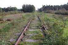
Kotten is a district of the Dutch municipality Winterswijk in the Achterhoek in the province of Gelderland near the German border. It is located in the triangle Winterswijk, Oeding (municipality of Südlohn ) and Burlo (city of Borken ). The rural scattered settlement , which has no real town center, has an area of 11.33 km² and has a good 665 inhabitants (as of January 1, 2017). The Winterswijk – Gelsenkirchen-Bismarck railway , which is now closed and partially dismantled on the Dutch section, ran through Kotten .
Web links
Commons : Kotten - collection of images, videos and audio files
- Place website (Dutch)
Individual evidence
- ↑ a b Kerncijfers wijken en buurten 2017 Centraal Bureau voor de Statistiek , accessed on July 24, 2018 (Dutch)


