
South wage
| coat of arms | Germany map | |
|---|---|---|

|
Coordinates: 51 ° 57 ' N , 6 ° 52' E |
|
| Basic data | ||
| State : | North Rhine-Westphalia | |
| Administrative region : | Muenster | |
| Circle : | Bark | |
| Height : | 54 m above sea level NHN | |
| Area : | 45.56 km 2 | |
| Residents: | 9262 (Dec. 31, 2019) | |
| Population density : | 203 inhabitants per km 2 | |
| Postcodes : | 46354, 46350 | |
| Area code : | 02862 | |
| License plate : | BOR, AH, BOH | |
| Community key : | 05 5 54 060 | |
| LOCODE : | DE SDL | |
| Address of the municipal administration: |
Winterswyker Str. 1 46354 Südlohn |
|
| Website : | ||
| Mayor : | Christian Vedder ( CDU ) | |
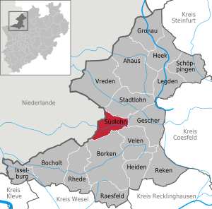
| Location of the community Südlohn in the Borken district | ||
  |
||


The community Südlohn ( Low German Söddloon ) is located in the western Münsterland in the northwest of the state of North Rhine-Westphalia and is a municipality in the district of Borken in the administrative district of Münster . In 2006 the parish Südlohn celebrated its 775th anniversary together with the Catholic parish of St. Vitus (today: St. Vitus and St. Jakobus ). The town hall is located in the district of Oeding .
geography
The municipality of Südlohn is on the border with the Netherlands . Entry into the neighboring country to the west is possible via the Oeding border crossing. In connection with the Schengen Agreement, there are hardly any controls here. Neighboring municipalities on the German side are Stadtlohn in the north, Gescher in the east, Velen in the south- east and Borken in the south . On the Dutch side, Südlohn borders on Winterswijk .
Südlohn consists of the districts Südlohn and Oeding.
- Südlohn to include the peasantry Brink, Esch wage, Horst, Trimbach, Tünte, Venn and Wienkamp.
- The farmers Ebbinghook, Feld, Fresenhorst, Hessinghook, Hinterm Busch, Look, Pingelerhook and Sickinghook belong to Oeding.
The loop , which rises just a few kilometers east in the area of Gescher, flows through the municipality from east to west . On its further course through the Achterhoek in Gelderland , it is initially called Boven-Slinge . The lower course is called Bielheimerbeek , which flows into the Issel at Doetinchem .
history
Since the early days
As a result of the division of the old parish of Lohn into the parts of Nordlohn, today's Stadtlohn, and Südlohn, the St. Vitus Chapel , which had been in existence since the 12th century, was elevated to an independent parish church in 1231. This created the basis for the formation of an independent settlement.
Due to the Spanish-Dutch war (1568-1648), which also had an impact on the regions near the border, Südlohn received in 1597 the right to fortify the place with ramparts and moats from the Bishop of Munster . With the granting of market rights on April 11, 1617, the place was considered a Wigbold or small town.
The urban development process was completed with the introduction of a city seal , which was first mentioned in 1761. The seal picture shows a three-leaf clover with the inscription "Sigil des Wigbohlt Sutlohn". The background for the choice of this seal image is unknown. Today the picture is interpreted as a shamrock, but it can also represent something else. The old seal was used until around 1840.
The district of Oeding goes back to the Nonern farmers with the main Oeding farm, which was first mentioned in documents in 1170 in the south-west of what was then the parish of Lohn. This main courtyard, on which there was already a castle, was sold in 1353 to the Münster bishop, who gave it to the Lords of Gemen as a fief until it was sold in 1554 . From 1372 they rebuilt the castle and a small settlement that had previously been captured as a result of a dispute with rebellious knights, which was legally subordinate to the lord of the castle. In the course of time, a castle freedom was formed , the origin of the Oeding settlement.
In the course of the Congress of Vienna in 1815, after centuries of rule by the Duchy of Münster , the community of Südlohn was added to the Kingdom of Prussia . Until 1883, the place Südlohn together with the farmers Eschlohn and Nichtern and the patch Oeding formed the independent office Südlohn. After that, the Südlohn office was incorporated into the Stadtlohn office. In 1907, the municipality of Südlohn ceded areas to the new municipality of Oeding.
At the turn of the 20th century in both districts, previously almost exclusively agriculturally dominated and in which only small craft that were home to industrialization arrived. Textile production and processing companies also settled in the area of today's municipality, and have shaped life in the municipality for decades.
Territorial reform
After the two municipalities Südlohn and Oeding , which had previously been official, agreed on a merger as part of the territorial reform , the new municipality Südlohn was formed by law on July 1, 1969. The new coat of arms, consisting of the cloverleaf for Südlohn and the castle tower for Oeding, was designed in collaboration with the Münster State Archives and a heraldist.
politics
Municipal council
2014–2019 parliamentary term
mayor
- Mayor Christian Vedder (CDU) was re-elected in May 2014 with 74.6 percent of the vote.
Coat of arms, banner and flag
With a certificate dated January 15, 1971, the district president Schneeberger granted the new community Südlohn the right to use a coat of arms, an official seal, a banner and a flag.

coat of arms

banner

flag

Coat of arms of the former municipality of Oeding

Coat of arms of the community of Südlohn 1964 - 1971


coat of arms
The official description of the coat of arms ( blazon ) of the current municipal coat of arms reads: “From silver (white) to red obliquely divided. Above is an upright three-leaf clover; below a silver (white) tower with a conical roof growing out of the edge of the shield and an upper storey projecting over a crenellated frieze. Of the six black windows, four are arranged in pairs above the frieze, two in stakes (heraldic) on the right below. “The coat of arms is a combination of the earlier municipal coats of arms of Südlohn (clover leaf; comes from a seal of the from 1761) and Oeding (castle tower of the castle Oeding).
Banner and flag
Description of the banner: “The municipality carries a banner with the municipality's coat of arms. The banner is striped lengthways in three strips in a ratio of 1: 3: 1 from red to white to red and shows the municipal coat of arms in the middle of the upper half of the white strip. "
Description of the flag: “The municipality has a hoisted flag with the municipality's coat of arms. The hoisted flag is striped lengthways in three strips in a ratio of 1: 3: 1 from red to white to red (meaning is cross-striped) and shows the municipal coat of arms in the shield in the middle of the white strip. "
Culture and sights

Menke tower windmill in Südlohn
The Menke tower windmill was built in 1812 as an octagonal building based on the Dutch model. Together with the neighboring miller's house, it forms an important ensemble of a village mill. Inside, the machines and equipment from the time of early industrialization are still completely present. An old saw frame is also still in use. The mill has been owned by the Menke family since 1865. Interior inspection by appointment, also on " Mühlentag " every Whit Monday.
Manor House Lohn in Südlohn
The former headquarters of a branch of the von Lohn dynasty is on the Schlinge. The manor house, which was still partially fenced, was rebuilt in 1795 after a fire. It is the only early classical aristocratic residence in the Borken district.
St. Vitus Church in Südlohn
The late Gothic hall church of St. Vitus in the Münsterland type was built in 1507 (north portal), but its core is much older. Presumably, the church was created from a chapel when it was raised to an independent parish in 1231. In 1936 the church was extended over a yoke according to plans by the architect Ernst Kreytenberg . The late Romanesque tower was demolished and replaced by a new one.
The precious interior with remains of the Baroque furnishings and especially the late Gothic ceiling frescoes (around 1510) with figurative representations and tendril decorations, which were only rediscovered in 1961, are worth seeing. They are the largest in the Münsterland.
Castle tower in Oeding


The squire Johann von Bermentvelde (Barnsfeld, Berntvelde) sold his main farm Oeding in the parish of Südlohn with mill, castle, buildings, fish ponds and accessories for 400 Marks to Bishop Ludwig II of Münster on April 18, 1353 . This was the first time that the existence of Oeding Castle and the village of Oeding ("Flecken Oeding in the non-farmers") was documented. Johann von Bermentvelde was immediately enfeoffed with the castle again and in 1365 received the castle and the main courtyard back in Oeding.
The "Haus Oeding" was rebuilt by Johann von Gemen immediately after Bishop Florence von Munster had the castle destroyed and razed in 1372 . Gemen redesigned the former earth hill castle as a rectangular ring-mantle castle according to the fort type, built a main castle with an outer bailey and allowed the freedom of the castle to be settled. This laid the foundation for the development of Oeding. In the course of history the castle changed hands frequently. After the sale to the Lords of Bermentfelde, the house came to Ambrosius von Viermünden (1517–1580), married to Friderune von Morrien (dated 1536–1556). He was enfeoffed with Oeding in 1536 and bought the hereditary claim to Oeding in 1555. His father Philipp von Viermünden zu Medebach and Nordenbeck († 1528) was enfeoffed in 1519 with the Münster “havezathe” Mallem near Eibergen / NL. Later ownership passed to the von Keppel family and finally to the von Mulert family. In 1839 the castle and the estates were sold and the moats filled in in 1854. The buildings were later torn down except for the castle tower and parts of the vault.
The tower from the second half of the 15th century and the still-preserved castle vault are the last remnants of the former Oeding Castle, which dates back to 1371/72. At that time, a patch was created near the castle Oeding, which emerged from a main courtyard . This is the most important historical place in the district of Oeding. The round brick tower from the second half of the 15th century has been preserved from the original moated castle, designed as a U-shaped system. Above a pointed arch frieze there is a twelve-sided top floor with gun ports, loopholes and a tent roof. The tower has been restored several times, most recently in 1979, and is now integrated into a new hotel building (since 1979).
St. Jakobus Church in Oeding
The Roman Catholic parish church of St. Jakobus was built in 1910–1911 based on a design by the Berlin architect Heinrich Jennen (1872–1920). In its architectural design, Romanesque and Baroque elements combine to form a neo-Romanesque , late historicist style. The colored glazing, which was designed by the painter Heinrich Nüttgens according to the Nazarene conception of art, shows the influence of Art Nouveau in its geometrical-ornamental parts . Parts of the baroque furnishings of the previous church on the Burgring were taken over into the new building. The high altar, created in 1915, corresponds through its medallions with the arched windows of the main entrance.
Evangelical Johannes Church in Oeding

By the middle of the 17th century at the latest, several Protestant Christians lived in Südlohn and Oeding. With the beginning of Prussian rule in 1815, the number of Protestants was increased by administrative staff and border officials. In this area of the Münsterland, however, there were only Protestant parishes in Werth and Bocholt. As the distances were great and the roads poor, the need for a community of their own grew. This was in 1823 by King Friedrich Wilhelm III. approved by Prussia and founded the Evangelical Church Community Oeding, to which Burlo , Südlohn and Weseke still belong today .
On Boxing Day 1822, a Protestant service was celebrated in Oeding for the first time. This was held in the old farm building of the Haus Oeding estate, which was owned by Baron von Mulert zu Nymwegen . In 1823 von Mulert donated the part of the building that contained the prayer room to the parish.
After the old building was demolished in 1824, the parish, with the active support of Frh. Mulert the now existing Evangelical Chapel. The foundation stone was laid on May 8, 1824. The church was inaugurated on August 11, 1825. It is a small classical hall building and is influenced by the Netherlands. The simple contemporary furnishings were retained. In 1984 the church was included in the list of monuments of the community Südlohn.
Old boundary stones from 1766 along the German-Dutch border
.jpg)
Along the border with the Netherlands there are still numerous old boundary stones from 1766. They were built from Bentheim sandstone according to the Burlo Convention of October 19, 1765 at the neighboring Mariengarden monastery in Burlo (now part of the town of Borken) and mostly bear the coats of arms of the Dukes of Geldern (Hogdom Geldern) and the Prince-Bishops of Münster ( Hochstift Münster ). The most important boundary stones, however, are the "St. Vitus Stone" at the intersection of the municipal boundaries between Südlohn - Winterswijk and Vreden and the "Hakenstein" not far from it in the Südlohner Venn. Both were built as early as 1753 to replace wooden posts (“Renovatum”). They were the models for the boundary stones from 1766 and are even more richly designed. Since the historical boundary stones were set in 1766, the border between Westmünsterland and neighboring Gelderland has been stable.
The Kommiesenpatt or "Kommiezenpad" leads over 18 km as a hiking trail over numerous old "customs officers and smugglers' paths" along the green border from St. Vitus Stein to the Burloer monastery. On several information boards, the hiker is given a lot of interesting information about the common history, about the nature and landscape as well as about the border itself. A brochure is available from the local tourist information office.
Rexing wayside cross

A neo-Gothic sandstone cross has stood on today's Bahnhofstrasse since 1901 . The cross tree made of bricked sandstone outgrows a plastered table. Below the table top is a rectangular field with four circular ornaments, which are held together by four different pointed ornaments. It bears the inscription according to John chapter 19, verse 30, "It is finished!". The Rexing-Wegekreuz has been entered in the list of monuments in Südlohn since 1986 .
Cultural institutions and events
Several times a year in the public. Meeting place "Haus Wilmers" in Südlohn in cooperation with the VHS -aktuelles forum- Ahaus, cultural events such as concerts, poet readings, cabaret, etc. Ä. instead.
The Jakobihalle in the Oeding district offers a larger setting for events. Concerts, for example by local music associations, take place there more often, but exhibitions and other events such as carnival sessions (KKG-Oeding) or shooting festivals are also held there. Otherwise the hall is available to sports clubs as a competition and training facility.
The Spielmannszug Südlohn and the Spielmannszug Oeding have made a name for themselves in the past through successful participation in national music festivals and competitions. The Musikkapelle Südlohn, founded in 1908, is also known beyond the municipality's borders. In addition to the above-mentioned associations, a municipal music school also promotes the musical education of children and young people.
In the course of a year, four rifle festivals are held in the community, one citizen's and one farmer's rifle festival per district. The Südlohner Wiegboldfest in September complements the list of traditional festivals in the community. In recent years, the Südlohn children's carnival has also turned into a carnival parade on the Saturday before Shrove Monday through the center of Südlohn.
Education and schools
Each district has its own primary school, the St. Vitus primary school in Südlohn and the Von Galen primary school in Oeding. Secondary schools are located in the neighboring communities Stadtlohn, Vreden and Borken with Burlo ( Mariengarden high school ) and Weseke (secondary school).
The adult education center in Ahaus also offers adult education courses in the municipality. The Stadtlohn library also has branches in Südlohn and Oeding.
Sports
The two sports clubs in the municipality with the largest number of members are FC Oeding and the former fourth division soccer club SC Südlohn from 1928. Both clubs are primarily active in the soccer field, but also practice other types of sports and popular sports.
Furthermore, the tennis clubs Blau-Weiß Oeding and Grün-Weiß Südlohn and the Südlohner Chess Club are located in the community. Equestrian sport is practiced on the equestrian center of the riding and driving club Südlohn-Oeding.
Economy and Infrastructure
traffic
Private transport
The municipality of Südlohn is located directly on the German-Dutch border and is located on the B 70 and B 525 as well as on an important north-south connection within the Borken district, the "Cotton Road" (L572). The A 31 is fast on the junction Gescher / Coesfeld accessible. The Dutch motorway network can also be reached in a short distance around the N 318/319 on the A 18 / A 12 or A 1 .
The cycle path network is well developed in the municipality and in the entire Münsterland region and is signposted accordingly. The following cycle routes lead through Südlohn: the 100 castles route , the flamingo route, the Agri-Cultura route and the sling route.
Public transport
Connections to the supraregional transport network exist via the train stations in Borken (hourly trains to Essen and connection to the express bus line S 75 Bocholt-Münster) and Ahaus (hourly trains to Enschede and Dortmund via Coesfeld). Trains to Münster / Dorsten leave every hour from Coesfeld. The Borken and Ahaus train stations can be reached every half hour with the R 76 regional bus from the Südlohn district. The community is integrated into the route network of the companies Westfalenbus and Regionalverkehr Münsterland .
The citizen bus runs within Südlohn . This also provides a connection to the neighboring town of Stadtlohn and across the border to Winterswijk .
Personalities
- Ambrosius von Viermund zu Oeding (born May 15, 1517), lord of Oeding and Mallem from the noble family Viermund
- Dietrich von Viermund zu Oeding (before 1546; † 1614), Lord von Oeding and Mallem from the noble family Viermund
- Heinrich Adolf Christoph von Hövel zu Dudenroth (* 1690; † July 18, 1748) was a Roman Catholic priest and canon in Münster and archdeacon in Südlohn
- Levin Johann Wilhelm Franz von Wenge zu Beck (born October 5, 1772; † 1822) was a subdeacon with the archdeaconate of Südlohn
- Franz Schmidt (born October 3, 1899 in Südlohn; † May 22, 1973), former city director of Bochum and Bonn
- Elpidius Markötter (* October 8, 1911 - June 28, 1942), Franciscan, resistance fighter and victim of National Socialism
- Paul Schmitz (born March 24, 1920 in Südlohn; † September 16, 1993), politician and holder of the Order of Merit of North Rhine-Westphalia
- Rudolf Schulten (born August 16, 1923 in Oeding; † April 27, 1996), physicist and nuclear technologist
- Alfons Demming (born February 29, 1928 - † October 31, 2012), Roman Catholic theologian and auxiliary bishop in Münster
- Hedwig Keppelhoff-Wiechert (born May 31, 1939 in Südlohn), former president of the German rural women’s association
- Wilhelm Bonse-Geuking (born August 26, 1941), mining engineer and industry manager, lives on a farm in Südlohn
- Joseph Robers (born February 12, 1944 in Südlohn; † August 31, 2011), artist
- Maria Luise Schulten (* 1950 in Oeding), musicologist and university lecturer
- Ursula Schnelting-Hebeler (born June 24, 1954 in Südlohn), German politician and former MdL in North Rhine-Westphalia
- Karl Höing (* 1957), textile designer and university professor
- Volker Thomas (born November 2, 1958 in Südlohn), Major General of the Army of the Bundeswehr
- Detlef Meyer (born August 10, 1959), former professional footballer and player of SC Südlohn
- Manfred Bockenfeld (born July 23, 1960 in Oeding), football player
- Mechtild Schulze Hessing (born July 27, 1960 in Südlohn), politician and mayor of the city of Borken
- Mathias Lanfer (* 1961), sculptor
- Ralf Bugla (born February 13, 1962), former football coach of SC Südlohn
- Margreth Lünenborg (born May 31, 1963 in Südlohn), communication scientist and journalism researcher
- Roland Stratmann (* 1964 in Südlohn), artist
- Jürgen Mümken (* 1965 in Oeding), author
- Martin van Drunen (* 1966), musician and artist, runs an art studio in Südlohn
- Knut Reinhardt (born April 27, 1968), former professional footballer, spent a large part of his youth in Südlohn
- Stefanie Wiegand (born March 22, 1969 in Hattingen), German geologist and member of the 13th Federal Assembly, lives in Südlohn
- Rivaldo Vítor Borba Ferreira (born April 19, 1972 in Paulista) is a former football player and descendant of emigrants from Südlohn
- Marcus Ehning (born April 19, 1974 in Südlohn), Olympic champion in show jumping
- Johannes Ehning (born October 9, 1982 in Südlohn), show jumper
- Daniel Schnelting (born March 9, 1986), athlete (sprint)
Web links
- Link catalog on the subject of south wages at curlie.org (formerly DMOZ )
- Südlohn in the Westphalia Culture Atlas
Individual evidence
- ↑ Population of the municipalities of North Rhine-Westphalia on December 31, 2019 - update of the population based on the census of May 9, 2011. State Office for Information and Technology North Rhine-Westphalia (IT.NRW), accessed on June 17, 2020 . ( Help on this )
- ↑ See the Südlohn-Oeding website , Winterswyker Straße is located in Oeding (accessed on March 19, 2018).
- ↑ Stephanie Reekers: The regional development of the districts and communities of Westphalia 1817-1967 . Aschendorff, Münster Westfalen 1977, ISBN 3-402-05875-8 , p. 286 .
- ↑ § 6 of the law on the restructuring of municipalities in the Ahaus district of June 24, 1969
- ↑ http://wahlen.stadtlohn.de/kw2014/result.html
- ^ Main statute of the community of Südlohn, § 2. (No longer available online.) Formerly in the original ; Retrieved February 11, 2013 . ( Page no longer available , search in web archives ) Info: The link was automatically marked as defective. Please check the link according to the instructions and then remove this notice.
- ^ Friedrich Lindau : Hanover. Reconstruction and destruction. The city in dealing with its architectural-historical identity , 2nd, revised edition, Hanover: Schlütersche Verlagsgesellschaft, 2001, ISBN 3-87706-607-0 , passim ; preview
- ↑ Südlohn-Oeding, Catholic Church St. Jakobus in the portal glasmalerei-ev.de of the Research Center for Glass Painting of the 20th Century , accessed on December 22, 2013
- ↑ Festschrift for the 150th anniversary of the Evangelical Church Community in Oeding, 1975
- ↑ Kommiesenpatt. (PDF; 2.9 MB) Hiking on customs officers and smugglers' trails across the green border. (No longer available online.) Municipality of Südlohn and Gemeente Winterswijk , 2007, archived from the original on July 24, 2011 ; accessed on March 31, 2011 (German, Dutch, bilingual brochure (German / Dutch).). Info: The archive link was inserted automatically and has not yet been checked. Please check the original and archive link according to the instructions and then remove this notice.
- ^ Heimatverein Südlohn: Monument Protection Certificate. (PDF) Retrieved October 7, 2018 .
- ^ Münsterland eV: Cycling in Südlohn | Münsterland eV Tourism. Retrieved June 17, 2017 .
- ↑ https://www.rvm-online.de/fahrt-planen/linienfahrplaene.php?single_linie=1034