
Noose (river)
|
Loop Boven Slinge, Bielheimerbeek |
||
.JPG) |
||
| Data | ||
| Water code | DE : 92832 | |
| location | District of Borken , Achterhoek ( NL ) | |
| River system | Rhine | |
| Drain over | Issel → IJssel → IJsselmeer | |
| River basin district | IJssel | |
| source | between Gescher and Stadtlohn 51 ° 58 ′ 10 ″ N , 6 ° 56 ′ 32 ″ E |
|
| Source height | 53.4 m | |
| muzzle | In the Issel coordinates: 51 ° 56 ′ 6 ″ N , 6 ° 19 ′ 11 ″ E 51 ° 56 ′ 6 ″ N , 6 ° 19 ′ 11 ″ E |
|
| Mouth height | 39.1 m NAP | |
| Height difference | 14.27 m | |
| Bottom slope | 0.26 ‰ | |
| length | 55.4 km | |
| Catchment area | 196.512 km² | |
| Small towns | Gescher , Bredevoort | |
| Communities | Südlohn , Oeding , Winterswijk , Aalten , Varsseveld | |
The loop is a 55.4 km long tributary of the Issel , which flows from the Borken district into the Dutch Achterhoek . Due to its low gradient, the river forms many twists and turns that give the loop its name.
geography
On the German side, the loop rises at a height of 53.4 m near Gescher . From there it flows through the villages of Südlohn and Oeding , where it is also called Möllenbääke (»Mühlenbach«) in the Low German dialect . After 13.9 km the loop reaches the national territory of the Netherlands. Here it is initially referred to as the Boven-Slinge ("upper loop") and flows past Winterswijk , Bredevoort , Aalten and Varsseveld . Northeast of Aalten splits with the Keizersbeek a stream from which the Boven-Slinge with in the Netherlands continuously Aa- called river Aa connects. At Westendorp the loop changes its name again to continue its route as Bielheimerbeek to the confluence between Gaanderen and Doetinchem in Issel, known in Dutch as Oude IJssel .
Of its almost 197 km² catchment area, 57.57 km² are in the area of North Rhine-Westphalia .
history
In the course of its history, the course of the noose has been changed several times. Originally it was a tributary of the Berkel and flowed from Winterswijk via Groenlo to its mouth near Borculo . In the Middle Ages, however, the upper reaches of today was Groenlose Slinge for reasons of flood protection and drainage surrounding the marshes advance in the Boven-Slinge, the then Aaltense Slinge was diverted. From Varsseveld it flowed as the Beneden Slinge ("Niedere Schlinge") to Doetinchem, where it flowed into the Oude IJssel. Later monks diverted the river to Gaanderen to drive a water mill .
Bike path
A cycle path known as the slinge route leads near the river from Gescher via Südlohn, Oeding, Winterswijk, Aalten to Gaanderen. The slinge route is part of a cross-border cycle route network , which also includes the aa , berkel and ijssel routes . The cycle paths offer six round trips and can be combined with each other.
gallery
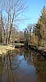
The Boven Sling near Winterswijk .
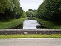
Bielheimerbeek between Westendorp and Doetinchem .


Individual evidence
- ↑ a b c Display board on the upper course
- ↑ a b Water directory of the State Office for Nature, Environment and Consumer Protection NRW 2006 ( Memento from February 15, 2010 in the Internet Archive ) (PDF; 1.03 MB)
- ↑ See Achterhoek and Westmünsterland rivers .
- ↑ river landscape rivierenlandschap achterhoek · westmünsterland. (PDF; 5.3 MB) Four beautiful bike tours. Retrieved October 2, 2011 .